Hiranai, Aomori
| Hiranai 平内町 | |||
|---|---|---|---|
| Town | |||
 Hiranai Town Hall | |||
| |||
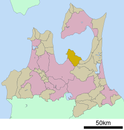 Location of Hiranai in Aomori Prefecture | |||
 Hiranai | |||
| Coordinates: 40°55′33.4″N 140°57′21.1″E / 40.925944°N 140.955861°ECoordinates: 40°55′33.4″N 140°57′21.1″E / 40.925944°N 140.955861°E | |||
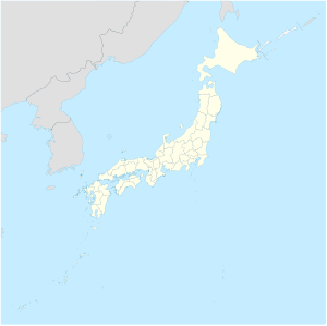
| Country | Japan | ||
| Region | Tōhoku | ||
| Prefecture | Aomori | ||
| Area | |||
| • Total | 217.08 km2 (83.82 sq mi) | ||
| Population (September 2018) | |||
| • Total | 11,159 | ||
| • Density | 51/km2 (130/sq mi) | ||
| Time zone | UTC+9 (Japan Standard Time) | ||
| - Tree | Japanese red pine | ||
| - Flower | Camellia | ||
| - Bird | Swan | ||
| Phone number | 017-755-2111 | ||
| Address | 63 Kominato, Hiranai-machi, Higashitsugaru-gun, Aomori-ken 039-3393 | ||
| Website | Official website | ||


Hiranai (Japanese:
Etymology
The name Hiranai is thought to have originated from the Ainu who originally inhabited the area. The Ainu words for pira (ピラ, cliff) and nay (ナイ, river) are said to be the original name of the area, due to its geography as a valley in the interior of the mountainous Natsudomari Peninsula. However, the current Japanese pronunciation and meaning of the town's name, Hiranai (平内, 平 hira "flat", and 内 nai "inside") is descriptive of the valley, but is based on the flat area inside of the mountains or the bay that surrounds it.
History
During the Edo period, Hiranai was a village. On September 17, 1656, the village became part of Kuroishi Domain controlled by the Tsugaru clan.[2] In July 1871, with the abolition of the han system, Kuroishi Domain briefly became Kuroishi Prefecture, and was merged into the newly created Aomori Prefecture in September 1871. During the cadastral reform of 1889, Natsudomari Peninsula was divided into the three villages of Naka-Hiranai, Nishi-Hiranai, and Higashi-Hiranai. On October 1, 1928, Naka-Hiranai became a town, renaming itself Kominato.
Nishi-Hiranai village's station, Nishi-Hiranai Station opened in 1939. The station was built to provide access to the Aomori Sanatorium,a facility to treat the soldiers who were injured during the Pacific War. The climate of Natsudomari Peninsula and the proximity to Asamushi Onsen] was of benefit to the wounded soldiers. After the war's conclusion, the sanatorium was closed.[3]
On March 31, 1955, Kominato merged with Nishi-Hiranai and Higashi-Hiranai to form the town, Hiranai.[4] On May 20, 1963, Emperor Shōwa and Empress Kōjun visited Hiranai to plant a Japanese red pine in the Yogoshiyama Forest Park for the 14th National Tree Planting.[5]
In 2012, Hiranai won a competition amongst towns and cities in Aomori Prefecture for who could produce the best advertisement film for their town. The film was titled, It's not "The Town that Nobody Knows"! (しらない町じゃないよ! Shiranai-machi janaiyo!) as a play on the pronunciation of the town's name and that the town isn't well known. The commercial features a child looking for the town, Shiranai, but nobody knows where that is. She then is told that she is probably looking for Hiranai and that it's not a town that nobody knows. This phrase from the film is well-known by the town's citizens.[6]
Demographics
Per Japanese census data,[7] the population of Hiranai has decreased by 29.5% over the past 40 years.
| Census Year | Population |
|---|---|
| 1970 | 17,551 |
| 1980 | 17,501 |
| 1990 | 16,103 |
| 2000 | 14,528 |
| 2010 | 12,361 |
Geography
Hiranai occupies the Natsudomari Peninsula, the northern end of the Ōu Mountain Range that juts into central Mutsu Bay. The town's population is concentrated near the Japan National Route 4 passing through the east and west of the town and the Aoimori Railway Line (formerly the Tōhoku Main Line). The town office is in the settlement of Kominato, the central part of Hiranai centered around the valley of the Kominato River. The Kominato River begins in the mountains in the south of Hiranai, and flows north through the mountains until it reaches the flat land the town is situated on. After passing through Kominato, it joins the Morita River, which empties into Mutsu Bay shortly after their confluence. The southern part of Hiranai is mainly mountainous. The edges of the town make up the bulk of the Asamushi-Natsudomari Prefectural Natural Park.[8]
Climate
The town has a cold humid continental climate (Köppen Cfb) characterized by warm short summers and long cold winters with heavy snowfall. The average annual temperature in Hiranai is 9.8 °C. The average annual rainfall is 1262 mm with September as the wettest month. The temperatures are highest on average in August, at around 22.8 °C, and lowest in January, at around -2.0 °C.
| Climate data for Hiranai, Aomori | |||||||||||||
|---|---|---|---|---|---|---|---|---|---|---|---|---|---|
| Month | Jan | Feb | Mar | Apr | May | Jun | Jul | Aug | Sep | Oct | Nov | Dec | Year |
| Average high °C (°F) | 1.3 (34.3) |
1.9 (35.4) |
5.8 (42.4) |
12.8 (55) |
18.1 (64.6) |
20.8 (69.4) |
24.8 (76.6) |
26.8 (80.2) |
23.2 (73.8) |
17.6 (63.7) |
10.7 (51.3) |
4.4 (39.9) |
26.8 (80.2) |
| Average low °C (°F) | −5.2 (22.6) |
−5.3 (22.5) |
−2.2 (28) |
2.9 (37.2) |
7.8 (46) |
12.5 (54.5) |
17.2 (63) |
18.9 (66) |
14.2 (57.6) |
7.6 (45.7) |
2.3 (36.1) |
−2.2 (28) |
−5.3 (22.5) |
| Average precipitation mm (inches) | 123 (4.84) |
95 (3.74) |
82 (3.23) |
71 (2.8) |
81 (3.19) |
97 (3.82) |
113 (4.45) |
110 (4.33) |
156 (6.14) |
115 (4.53) |
108 (4.25) |
111 (4.37) |
1,262 (49.69) |
| Source: "NowData - Climate: Hiranai". Climate-Data.org. Retrieved 2018-02-17. | |||||||||||||
Neighbouring municipalities
Economy
The economy of Hiranai is heavily dependent on commercial fishing. Some of the locally caught seafood include sea urchin roe, sea cucumber, scallops, abalone and squid.[9] Tourism also plays a role in the economy, with beaches in close proximity to the city of Aomori in summer, ski resorts in winter, and onsen all year drawing tourists.
Education
Hiranai has three public elementary schools and three public middle schools operated by the town government and one public high school operated by the Aomori Prefectural Board of Education. The town also has one private high school.
Transportation
Railway

Highway

- Aomori Prefecture Route 9
- Aomori Prefecture Route 123
- Aomori Prefecture Route 206
- Aomori Prefecture Route 207
- Aomori Prefecture Route 209
- Aomori Prefecture Route 210
- Aomori Prefecture Route 215
- Aomori Prefecture Route 269
Local attractions
- Yogoshiyama Forest Park is run by the town featuring multiple attractions, with more than 3,000 kinds of succulent plants grouped in a large greenhouse of 990 square meters from different parts of the world, including the Americas and Africa. Cacti and flowers of tropical origin bloom year-round.[10] The park also has ski and snowboarding facilities, including a ski lift.[11]
- The Kominato shallow shore or swan nesting area (浅所海岸 asadokoro kaigan) is the only designated natural monument in Japan for the observation of swans. Tundra swan from Siberia come to the region during the winter. A local legend says that the Tsugaru clan was at risk of losing what would become Hiranai to the Nanbu clan. After the Tsugaru forces prayed for help against the Nanbu, a massive flock of swans appeared. The Nanbu couldn't see the swans, but they mistook their honking for the sound of arriving Tsugaru reinforcements. The Nanbu retreated, preserving the border between the Tsugaru's Kuroishi Domain and the Nanbu's Shichinohe Domain. Hiranai maintains a counter for the amount of swans staying in the area during the winter.[12]
Notable people from Hiranai
- Takahashi Chikuzan - professional Tsugaru-jamisen musician
- Toru Hosokawa - professional baseball player
- Shinkishi Hatai - Biologist
References
- ↑ official home page statistics (in Japanese)
- ↑ Oniyanagi, Yoshiteru (July 1, 2005). 平内町史 年表 [Chronological Table of Hiranai History] (in Japanese). Kominato, Hiranai, Aomori, Japan: Hiranai History Compilation Committee.
- ↑ "駅や築港は国策に翻弄=21". www.mutusinpou.co.jp.
- ↑ "平内のおいたち". www.town.hiranai.aomori.jp.
- ↑ "全国植樹祭開催状況" (PDF). www.rinya.maff.go.jp.
- ↑ http://www.aba-net.com/cm/2012/index.html
- ↑ Hiranai population statistics
- ↑ "公園計画図~浅虫夏泊県立自然公園~|青森県庁ウェブサイト Aomori Prefectural Government". www.pref.aomori.lg.jp.
- ↑ http://www.town.hiranai.aomori.jp/index.cfm/10,0,61,161,html
- ↑ http://aoimorirailway.com/archives/chiiki-town/hiranai
- ↑ http://www.town.hiranai.aomori.jp/index.cfm/7,124,30,html
- ↑ http://www.town.hiranai.aomori.jp/index.cfm/8,0,73,311,html
External links
- Official website (in Japanese)
| Wikimedia Commons has media related to Hiranai, Aomori. |