Aomori Expressway
| |
|---|---|
|
青森自動車道 | |
| Route information | |
| Length | 15.6 km[1] (9.7 mi) |
| Existed | 2003[2] – present |
| Major junctions | |
| From |
Aomori Interchange in Aomori, Aomori |
| To |
Aomori-higashi Interchange in Aomori, Aomori Aomori Prefectural Route 47 Aomori Prefectural Route 123 |
| Highway system | |
|
National highways of Japan Expressways of Japan | |

The Aomori Expressway (青森自動車道 Aomori Jidōsha-dō) is a two-lane national expressway in Aomori, Aomori Prefecture, Japan. It is owned and operated by East Nippon Expressway Company and is signed E4A as a direct extension of the Tōhoku Expressway.[3]
Route description
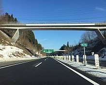
.jpg)
The expressway is officially referred to as the Tōhoku Jūkan Expressway Hachinohe Route.[4]
The expressway serves as an extension to the Tōhoku Expressway (which terminates at Aomori Interchange) and runs through southern areas of the city of Aomori.[5] From Aomori Interchange, it runs east, crossing under the tracks of the Tōhoku Shinkansen. Soon after the expressway meets National Route 7, which serves for several kilometers from here as a frontage road to the expressway. Eventually, the two roads have are linked by the Aomori-chūō Interchange where tolls are collected for the entire expressway, including any tolls accrued from travelling from the Tōhoku Expressway. The expressway continues east and splits from National Route 7 before it comes to its end at Aomori-higashi Interchange near the western terminus of the Michinoku Toll Road.
The speed limit is 70 km/h for the entire route.
History
Construction on Aomori Expressway began in 1999 and was opened to traffic on September 28, 2003. The completion of the expressway reduced travel times from the Tōhoku Expressway to Central Aomori by 11 minutes and reduced congestion along the Aomori West Bypass.[6]
Future
Though the Aomori Expressway terminates at Aomori-higashi Interchange, it is planned to eventually connect with the northern terminus of the Hachinohe Expressway in the town of Oirase via a series of toll roads.
Junction list
The entire expressway is in Aomori Prefecture. Also, it is to be noted that the expressway is a direct extension of the Tōhoku Expressway. Therefore, the distance and exit numbers continue from the sequence of the Tōhoku Expressway.
| Location | km | mi | Exit | Name | Destinations | Notes | |
|---|---|---|---|---|---|---|---|
| Through to | |||||||
| Aomori | 677.4 | 420.9 | 54 | Aomori | Access only from northbound Tōhoku Expressway and to southbound Tōhoku Expressway. | ||
| 683.5 | 424.7 | 55 | Aomori-chūō | Tolls are collected here for both Aomori-higashi IC and Aomori-chūō IC | |||
| 688.1 | 427.6 | — | Emergency Exit | Access for Aomori Chūō Hospital Authorized vehicles only | |||
| 693 | 431 | 56 | Aomori-higashi | Pref. Route 47 (Aomori-higashi Inter Route) Pref. Route 123 (Shimizugawa Takizawanonai Route) | At-grade junction Michinoku Toll Road is to the right | ||
| Through to | |||||||
1.000 mi = 1.609 km; 1.000 km = 0.621 mi
| |||||||
References
- ↑ "E-NEXCO Expressway Data". Retrieved 2008-04-13.
- ↑ Tohoku Regional Bureau, Ministry of Land, Infrastructure and Transport. "Status of Aomori Expressway after Opening". Archived from the original on 2005-01-24. Retrieved 2008-04-15.
- ↑ "Japan's Expressway Numbering System". www.mlit.go.jp.
- ↑ Ministry of Land; Infrastructure and Transport. "High Standard Trunk Road Map" (PDF). Archived from the original (pdf) on 2011-09-20. Retrieved 2008-04-13.
- ↑ "Routes covered by the Expressway Numbering System". www.mlit.go.jp.
- ↑ http://www.mlit.go.jp/road/ir/ir-hyouka/20jigo/3_h20_18.pdf
External links
- (in Japanese) East Nippon Expressway Company
Route map: