Kuroishi, Aomori
| Kuroishi 黒石市 | |||
|---|---|---|---|
| City | |||
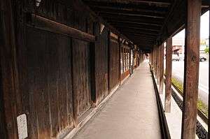 Nakamachi | |||
| |||
 Location of Kuroishi in Aomori Prefecture | |||
 Kuroishi | |||
| Coordinates: 40°38′33.4″N 140°36′40.7″E / 40.642611°N 140.611306°ECoordinates: 40°38′33.4″N 140°36′40.7″E / 40.642611°N 140.611306°E | |||
| Country | Japan | ||
| Region | Tōhoku | ||
| Prefecture | Aomori | ||
| Area | |||
| • Total | 217.05 km2 (83.80 sq mi) | ||
| Population (October 1, 2017) | |||
| • Total | 32,260 | ||
| • Density | 150/km2 (380/sq mi) | ||
| Time zone | UTC+9 (Japan Standard Time) | ||
| Symbols | |||
| • Tree | Painted maple (Acer mono) | ||
| • Flower | Apple (Malus domestica) | ||
| • Bird | Japanese wagtail (Motacilla grandis) | ||
| Phone number | 0173-42-2111 | ||
| Address | 11-1 Ichinomachi, Kuroishi-shi, Aomori-ken 036-0396 | ||
| Website | Official website | ||


Kuroishi (黒石市 Kuroishi-shi) is a city located in Aomori Prefecture, Japan. As of 1 October 2017, the city had an estimated population of 32,260 and a population density of 150 persons per km2. The total area of the city is 217.05 square kilometres (83.80 sq mi).
Geography
Kuroishi is located in west-central Aomori Prefecture. Part of the city is within the borders of the Kuroishi Onsenkyō Prefectural Natural Park. The city has a cold humid continental climate (Köppen Dfa) characterized by warm short summers and long cold winters with heavy snowfall. The average annual temperature in Kuroishi is 9.6 °C. The average annual rainfall is 1343 mm with September as the wettest month.The temperatures are highest on average in August, at around 23.3 °C, and lowest in January, at around -2.9 °C.[1]
Neighbouring municipalities
Demographics
Per Japanese census data,[2] the population of Kuroishi has remained relatively steady over the past 40 years.
| Census Year | Population |
|---|---|
| 1970 | 37,690 |
| 1980 | 40,755 |
| 1990 | 39,213 |
| 2000 | 39,059 |
| 2010 | 36,132 |
History
The area of Kuroishi was part of the holdings of the Tsugaru clan of Hirosaki Domain in the Edo period, and became the semi-independent Kuroishi Domain in 1809. After the Meiji Restoration, the town of Kuroishi was established in 1898 within Minaitsugaru District in Aomori Prefecture.
The modern city was founded on July 1, 1954, from the merger of the town of Kuroishi absorbing the villages of Nakago, Rokugo, Yamagata and Aseishi. On October 1, 1956, Kuroishi absorbed a portion of Onoe.
Government
Kuroishi has a mayor-council form of government with a directly elected mayor and a unicameral city legislature of 16 members.
Economy
The economy of Kuroishi is heavily dependent on agriculture. The city serves as a minor regional commercial center. Agricultural produce includes rice and apples.
Education
Kuroishi has nine public elementary schools and two public junior high schools operated by the city government and two public high schools operated by the Aomori Prefectural Board of Education. The prefecture also operates one special education school.
Transportation
Railway
Highway
Sister city relations


Local attractions
- Nakamachi Komise Street
- Tsugaru Traditional Crafts Centre
- Kuroishi Neputa Festival
- Kuroishi Onsenkyō Prefectural Natural Park
Noted people from Kuroishi
- Ujaku Akita, playwright, author of children's books
- Takahito Kudo, professional baseball player
References
- ↑ Kuroishi climate data
- ↑ Kuroishi population statistics
- ↑ "US-Japan Sister Cities by State". Asia Matters for America. Honolulu, HI: East-West Center. Retrieved 20 November 2015.
- ↑ "Yeongcheon official home page". Sister cities. Retrieved 20 November 2015.
External links
| Wikimedia Commons has media related to Kuroishi, Aomori. |
- Official website(in Japanese)