Matsumoto, Nagano
| Matsumoto 松本市 | |||
|---|---|---|---|
| Special city | |||
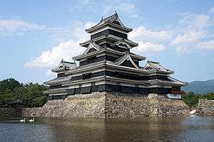 Matsumoto Castle | |||
| |||
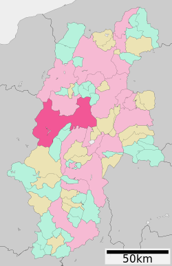 Location of Matsumoto in Nagano Prefecture | |||
 Matsumoto | |||
| Coordinates: 36°14′16.8″N 137°58′19.1″E / 36.238000°N 137.971972°ECoordinates: 36°14′16.8″N 137°58′19.1″E / 36.238000°N 137.971972°E | |||
| Country | Japan | ||
| Region | Chūbu (Kōshin'etsu) | ||
| Prefecture | Nagano Prefecture | ||
| Government | |||
| • Mayor | Akira Sugenoya | ||
| Area | |||
| • Total | 978.47 km2 (377.79 sq mi) | ||
| Population (October 1, 2016) | |||
| • Total | 241,102 | ||
| • Density | 246/km2 (640/sq mi) | ||
| Time zone | UTC+9 (Japan Standard Time) | ||
| - Tree | Japanese Red Pine | ||
| - Flower | Japanese azalea | ||
| Phone number | 0263-34-3000 | ||
| Address | 3-7 Marunouchi, Matsumoto-shi, Nagano-ken 390-8620 | ||
| Website | www.city.matsumoto.nagano.jp | ||


Matsumoto (松本市 Matsumoto-shi) is a city located in Nagano Prefecture, Japan.[1] Matsumoto is designated as a Special city.[2] As of 1 October 2016, the city had an estimated population of 241,102, and a population density of 246 persons per km². Its total area is 978.47 square kilometres (377.79 sq mi).
History
Matsumoto is located in former Shinano Province and was the provincial capital from the Heian period onwards. The area developed as the castle town of Matsumoto Domain under the Tokugawa shogunate of the Edo period. Modern Matsumoto Town was established with the creation of the municipalities system on April 1, 1889. It was raised to city status on May 1, 1907.
On February 1, 1925 Matsumoto absorbed the village of Matsumoto (from Higashichikuma District).
The city expanded further by annexing the Kanda hamlet of the village of Nakayama from Higashichikuma District on April 1, 1943, the villages of Nakayama, Shimadachi and Shimauchi (all from Higashichikuma District) on April 1, 1954, the villages of Wada, Niimura, Kanbayashi, Sasaga, Yoshikawa, Kotobuki, Okada, Iriyamabe, Satoyamabe and Imai (all from Higashichikuma District) on August 1, 1954 and Kitauchida ward (excluding the Gakenoyu hamlet from the Minamiuchida ward of the village of Kataoka, from Higashichikuma District) from the city of Shiojiri on April 1, 1960. This was followed by the Gakenoyu hamlet of Minamiuchida ward of the village of Kataoka (from Higashichikuma District) from the city of Shiojiri on April 1, 1961, the village of Hongo (from Higashichikuma District) on May 1, 1974 and parts of Seba hamlet (the hamlet of Kukohigashi) from the city of Shiojiri on April 1, 1982.
Between the days of June 27 and June 28, 1994, the Matsumoto Incident sarin gas attack occurred.
Matsumoto was proclaimed a Special City with increased local autonomy on November 1, 2000. Matsumoto annexed the villages of Azumi, Azusagawa and Nagawa (all from Minamiazumi District), and the village of Shiga (from Higashichikuma District) on April 1, 2005. This was followed by the town of Hata (from Higashichikuma District) on March 31, 2010.
Geography
Matsumoto is located in the Matsumoto Basin of central Nagano Prefecture surrounded by mountains and is acclaimed for its beautiful views. It is approximately 75 kilometers south of the prefectural capital at Nagano City, and 124 kilometers from central Tokyo. The 3000 meter Hida Mountains are to the west of the city.
Surrounding municipalities
Climate
Matsumoto has a humid continental climate (Köppen climate classification Dfa) bordering on a humid subtropical climate (Koppen Cfa), with hot summers and cold winters. Precipitation is quite high in summer, but the weather is somewhat drier in winter.
| Climate data for Matsumoto, Nagano (1981~2010) | |||||||||||||
|---|---|---|---|---|---|---|---|---|---|---|---|---|---|
| Month | Jan | Feb | Mar | Apr | May | Jun | Jul | Aug | Sep | Oct | Nov | Dec | Year |
| Record high °C (°F) | 18.8 (65.8) |
21.1 (70) |
25.9 (78.6) |
30.9 (87.6) |
32.3 (90.1) |
35.9 (96.6) |
37.9 (100.2) |
38.5 (101.3) |
35.3 (95.5) |
31.8 (89.2) |
25.6 (78.1) |
21.5 (70.7) |
38.5 (101.3) |
| Average high °C (°F) | 5.0 (41) |
6.0 (42.8) |
10.5 (50.9) |
17.8 (64) |
22.9 (73.2) |
26.0 (78.8) |
29.4 (84.9) |
31.1 (88) |
25.7 (78.3) |
19.3 (66.7) |
13.6 (56.5) |
8.0 (46.4) |
17.9 (64.2) |
| Daily mean °C (°F) | −0.4 (31.3) |
0.2 (32.4) |
3.9 (39) |
10.6 (51.1) |
16.0 (60.8) |
19.9 (67.8) |
23.6 (74.5) |
24.7 (76.5) |
20.0 (68) |
13.2 (55.8) |
7.4 (45.3) |
2.3 (36.1) |
11.8 (53.2) |
| Average low °C (°F) | −5.2 (22.6) |
−4.8 (23.4) |
−1.5 (29.3) |
4.1 (39.4) |
9.9 (49.8) |
14.9 (58.8) |
19.2 (66.6) |
20.2 (68.4) |
15.9 (60.6) |
8.4 (47.1) |
2.1 (35.8) |
−2.7 (27.1) |
6.7 (44.1) |
| Record low °C (°F) | −24.8 (−12.6) |
−20.4 (−4.7) |
−17.9 (−0.2) |
−10.1 (13.8) |
−2.7 (27.1) |
2.3 (36.1) |
10.2 (50.4) |
8.0 (46.4) |
3.0 (37.4) |
−3.6 (25.5) |
−8.4 (16.9) |
−19.2 (−2.6) |
−24.8 (−12.6) |
| Average precipitation mm (inches) | 35.9 (1.413) |
43.5 (1.713) |
79.6 (3.134) |
75.3 (2.965) |
100.0 (3.937) |
125.7 (4.949) |
138.4 (5.449) |
92.1 (3.626) |
155.6 (6.126) |
101.9 (4.012) |
54.9 (2.161) |
28.1 (1.106) |
1,031 (40.591) |
| Average snowfall cm (inches) | 28 (11) |
24 (9.4) |
17 (6.7) |
1 (0.4) |
0 (0) |
0 (0) |
0 (0) |
0 (0) |
0 (0) |
0 (0) |
0 (0) |
9 (3.5) |
79 (31) |
| Average precipitation days (≥ 0.5 mm) | 6.0 | 6.6 | 9.6 | 9.1 | 9.7 | 11.1 | 13.1 | 9.7 | 11.2 | 9.0 | 6.3 | 5.4 | 106.8 |
| Average snowy days | 11.2 | 9.8 | 4.9 | 0.4 | 0.0 | 0.0 | 0.0 | 0.0 | 0.0 | 0.0 | 0.1 | 3.7 | 30.1 |
| Mean monthly sunshine hours | 170.7 | 163.5 | 185.0 | 202.1 | 209.0 | 163.6 | 171.3 | 205.4 | 141.8 | 159.9 | 159.2 | 166.0 | 2,097.5 |
| Source #1: Japan Meteorological Agency[3] | |||||||||||||
| Source #2: Japan Meteorological Agency (records)[4] | |||||||||||||
Education
Universities and colleges
Primary and secondary education
Matsumoto has 29 public elementary schools operated by the city government, one operated by the national government and one private elementary school. The city also manages 19 public middle schools, with one more middle school shared between Matsumoto and neighbouring Asahi. There is one public middle school operated by the national government and one private middle school. The city has seven public high schools operated by the Nagano Prefectural Board of Education and six private high schools. The city also has a North Korean school, Nagano Korean Elementary and Junior High School (長野朝鮮初中級学校).
Transportation
Airport
Railway
- JR East – Shinonoi Line
- Murai - Hirata - Minami-Matsumoto - Matsumoto
- JR East – Ōito Line
- Alpico Kōtsū - Kamikōchi Line
- Matsumoto - Nishi-Matsumoto - Nagisa - Shinano-Arai - Ōniwa - Shimonii - Kitanii-Matsumotodaigakumae - Niimura - Samizo - Moriguchi - Shimojima - Hata - Endō - Shin-Shimashima
Highway
Sister cities
- Fujisawa, Kanagawa, from July 29, 1961
- Himeji, Hyōgo, from November 17, 1966
- Takayama, Gifu, from November 1, 1971


Local attractions
Matsumoto is attractive to travellers not only because of the traditional culture but also its calm climate and local products. Matsumoto soba is famous for its delicate taste [5] Local attractions include:
- Matsumoto Castle, built more than 400 years ago. It is a Japanese National Treasure
- Kaichi School Museum, Meiji period building housing the first middle school in Japan
- Asama Onsen
- Saito Kinen Festival Matsumoto, held every August by conductor Seiji Ozawa and featuring the Saito Kinen Orchestra
- Kamikōchi mountain area
- The Kiso Valley, a valley located Southwest of Matsumoto along which the historic Nakasendo route of the Edo period went through.
Sports
Matsumoto is represented in the J. League of football with its local club, Matsumoto Yamaga FC based at the Alwin Stadium in Kambayashi.
It was one of the host cities of the official Women's Volleyball World Championship for its 1998 and 2010 editions.
Gallery
 Four Pillars Shrine
 Kaichi School
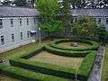 Garden in former Matsumoto High School (present day of Shinshu University)
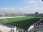 Matsumoto Alwin football stadium
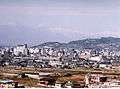 View of downtown Matsumoto from Mount Koubou
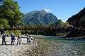 Kappa Bridge in Kamikochi
 Matsumoto City Museum of Art
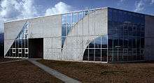 Matsumoto Ukiyoe Museum
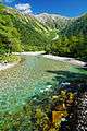 Azusa River in Kamikochi
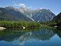 Taisho Pond in Kamikochi
References
- ↑ Nussbaum, Louis-Frédéric. (2005). "Maatsumoto" in Japan Encyclopedia, p. 618; "Chūbu" at p. 126.
- ↑ Jacobs, A.J. "Japan's Evolving Nested Municipal Hierarchy: The Race for Local Power in the 2000s," Urban Studies Research, (2011); Table 3; retrieved 20132-2-11.
- ↑ "平年値(年・月ごとの値)". Japan Meteorological Agency. Retrieved 2010-03-06.
- ↑ "観測史上1~10位の値(年間を通じての値)". Japan Meteorological Agency. Retrieved 2011-11-18.
- ↑ http://welcome.city.matsumoto.nagano.jp/contents03+index.id+15.htm
External links
![]()
| Wikivoyage has a travel guide for Matsumoto. |
- Official Website (in Japanese)
- Matsumoto City Tourism Website (in English)
| Core city | |
|---|---|
| Special city | |
| Cities | |
| Districts | |