Japan National Route 4
| |
|---|---|
| Kokudō Yongō (国道4号) | |
 | |
| Route information | |
| Length | 743.6 km (462.1 mi) |
| Existed | April 1, 1965 – present |
| Major junctions | |
| South end |
|
| North end |
|
| Highway system | |
|
National highways of Japan Expressways of Japan | |

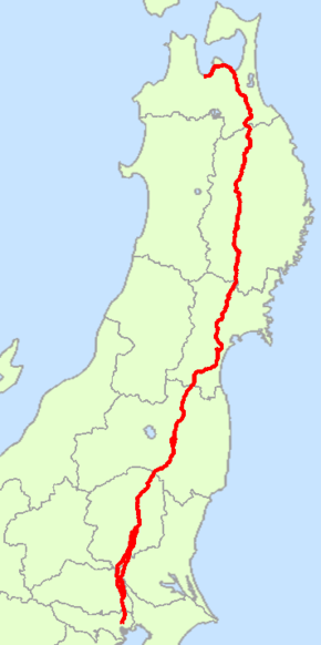
National Route 4 (国道4号 Kokudō Yongō) is a major national highway in eastern Honshū, Japan. It has the longest main line of any highway in Japan at 743.6 km (462.1 mi). With its extensions included it is the second longest highway in Japan 854.9 km (531.2 mi) after National Route 58, which is 884.4 km (549.5 mi) long with its maritime sections included.[1] The highway connects Tokyo and Aomori via Utsunomiya, Kōriyama and Morioka.
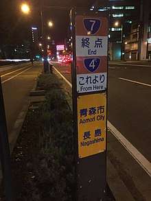
From Saitama Prefecture to Iwate Prefecture, it parallels the Tōhoku Expressway; from Morioka to Hachinohe, it parallels the Hachinohe Expressway. At its northern terminus it links with National Route 7.[2]
Route data
- Total length: 743.6 km (462.1 mi)
- Origin point: Chūō, Tokyo (originates at Nihonbashi, which is also the origin of Routes 1, 6, 14, 15, 17 and 20)
- End point: Aomori (ends at the eastern terminus of the west bypass of National Route 7)
- Major cities on its route: Kasukabe, Koga, Utsunomiya, Kōriyama, Fukushima (Nakadōri), Sendai, Furukawa, Hiraizumi, Morioka, Ninohe, Towada, Noheji, and Hiranai
Municipalities it passes through
- Tokyo
- Saitama Prefecture
- Ibaraki Prefecture
- Tochigi Prefecture
- Nogi - Oyama - Shimotsuke - Kaminokawa, Shimotsuke, Utsunomiya - Takanezawa - Sakura - Yaita - Otawara - Nasushiobara - Nasu
- Fukushima Prefecture
- Miyagi Prefecture
- Shiroishi - Zaō - Ōgawara - Murata - Shibata - Iwanuma - Natori - Taihaku-ku, Sendai - Wakabayashi-ku, Sendai - Miyagino-ku, Sendai - Izumi-ku, Sendai - Tomiya - Taiwa - Shiroishi - Ōhira - Ōsaki - Kurihara
- Iwate Prefecture
- Aomori Prefecture
History
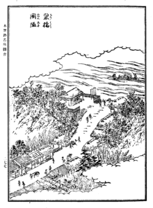
National Route 4 was initially established as the Ōshū Kaidō (奥州街道) and Nikkō Kaidō (日光街道) as two of the five routes of the Edo period. It was established by Tokugawa Ieyasu for government officials traveling through the area to connect Edo (modern-day Tokyo) with Mutsu Province and the present-day city of Shirakawa, Fukushima Prefecture, Japan. There were also many roads that connected to the Ōshū Kaidō that are included in National Route 4. One such sub-route was the Sendaidō (仙台道), which connected Mutsu Province with Sendai. From Sendai, the Matsumaedō (松前道) connected Sendai with Hakodate, Hokkaidō. Though the Ōshū Kaidō has only 27 post stations, there were over 100 designated post stations when the subroutes are included.[3] Some sections and markers of the Ōshū Kaidō in their original state can still be found alongside National Route 4, the Hachinohe Expressway, and Tōhoku Expressway.[4]
On December 4, 1952 First Class National Highway 4 (from Tokyo to Aomori) was established. The route was reclassified as a General National Highway on April 1, 1965.
Intersecting routes
- in Tokyo
- in Saitama Prefecture
- National Route 298 at Sōka
- National Route 463 at Koshigaya
- National Route 16 at Kasukabe
- National Route 125 at Kuki
- in Ibaraki Prefecture
- in Tochigi Prefecture
- National Route 50 at Oyama
- National Route 352 at Shimotsuke
- Routes 119, 121 and 123 at Utsunomiya
- National Route 408 at Takanezawa
- National Route 293 at Sakura
- National Route 461 at Yaita
- Route 461 at Ōtawara
- National Route 400 at Nasushiobara
- in Fukushima Prefecture
- Routes 289 and 294 at Shirakawa
- National Route 118 at Sukagawa
- Routes 49 and 288 at Kōriyama
- National Route 459 at Nihonmatsu
- Routes 13, 114 and 115 at Fukushima
- National Route 399 at Date
- in Miyagi Prefecture
- Routes 113 and 457 at Shiroishi
- National Route 349 at Shibata
- Route 6 at Iwanuma
- National Route 286 at Taihaku-ku, Sendai
- Routes 45 and 48 at Miyagino-ku, Sendai
- Routes 47, 108 and 347 at Ōsaki
- National Route 398 at Kurihara
- in Iwate Prefecture
- Routes 284, 342 and 457 at Ichinoseki
- Routes 343 and 397 at Ōshū
- National Route 107 at Kitakami
- National Route 283 at Hanamaki
- Routes 46, 106, 396 and 455 at Morioka
- National Route 282 at Takizawa
- National Route 281 at Iwate
- in Aomori Prefecture
- National Route 104 at Sannohe
- Route 104 at Nanbu
- National Route 454 at Gonohe
- Routes 45 and 102 at Towada
- National Route 394 at Shichinohe
- National Route 279 at Noheji
- Routes 7 and 103 at the northern terminus in Aomori.
See also
Edo Five Routes, the five centrally administered routes, or kaidō, that connected the capital of Japan at Edo (now Tokyo) with the outer provinces during the Edo period.
References
- ↑ "Road Statistics Annual Report 2016" (PDF). Retrieved 2017-10-26.
- ↑ 一般国道4号 (in Japanese). Ministry of Land, Infrastructure, Transport and Tourism. Kanto Regional Development Bureau. Archived from the original on 2010-07-30. Retrieved 2010-11-29.
- ↑ Ōshū Kaidō Map. Yumekaidō. Accessed October 26, 2017.
- ↑ "The Oshu Kaido in Iwate". Retrieved 2017-10-26.
External links
Route map:
![]()