Belvedere Island
| El Potrero de la Punta del Tiburon, Kashow's Island, Peninsula Island, Promontory Island, Still Island | |
|---|---|
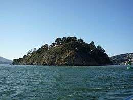 Belvedere Island in 2010 | |
 Belvedere Island  Belvedere Island  Belvedere Island | |
| Geography | |
| Coordinates | 37°52′18″N 122°28′07″W / 37.87158°N 122.46849°WCoordinates: 37°52′18″N 122°28′07″W / 37.87158°N 122.46849°W |
| Administration | |
| State | California |
| County | Marin County, California |
Belvedere Island (formerly, El Potrero de la Punta del Tiburon, Kashow's Island, Peninsula Island, Promontory Island, and Still Island)[1] is a rocky island in Marin County, California which was separated by a marsh from the mainland and has now been linked by two spits. Part of the town of Belvedere, California is located on the island.[2]
Natural history
There are a variety of flora and fauna represented on Belvedere Island. Presence of herons has been noted for a considerable period of time.[3] Some of the flora are common to nearby Ring Mountain, where a considerable floral biodiversity has been documented. Ring Mountain has also been established to have been a settlement area for early Native American inhabitants of this local area.[4]
History
The name Kashow's Island honors Israel Kashow who lived on the island.[1]
References
- 1 2 Durham, David L. (1998). California's Geographic Names: A Gazetteer of Historic and Modern Names of the State. Clovis, Calif.: Word Dancer Press. p. 601. ISBN 1-884995-14-4.
- ↑ U.S. Geological Survey. 2009. USGS Belvedere Island USGS San Francisco North Quad, California, Topographic Map
- ↑ Helen M. Pratt (1984). "Marin County California Heron Colonies". Western Birds. 14 (4): 169–184.
- ↑ C. Michael Hogan (2008) Ring Mountain, The Megalithic Portal, ed. A. Burnham
