Interstate 880
| ||||
|---|---|---|---|---|
| Nimitz Freeway | ||||
|
I-880 highlighted in red | ||||
| Route information | ||||
| Defined by Streets and Highways Code § 625 | ||||
| Maintained by Caltrans | ||||
| Length | 45.698 mi[1] (73.544 km) | |||
| History | 1930s as a state highway, 1983-84 as an interstate | |||
| Major junctions | ||||
| South end |
| |||
| North end |
| |||
| Location | ||||
| Counties | Santa Clara, Alameda | |||
| Highway system | ||||
| ||||
.svg.png)
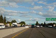
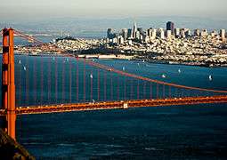
Interstate 880 (I-880) is an Interstate Highway in the San Francisco Bay Area connecting San Jose and Oakland, running parallel to the eastern shore of San Francisco Bay. For most of its route, I-880 is officially known as the Nimitz Freeway, after World War II fleet admiral Chester Nimitz, who retired to the Bay Area and lived on Yerba Buena Island.
Route description
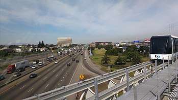
The southern terminus of I-880 is at its interchange with Interstate 280 and State Route 17 in San Jose. From there, it heads roughly northeast past the San Jose International Airport to U.S. Route 101. The Nimitz Freeway then turns northwest, running parallel to the southeastern shore of San Francisco Bay, connecting the cities of Milpitas, Fremont, Newark, Union City, Hayward, and San Leandro before reaching Oakland. In Oakland, I-880 passes by Oakland International Airport, Oakland–Alameda County Coliseum and Downtown Oakland. The northern terminus of I-880 is in Oakland at the junction with Interstate 80 and Interstate 580 (known as the MacArthur Maze), near the eastern approach of the Bay Bridge.
I-880 between I-238 in San Leandro and the MacArthur Maze is used as an alternate truck route; trucks over 4.5 tons are prohibited through Oakland on I-580.[2]
I-880 is part of the California Freeway and Expressway System,[3] and is part of the National Highway System,[4] a network of highways that are considered essential to the country's economy, defense, and mobility by the Federal Highway Administration.[5] Officially, the Nimitz Freeway designation is Route 880 from Route 101 to Route 80, as named by Senate Concurrent Resolution 23, Chapter 84 in 1958.[6]
An infamous misconception for certain commuters and businesses in San Jose is that I-880 extends from I-280 to SR 85 in Los Gatos (which would extend the length to 50 miles).
History
The state legislature added the proposed San Jose-Richmond East Shore Highway to the state highway system in 1933, and it became an extension of the previously short (San Rafael to the bay) Legislative Route 69,[7][8] and part of Sign Route 13 (soon changed to 17) in 1934.[9] From San Jose, this route temporarily followed existing Legislative Route 5 (present Oakland Road, Main Street, Milpitas Boulevard, and Warm Springs Boulevard) to SR 21 at Warm Springs, and then continued along existing county roads and city streets,[10] now known as Fremont Boulevard, Alvarado Boulevard, Hesperian Boulevard, Lewelling Boulevard, Washington Avenue, 14th Street, 44th Avenue, 12th Street, 14th Avenue, 8th Street, and 7th Street, into downtown Oakland. It then turned north at Cypress Street (now Mandela Parkway), passing through the Bay Bridge Distribution Structure and following a newly constructed alignment (signed as US 40) to El Cerrito.[11][12]
The first short piece of the new Eastshore Freeway opened to traffic on July 22, 1949, connecting Oak Street downtown with 23rd Avenue.[13][14] It was extended to 98th Avenue on June 1, 1950,[15] Lewelling Boulevard on June 13, 1952,[16] and Jackson Street (SR 92) on June 5, 1953.[17] At the San Jose end, the overlap with Route 5 between Bayshore Highway (US 101) and Warm Springs was bypassed on July 2, 1954.[18] Within Oakland, the double-decker Cypress Street Viaduct opened on June 11, 1957, connecting the freeway with the San Francisco–Oakland Bay Bridge.[19] The Oakland segment was extended south to Fremont Boulevard at Beard Road on November 14, 1957,[20] and the gap was filled on November 24, 1958,[21] soon after the state legislature named the highway after Fleet Admiral Chester W. Nimitz.[22] (The short spur to Route 5 at Warm Springs (now SR 262) remained in the state highway system as a branch of Route 69.[23]) As these sections opened, Sign Route 17 (and Legislative Route 69) was moved from its old surface routing, which mostly became local streets. Other than Route 5 south of Warm Springs, the portion from San Leandro into Oakland was also kept as part of Route 105 (now SR 185).[24]
Historic alignments
State Route 17
| |
|---|---|
| Location | French Camp–San Jose from 1926-9; Lathrop–Hayward[25] from 1929-31 |
| Existed | 1926–1931 |
| |
|---|---|
| Location | San Rafael–San Jose |
| Existed | 1929–1940s |
| |
|---|---|
| Location | San Rafael–Santa Cruz |
| Existed | 1940s–1984 north of I-280 |
Prior to 1984, the route known as I-880 used to be part of State Route 17, which was US 48[25] from current I-238 to US 101 from 1926 to 1931, then US 101E from 1929 to the 1940s. SR 17 used to run from Santa Cruz all the way through San Jose, Oakland; and then continued north via the Eastshore Freeway (Interstate 80) through Richmond to the Richmond-San Rafael Bridge and San Rafael.
In 1984 the segment of SR 17 from Interstate 280 in San Jose to the MacArthur Maze in Oakland was renumbered as I-880, and the portion of SR 17 from the MacArthur Maze to San Rafael was renumbered as part of I-580.
Nimitz Freeway
In 1947, construction commenced on a freeway to replace the street routing of SR 17 through the East Bay. As noted in detail above, the new freeway was named the "Eastshore Freeway", and with the subsequent addition of a freeway to replace the Eastshore Highway north of the MacArthur Maze in the mid 1950s, it ran, appropriately, almost the entire length of the east shore of San Francisco Bay. In 1958, the portion south of the MacArthur Maze was renamed the Nimitz Freeway in honor of WWII Admiral Nimitz, while the portion to the north retained the name Eastshore Freeway.
Historic Business U.S. Route 50
| |
|---|---|
| Location | Oakland–Castro Valley |
| Existed | ?–1964 |
The northern portion of I-880 was designated Business U.S. Route 50 for a time between the I-80 interchange and downtown Oakland.
Original routing of I-880 in Sacramento
| |
|---|---|
| Location | West Sacramento–Sacramento |
| Existed | 1971–1983 |
From 1971 to 1983, Interstate 880 was the original route designation for the Beltline Freeway, the northern bypass freeway for the Sacramento area. This freeway begins in West Sacramento as a fork from the original Interstate 80, continues northeast over the Sacramento River to its interchange with Interstate 5, continues east through the communities of North Sacramento and Del Paso Heights and ends at an interchange with the Roseville Freeway (Interstate 80). The now-designated Capital City Freeway was then the original I-80 routing, continuing southwest directly into downtown Sacramento. I-80 was then re-routed along the Beltline Freeway in 1983, while the Capital City Freeway became Interstate 80 Business.
Modern history
Cypress Viaduct and the 1989 Loma Prieta earthquake
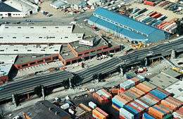
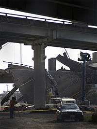
A large double-decker section in Oakland, known as the Cypress Street Viaduct, collapsed during the 1989 Loma Prieta earthquake, causing 42 deaths; initial estimates were significantly higher, but because many commuters on both sides of the bay had left early or stayed late to watch Game 3 of the San Francisco-Oakland World Series, the freeway was far less crowded than normal at the time of the quake.[26] This was the greatest loss of life caused by that earthquake. Rebuilding the affected section of the freeway took nearly a decade, due to environmental impact concerns, the feeling that the freeway divided the neighborhood, design considerations and most importantly a huge outcry from the West Oakland community demanding that the freeway find a new route - not in West Oakland. The protest was successful. The freeway reopened in July 1997 on a new route parallel to railroad tracks around the outskirts of West Oakland with the entire project being opened in 1999 and fully completed in 2001.
Although only about three miles (5 km) in length, the replacement freeway cost over $1.2 billion, for several reasons: it crossed over and under the elevated BART line to San Francisco; it squeezed between a post office, the West Oakland BART station, the Port of Oakland, a rail yard, and an East Bay Municipal Utility District sewage treatment plant; it occupied an entirely new right-of-way, which required the acquisition of large amounts of valuable industrial real estate near the Port of Oakland; and of course, it had to be earthquake resistant.[27]
The former path of the structure, Cypress Street, was renamed Mandela Parkway, and the median where the freeway stood became a landscaped linear park.[28]
Flood plains
Several aspects of the I-880 facility have been constructed in designated floodplains such as the 1990 interchange improvements at Dixon Landing Road. In that case the Federal Highway Administration was required to make a finding that there was no feasible alternative to the new ramp system as designed. In that same study, the FHWA produced an analysis to support the fact that adequate wetlands mitigation had been designed into the improvement project.[29]
Sound barriers
Due to high sound levels generated from this highway and the relatively dense urban development in the highway corridor, Caltrans has conducted numerous studies to retrofit the right-of-way with noise barriers. This activity has occurred in Oakland, San Leandro, Hayward, Newark and Fremont. During the 1989 widening of I-880 in parts of Newark and Fremont, scientific studies were conducted to determine the need for sound walls and to design optimum heights to achieve Federal noise standards.[30]
No interchange with SR 87/Guadalupe Freeway
Between Coleman Avenue and First Street in San Jose, State Route 87 (the Guadalupe Freeway) crosses above I-880 without an interchange, making it the only point in California where two freeways cross without a connection.[31] Because of its proximity to the runways at San Jose International Airport, Caltrans cannot construct elevated ramps without them interfering with flight paths. Tunneling underneath to build underground ramps would also make a significant environmental impact to the nearby Guadalupe River.[31]
Gasoline tanker accident in 2007
On April 29, 2007, a gasoline tanker overturned and caught fire on the connector between westbound I-80 and southbound I-880 on the MacArthur Maze interchange. The fire caused major damage to both this connector and one directly above (eastbound I-80 onto eastbound I-580). The overpass was replaced and re-opened 27 days later. The governor, Arnold Schwarzenegger, declared it as a State of emergency and all public transportation was free on the first commute day.[32]
2012-2015 I-880/I-280 Interchange improvement
Improvements to the I-280/I-880 and Stevens Creek Boulevard interchanges finished early 2015. Before construction, both interchanges shared a handful of ramps, but now, the two interchanges will be independent from one another. Construction began in late 2012 and the ramp from I-280 North to I-880 North opened in April 2015.[33]
Future
The I-880 Corridor Improvement Project, one of the last seismic retrofit projects of a major transportation corridor in California, consists of eight separate projects located in a 15-mile segment of the freeway between Oakland and Hayward.[34][35]
The overall goal of the project is to improve the seismic safety of the corridor. After the 1989 Loma Prieta earthquake, the California Department of Transportation (Caltrans) initiated Phase 1 of its seismic retrofit program. After the 1994 Northridge earthquake, Caltrans initiated Phase 2 of its seismic retrofit program, which included projects along the I-880 corridor.[36] Other goals include reducing traffic congestion and improving road quality.[37]
The individual projects included in the I-880 Corridor Improvement project are the retrofitting or replacement of the 5th Avenue, 23rd Avenue, 29th Avenue, Fruitvale Avenue, and High Street bridges in Oakland; improvements to both the I-238 and Highway 92 interchanges (the latter, a four-year project, completed in October 2011);[38] and an overall rehabilitation/repaving project along the entire segment. Construction will take place from 2006 to 2014, although certain projects may be completed as late as 2019. The total cost of the project is $462.7 million, provided by federal, state, and regional funds.
Exit list
Except where prefixed with a letter, postmiles were measured on the road as it was when the route was established, based on the alignment that existed at the time, and do not necessarily reflect current mileage. R reflects a realignment in the route since then, M indicates a second realignment, L refers an overlap due to a correction or change, and T indicates postmiles classified as temporary (for a full list of prefixes, see the list of postmile definitions).[1] Segments that remain unconstructed or have been relinquished to local control may be omitted. The numbers reset at county lines; the start and end postmiles in each county are given in the county column.
| County | Location | Postmile [1][39][40] | Exit [41] | Destinations | Notes |
|---|---|---|---|---|---|
| Santa Clara SCL 0.00-10.50 | San Jose | 0.00 | Continuation beyond I-280 | ||
| 0.00 | 1B | Southern terminus; I-280 exit 5C northbound, 5B southbound; CA 17 exits 26A-B northbound; stack interchange. | |||
| 0.41 | 1C | Stevens Creek Boulevard, West San Carlos Street | |||
| 1.25 | 1D | Bascom Avenue – Santa Clara | Signed as exits 1A (south) and 1B (north) northbound | ||
| 2.08 | 2 | ||||
| 2.67 | 3 | ||||
| 3.57 | 4A | First Street – Downtown San Jose | |||
| 4.08 | 4 | No access to US 101 north from I-880 south; signed as exits 4B (south) and 4C (north); US 101 exits 388B-C | |||
| 4.28 | 4D | Signed as exit 4C southbound | |||
| 5.34 | 5 | Brokaw Road | |||
| 6.71 | 7 | Montague Expressway (CR G4) | |||
| Milpitas | 7.69 | 8A | Great Mall Parkway, Tasman Drive | ||
| 8.42 | 8B | Signed as exits 8B (east) and 8C (west) southbound. No southbound entrance from McCarthy Blvd.; CA 237 exits 9B-C | |||
| | — | Southbound left exit and northbound entrance | |||
| 10.41 | 10 | Dixon Landing Road | Southbound exit and northbound entrance within Alameda County despite being a full interchange | ||
| Alameda ALA R0.00-R35.47 | Fremont | 2.28 | 12 | Signed as exits 12A (Mission Boulevard) and 12B (Warren Avenue) northbound | |
| 3.25 | 13 | Fremont Boulevard South, Cushing Parkway | Signed as exit 13B northbound | ||
| 4.71 | 15 | Auto Mall Parkway | |||
| Fremont–Newark line | 6.24 | 16 | Stevenson Boulevard | ||
| 7.19 | 17 | Mowry Avenue – Central Fremont | |||
| 8.84 | 19 | South end of SR 84 overlap | |||
| 10.30 | 21 | North end of SR 84 overlap | |||
| Fremont | 11.40 | 22 | Fremont Boulevard North, Alvarado Boulevard | ||
| 13.05 | 23 | Alvarado Niles Road | |||
| 13.67 | 24 | Whipple Road, Dyer Street | |||
| Hayward | 14.54 | 25 | Industrial Parkway | Northbound exit is via exit 24 | |
| 15.65 | 26 | Tennyson Road | |||
| 16.70 | 27 | CA 92 exits 26A-B | |||
| 17.60 | 28 | Winton Avenue | |||
| 18.35 | 29 | A Street – San Lorenzo | |||
| San Lorenzo | 20.16 | 30 | Hesperian Boulevard, Lewelling Boulevard – San Lorenzo | Signed as Hesperian Blvd northbound, Lewelling Blvd southbound | |
| San Leandro | 20.68 | 31A | Signed as exit 31 southbound; I-238 exits 16A/17B | ||
| 20.82 | 31B | Washington Avenue | Southbound exit is part of exit 31 | ||
| 22.84 | 33 | Marina Boulevard | Signed as exits 33A (east) and 33B (west) | ||
| 23.64 | 34 | Davis Street (SR 112) | |||
| Oakland | 24.77 | 35 | |||
| 25.50 | 36 | ||||
| 26.61 | 37 | 66th Avenue, Zhone Way – Oakland Coliseum | |||
| 27.71 | 38 | High Street (SR 77) – Alameda | |||
| 28.24– 28.69 | 39A | 29th Avenue, Fruitvale Avenue – Alameda | |||
| 28.93 | 39B | 23rd Avenue – Alameda | |||
| 29.80– 30.38 | 40 | Embarcadero, Fifth Avenue, 16th Avenue | No northbound entrance | ||
| 31.09 | 41A | Oak Street, Lakeside Drive | Northbound exit and southbound entrance | ||
| 31.2 | Jackson Street | Northbound entrance only | |||
| 31.6 | 41B | Broadway – Downtown Oakland | Northbound exit and southbound entrance | ||
| 31.68 | 42A | Northbound exit and southbound entrance | |||
| 32.1 | 42B | Market Street – Harbor Terminal | Northbound exit and southbound entrance | ||
| R32.79 | 42 | Broadway (to SR 61) – Alameda | New interchange added upon post-1989 Loma Prieta earthquake realignment; southbound exit and northbound entrance | ||
| | — | 8th Street, Cypress Street | Closed in aftermath of 1989 Loma Prieta earthquake; was northbound exit only | ||
| R33.27 | 44 | 7th Street, West Grand Avenue | Formerly also served Kirkham Street in pre-1989 earthquake alignment; northbound exit and southbound entrance; exit ramp added upon post-earthquake realignment | ||
| | — | 14th Street – Downtown Oakland | Closed in aftermath of 1989 Loma Prieta earthquake; was northbound entrance and southbound exit | ||
| | — | Cypress Street, Peralta Street | Closed in aftermath of 1989 Loma Prieta earthquake; was southbound exit only | ||
| | Cypress Street at 32nd Street | Closed in aftermath of 1989 Loma Prieta earthquake; was northbound entrance only | |||
| R34.18 | 46A | Northbound left exit and southbound entrance; exit goes directly to the Bay Bridge toll plaza; I-80 exit 8A eastbound | |||
| R34.70 | 44 | West Grand Avenue, 7th Street | New interchange added upon post-1989 Loma Prieta earthquake realignment; southbound exit and northbound entrance | ||
| R35.47 | Northern terminus; northbound exit and southbound entrance; no access to/from MacArthur Freeway (I-580 east); I-80 exit 8B westbound | ||||
1.000 mi = 1.609 km; 1.000 km = 0.621 mi
| |||||
See also

References
- 1 2 3 California Department of Transportation. "State Truck Route List". Sacramento: California Department of Transportation. Archived from the original (XLS file) on June 30, 2015. Retrieved June 30, 2015.
- ↑ "California Interstate Route 580 Special Restriction History". CalTrans. Retrieved 2011-07-16.
- ↑ California State Legislature. "Section 250–257". Streets and Highways Code. Sacramento: California State Legislature. Retrieved June 9, 2017.
- ↑ Federal Highway Administration (March 25, 2015). National Highway System: San Francisco, CA (PDF) (Map). Scale not given. Washington, DC: Federal Highway Administration. Retrieved July 23, 2017.
- ↑ Natzke, Stefan; Neathery, Mike & Adderly, Kevin (June 20, 2012). "What is the National Highway System?". National Highway System. Washington, DC: Federal Highway Administration. Retrieved July 1, 2012.
- ↑ California Department of Transportation; California State Transportation Agency (January 2015). 2014 Named Freeways, Highways, Structures and Other Appurtenances in California. Sacramento: California Department of Transportation. p. 85. Archived from the original (PDF) on May 30, 2015. Retrieved May 30, 2015.
- ↑ California State Assembly. "An act to amend sections 2, 3 and 5 and to add two sections to be numbered 6 and 7 to an act entitled 'An act to provide for the acquisition of rights of way for and the construction, maintenance..." Fiftieth Session of the Legislature. Statutes of California. State of California. Ch. 767 p. 2036p. 2034–2042. : "San Jose to Richmond (East Shore Highway)."
- ↑ California State Assembly. "An act to establish a Streets and Highways Code, thereby consolidating and revising the law relating to public ways and all appurtenances thereto, and to repeal certain acts and parts of acts specified herein". Fifty-first Session of the Legislature. Statutes of California. State of California. Ch. 29 p. 280p. 287. : "Route 69 is from: (a) Route 1 near San Rafael to Point San Quentin. (b) San Jose to Richmond (East Shore Highway)."
- ↑ California Highways and Public Works, State Routes will be Numbered and Marked with Distinctive Bear Signs, August 1934
- ↑ Ben Blow, California Highways: A Descriptive Record of Road Development by the State and by Such Counties as Have Paved Highways, 1920 (Archive.org or Google Books), p. 134
- ↑ H.M. Gousha Company, San Francisco and Vicinity, 1941 Archived June 25, 2008, at the Wayback Machine.
- ↑ United States Geological Survey, San Jose (1943), Pleasanton (1943), Hayward (1942), Concord (1943), and San Francisco (1942), scale 1:62500 Archived January 2, 2008, at the Wayback Machine.
- ↑ Hayward Daily Review, The Beginning of an East Bay Freeway, July 16, 1949
- ↑ Hayward Daily Review, Editorial Page, July 29, 1949: "Our main complaint with the Freeway is that it's so very short and runs you into dead ends at both 23rd avenue and at Sixth street so that the turn-off is hardly worth the bother."
- ↑ Oakland Tribune, East Oakland to Celebrate Opening of New Freeway Section, May 28, 1950
- ↑ Hayward Daily Review, June 13, 1952
- ↑ Oakland Tribune, New Eastshore Freeway Link Opened With Oakland-Hayward Ceremonies, June 6, 1953
- ↑ Fresno Bee Republican, Eastshore Freeway is Open to Traffic, July 3, 1954
- ↑ Oakland Tribune, City Officials to Open Freeway Link, June 6, 1957
- ↑ Hayward Daily Review, New Freeway Link Ready, November 12, 1957
- ↑ Oakland Tribune, 250 Officials Hail Freeway Finish, November 25, 1958
- ↑ California State Assembly. "Senate Concurrent Resolution No. 23—Relative to the designation of State Highway 17 as the 'Nimitz Freeway'". 1958 Session of the Legislature. Statutes of California (Resolution). State of California. Ch. 84 p. 154.
- ↑ California State Assembly. "An act to amend Sections 306, 320, 332, 351, 362, 365, 369, 374, 382, 388, 397, 407, 408, 409, 410, 415, 422, 435, 440, 446, 453, 456, 460, 467, 470, 476, 487, 492, 493, 494, 506, 521, 528, and 529..." 1959 Session of the Legislature. Statutes of California. State of California. Ch. 1062 p. 3116p. 3121. : "Route 69 is from: (a) San Jose to the Richmond-San Rafael Bridge Toll Plaza including a connection to Route 5 near Warm Springs."
- ↑ California State Assembly. "An act to establish a Streets and Highways Code, thereby consolidating and revising the law relating to public ways and all appurtenances thereto, and to repeal certain acts and parts of acts specified herein". Fifty-first Session of the Legislature. Statutes of California. State of California. Ch. 29 p. 282-283p. 287. : "Route 105 is from:...(c) Hayward, via Fourteenth Street in San Leandro, to Seventh and Cypress Streets in Oakland."
- 1 2 "End of US highway 48".
- ↑ Haberman, Clyde (13 April 2014). "Promises of Preparedness Followed Devastating Earthquakes. And Yet". Retrieved 10 April 2018 – via NYTimes.com.
- ↑ Jackson, Brett. "Replacing Oakland's Cypress Freeway". Public Roads. Retrieved 29 May 2015.
- ↑ Google (June 8, 2009). "Interstate 880" (Map). Google Maps. Google. Retrieved June 8, 2009.
- ↑ Environmental Assessment for the I-880 Dixon Landing Road Interchange Improvement Project, Cities of Fremont and Milpitas, California, Report EMI 7360, Federal Highway Administration Publication, February 1989
- ↑ Acoustical study for the widening of Interstate 880 in the cities of Newark and Fremont, Alameda County, California, Earth Metrics Inc, for the Federal Highway Administration, October 1989
- 1 2 Richards, Gary (July 23, 2007). "Missed connection: Why there is no interchange at Hwy. 87 and I-880". San Jose Mercury News. Retrieved August 2, 2015.
- ↑ Tanker accident story Archived May 2, 2007, at the Wayback Machine.
- ↑ Vink, John A. (July 25, 2009). "Community Meeting reveals I-880/I-280/Stevens Creek/Winchester plans". South Winchester News.
- ↑ ""Construction along 880 corridor will mean better roads" Heather Ishimaru, KGO-TV(ABC 7), July 14, 2010". Abclocal.go.com. 2010-07-14. Retrieved 2013-01-26.
- ↑ ""$227 million freeway project will protect Nimitz commuters in Oakland" Cecily Burt, Oakland Tribune, May 12, 2010" (PDF). Retrieved 2013-01-26.
- ↑ "Caltrans Seismic Retrofit Program". Dot.ca.gov. Retrieved 2013-01-26.
- ↑ "I-880 Corridor Improvement Project Website". I880corridor.com. 2011-10-07. Retrieved 2013-01-26.
- ↑ Eric KurhiOakland Tribune (2011-10-08). "At long last, improved connectors open at Hayward traffic trouble spot - San Jose Mercury News". Mercurynews.com. Retrieved 2013-01-26.
- ↑ California Department of Transportation (July 2007). "Log of Bridges on State Highways". Sacramento: California Department of Transportation.
- ↑ California Department of Transportation, All Traffic Volumes on CSHS Archived 2011-07-21 at the Wayback Machine., 2006
- ↑ California Department of Transportation, California Numbered Exit Uniform System, I-880 Northbound and I-880 Southbound, accessed January 2008
External links
| Wikimedia Commons has media related to Interstate 880. |
Route map:
- AARoads - I-880 Guide
- The October 17, 1989, Loma Prieta, California, Earthquake—Selected Photographs - U.S. Geological Survey
- Cypress Street Viaduct includes map of old MacArthur Maze with old U.S. Route 40/U.S. Route 50 designations
- Cypress Viaduct Reconstruction from Federal Highway Administration
- Caltrans: Route 880 highway conditions
- California Highways: I-880
| ||
| Economy |  | ||
|---|---|---|---|
| Education |
| ||
| Government | |||
| History | |||
| Sports | |||
| Transportation |
| ||
| Other | |||
| Related | |||
| |||