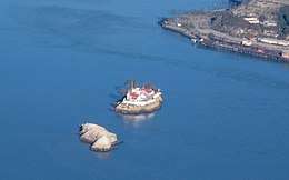
The Brothers (San Francisco Bay)
 Aerial photo of The Brothers | |
 The Brothers  The Brothers  The Brothers | |
| Geography | |
|---|---|
| Coordinates | 37°57′48″N 122°25′59″W / 37.96333°N 122.43306°W[1]Coordinates: 37°57′48″N 122°25′59″W / 37.96333°N 122.43306°W[2] |
| Administration | |
| State | California |
| County | Contra Costa County, California |
.JPG)
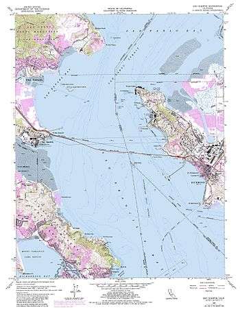
The Brothers are a pair of small islands, East Brother and West Brother, located in the San Rafael Bay embayment of San Pablo Bay, roughly 1,000 feet (300 m) west of Point San Pablo in Contra Costa County, California.
History
The 19th century Mexican Diseño del Rancho de San Pablo, (diseño: a plat map typically used to indicate rancho land grant boundaries in Alta California), names East Brother Island as Isla de Pajaros or "Bird Island."
The Brothers, along with The Sisters (two exposed rocks two miles (3.2 kilometres) north of the Marin Islands, just off Point San Pedro) on the opposite side of San Pablo Strait, were originally reserved for military purposes by order of President Andrew Johnson in 1867. After many a court battle, the plans were scrapped.[3]
East Brother Island is home to the East Brother Island Light, a light house and a Victorian house that are a present-day bed and breakfast inn.
See also
- Islands of San Francisco Bay
- List of islands of California
References
External links
