Dumbarton Bridge (California)
| Dumbarton Bridge | |
|---|---|
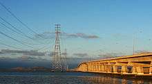 The Dumbarton Bridge and its adjacent powerline towers | |
| Coordinates | 37°30′25″N 122°07′01″W / 37.5069°N 122.1169°WCoordinates: 37°30′25″N 122°07′01″W / 37.5069°N 122.1169°W |
| Carries |
6 lanes of |
| Crosses | San Francisco Bay |
| Locale | Menlo Park, California and Fremont, California |
| Owner | State of California |
| Maintained by | California Department of Transportation and the Bay Area Toll Authority |
| Characteristics | |
| Design | Twin Concrete Girder Bridge |
| Total length | 2,621.28 meters (8,600.0 feet), 1.63 miles |
| Longest span | 103.63 meters (340.0 feet) |
| Clearance below | 25.91 meters (85.0 feet) (main span) |
| History | |
| Opened | December 1984 |
| Statistics | |
| Daily traffic |
81,000 (auto) 118 (bike & pedestrian) |
| Toll |
Cars (westbound only) $5.00 (cash or FasTrak), $2.50 (carpools during peak hours, FasTrak only) |
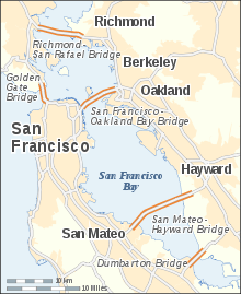 Dumbarton Bridge crosses the Southern portion of San Francisco Bay | |
The Dumbarton Bridge is the southernmost of the highway bridges across San Francisco Bay in California. Carrying over 81,000 vehicles and about 118 pedestrian and bicycle crossings daily,[1] it is the shortest bridge across San Francisco Bay at 1.63 miles (8,600 ft; 2,620 m). Its eastern end is in Fremont, near Newark in the San Francisco Bay National Wildlife Refuge, and its western end is in Menlo Park. Bridging State Route 84 across the bay, it has three lanes each way and a separated bike/pedestrian lane along its south side. Like the San Mateo Bridge to the north, power lines parallel the bridge.
History and engineering features
The bridge has never been officially named, but its commonly used name comes from Dumbarton Point, named in 1876 after Dumbarton, Scotland. Built originally to provide a shortcut for traffic originating in San Mateo and Santa Clara counties, the bridge served industrial and residential areas on both sides. The earlier bridge opened on January 17, 1927 and was the first vehicular bridge to cross San Francisco Bay. A portion of this old drawbridge remains as a fishing pier on the east side of the Bay. The original bridge was built with private capital and then purchased by the state for $2.5 million in 1951.
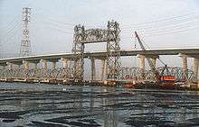
Its age and the two-lane undivided roadway and lift-span led to a replacement bridge, built to the north. This bridge opened in October 1982 as a four-lane, high-level structure. The structure was re-striped to accommodate six lanes on October 18, 1989 in response to the temporary closing of the San Francisco–Oakland Bay Bridge due to the Loma Prieta earthquake, and the permanent widening of the approaches was completed by July 2003.[2] The cost of the complete replacement project was $200 million. The current bridge includes a two-way bicycle and separate pedestrian path on the south-facing side. A 340 ft (104 m) center span provides 85 ft (26 m) of vertical clearance for shipping. The approach spans on both sides of the Bay are of pre-stressed lightweight concrete girders supporting a lightweight concrete deck. The center spans are twin steel trapezoidal girders which also support a lightweight concrete deck. In 1970 the movie Harold and Maude was filmed at the toll plaza and showed Maude speeding and disobeying a police officer.
The center span of the original bridge was demolished in a controlled explosion in September 1984.
Roadway Connections
The bridge is part of State Route 84, and is directly connected to Interstate 880 by a freeway segment north of the Fremont end. There is no freeway connection between U.S. 101 and the southwest end of the Dumbarton Bridge. Motorists must traverse one of three at-grade routes to connect from the Bayshore Freeway to the bridge. These are (from northwest to southeast):
- the Bayfront Expressway, a limited-access road linking to U.S. 101 at Marsh Road, Atherton (the official routing of SR 84)
- Willow Road (SR 114), an approximately one-mile expressway through east Menlo Park to U.S. 101
- University Avenue (SR 109), an arterial road and the main commercial street of East Palo Alto.
The Willow Road and University Avenue junctions with Bayfront Expressway are at-grade intersections controlled by traffic lights; there are two additional controlled intersections at Chilco Road and Marsh Road, and the Marsh Road interchange on U.S. 101 is a parclo. The result is that Bayfront Expressway is frequently congested, and when not congested is often the site of high-speed car crashes. In 2007, prominent author David Halberstam was killed in one such crash at the Willow Road intersection.
Access to I-280 is available via State Route 84 to Woodside Road (as signed) or other arterial routes. There are no cross-Peninsula freeway connections between State Routes 92 and 85 (which is so far south that it technically lies in Silicon Valley and not on the Peninsula). In addition, there are no direct cross-Peninsula arterial routes between State Route 84 and Page Mill Road, a five-mile gap.
Although the present situation has resulted in severe traffic problems on the bridge itself and in Menlo Park and East Palo Alto, Caltrans has been unable to upgrade the relevant portion of Highway 84 to freeway standards for several decades, due to opposition from the cities of Menlo Park, Atherton and Palo Alto. Freeway opponents fear that upgrading Highway 84 will encourage more people to live in southern Alameda County (where housing is more affordable) and commute to jobs in the mid-Peninsula area (where businesses wish to be located in order to be close to Silicon Valley), thus increasing traffic in their neighborhoods to the south and west of U.S. 101.
Bus service across the bridge is provided by the Dumbarton Express, run by a consortium of local transit agencies (SamTrans, AC Transit, VTA and others) which connects to BART at Union City and Caltrain at Palo Alto and California Avenue. AC Transit also runs Transbay buses U (Fremont BART and Amtrak to Stanford) and DA (Ardenwood to Oracle and Facebook headquarters) across the bridge. The free Stanford Marguerite Shuttle also runs buses AE-F and EB across the bridge.
Environmental factors
When the current bridge was planned in the 1970s, Caltrans conducted extensive environmental research on the aquatic and terrestrial environment. Principal concerns of the public were air pollution and noise pollution impacts, particularly in some residential areas of Menlo Park and East Palo Alto. Studies were conducted to produce contour maps of projected sound levels and carbon monoxide concentrations throughout the western approaches, for each alternative connection scheme.[3]
The area around the bridge is an important ecological area, hosting many species of birds, fish and mammals. The endangered species California clapper rail is known to be present in the western bridge terminus area.
Near the bridge on the Peninsula are Menlo Park's Bayfront Park, East Palo Alto's Ravenswood Open Space Preserve, and the Palo Alto Baylands Nature Preserve. An accessible portion of the San Francisco Bay National Wildlife Refuge lies immediately north of the western bridge terminus, where the Ravenswood trail runs.[4]
On both sides of the east end of the bridge are large salt ponds and levee trails belonging to the Don Edwards San Francisco Bay National Wildlife Refuge. The headquarters and visitor center for the refuge is on a hill south of the bridge approach. North of the east end of the bridge is Coyote Hills Regional Park, with its network of trails running over tall hills. North of that is the Alameda Creek Regional Trail from the Bay to Niles Canyon. East of Coyote Hills is Ardenwood Historic Farm, a restored working farm that preserves and displays turn-of-the-century farming methods
Tolls
Tolls are only collected from westbound traffic at the toll plaza on the east side of the bay. Since July 2010, the toll rate for passenger cars is $5.[5][6] For vehicles with more than two axles, the toll rate is $5 per axle.[7] Drivers may either pay by cash or use the FasTrak electronic toll collection device. There are seven toll lanes at the plaza. During peak traffic hours, the leftmost lane is designated a FasTrak-only HOV lane, allowing carpool vehicles carrying two or more people or motorcycles to pass for a toll of $2.50. The next two leftmost lanes are FasTrak-only lanes for all vehicles, and all other lanes accept both cash and FasTrak. During non-peak hours the HOV lane is open to vehicles carrying only one person, but remains FasTrak-only.
Historical toll rates
Prior to 1969, tolls on the Dumbarton Bridge were collected in both directions. When it opened, the original 1927 span had a toll of $0.40 per car plus $0.05 per passenger. In 1959, tolls were set to $0.35 per car. It was raised to $0.70 in 1969, then $0.75 in 1976. The toll per car remained at $0.75 when the replacement bridge opened in the 1980s.[8]
The basic toll (for automobiles) on the seven state-owned bridges, including the Dumbarton Bridge, was raised to $1 by Regional Measure 1, approved by Bay Area voters in 1988.[9] A $1 seismic retrofit surcharge was added in 1998 by the state legislature, originally for eight years, but since then extended to December 2037 (AB1171, October 2001).[10] On March 2, 2004, voters approved Regional Measure 2, raising the toll by another dollar to a total of $3. An additional dollar was added to the toll starting January 1, 2007, to cover cost overruns concerning the replacement of the eastern span.
The Metropolitan Transportation Commission, a regional transportation agency, in its capacity as the Bay Area Toll Authority, administers RM1 and RM2 funds, a significant portion of which are allocated to public transit capital improvements and operating subsidies in the transportation corridors served by the bridges. Caltrans administers the "second dollar" seismic surcharge, and receives some of the MTC-administered funds to perform other maintenance work on the bridges. The Bay Area Toll Authority is made up of appointed officials put in place by various city and county governments, and is not subject to direct voter oversight.[11]
Due to further funding shortages for seismic retrofit projects, the Bay Area Toll Authority again raised tolls on all seven of the state-owned bridges in July 2010. The toll rate for autos on the Dumbarton Bridge was thus increased to $5.[12]
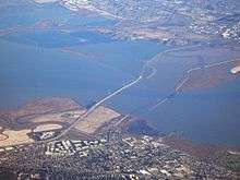
Dumbarton Rail Bridge
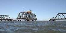
Just to the south of the car bridge lies the Dumbarton Rail Bridge. Built in 1910, the rail bridge has been unused since 1982 and its western approach collapsed in a fire in 1998.[13] When the bridge was in use, boaters would signal the operator, who would start a diesel engine and rotate the bridge to the open position on a large gear. The bridge is now left in the open position as shown. There are plans for a new rail bridge and rehabilitation of the rail line to serve a commuter rail service to connect Union City, Fremont, and Newark to various Peninsula destinations.[14] A successful March 2004 regional transportation ballot measure included funding to rehabilitate the rail bridge for the commuter rail service, but in October 2008 the Metropolitan Transportation Commission transferred $91 million from this project to the BART Warm Springs Extension Project in Fremont.[15]
Hetch Hetchy Aqueduct
Between the Dumbarton Bridge and the Dumbarton Rail Bridge is the Bay crossing of the Hetch Hetchy Aqueduct. The aqueduct rises above ground in Newark at the east side of the Bay, falls below the water's surface at a pump station in Fremont, re-emerges in the middle of the Bay and then continues above water until it reaches the west side of the Bay at Menlo Park.[16]
References
- ↑ Spotswood, Dick (8 May 2018). "Dick Spotswood: Richmond bridge third lane is working, but more needs to be done". Marin Independent Journal. Retrieved 9 May 2018.
- ↑ "Dumbarton Bridge" "Archived copy". Archived from the original on 2012-02-21. Retrieved 2012-02-28.
- ↑ C.M. Hogan, Leda Patmore, Harry Seidman et al., Air Quality and Acoustics Analysis for the Dumbarton Bridge Replacement Project, ESL Inc., prepared for the Bay Area Division of Toll Crossings (1973)
- ↑ San Francisco Bay Shoreline Guide, by California State Coastal Conservancy, University of California Press (1995) ISBN 0-520-08878-6
- ↑ "Frequently Asked Toll Questions". Bay Area Toll Authority. 2010-06-01. Archived from the original on 2010-11-01. Retrieved 2010-06-29.
- ↑ "Toll Increase Information". Bay Area Toll Authority. 2010-06-01. Archived from the original on 2010-11-01. Retrieved 2010-06-29.
- ↑ "Toll Increase Information: Multi-Axle Vehicles". Bay Area Toll Authority. 2012-07-01. Archived from the original on 2013-12-30. Retrieved 2013-12-29.
- ↑ "History of California's Bridge Tolls" (PDF). Caltrans. Retrieved June 3, 2018.
- ↑ Regional Measure 1 Toll Bridge Program. bata.mtc.ca.gov; Bay Area Toll Authority. Archived November 1, 2010, at WebCite
- ↑ Dutra, John (October 14, 2001). "AB 1171 Assembly Bill – Chaptered". California State Assembly. Archived from the original on November 1, 2010. Retrieved August 7, 2008.
- ↑ "About MTC". Metropolitan Transportation Commission. October 15, 2009. Archived from the original on November 1, 2010. Retrieved October 15, 2009.
- ↑ "Frequently Asked Toll Questions". Bay Area Toll Authority. June 1, 2010. Archived from the original on November 1, 2010. Retrieved June 29, 2010.
- ↑ Kazak, Don (1998-01-07). "FIREFIGHTERS: Dumbarton rail bridge destroyed". Paloaltoonline.com. Archived from the original on 2004-08-14. Retrieved 2015-05-25.
- ↑ "Dumbarton Rail Corridor". SMCTA. 2011-05-24. Retrieved 2011-08-21.
- ↑ "BART's Warm Springs Extension Gets Boost From Regional Measure 2 Cash". Healthcare Finance, Tax & Law Weekly. October 8, 2008. Retrieved 2009-08-02.
- ↑ Ronald Horii. "Dumbarton Bridge". Baytrail.abag.ca.gov. Archived from the original on 2011-08-07. Retrieved 2011-08-21.
External links
- California Dept. of Transportation: Dumbarton Bridge
- Bay Trail: Dumbarton Bridge
- Dumbarton Bridge at Structurae

San Mateo County, California, United States | ||
| Primary and secondary schools | ||
| Colleges and universities | ||
| Landmarks | ||
| Historic Places | ||
| Transportation | ||
| Commercial centers | ||
| Healthcare | ||
Crossings of the San Francisco Bay | ||||
|---|---|---|---|---|
| ||||