Turretot
Turretot is a commune in the Seine-Maritime department in the Normandy region in northern France.
Turretot | |
|---|---|
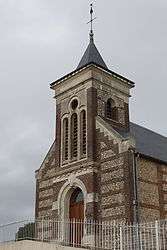 The church in Turretot | |
.svg.png) Coat of arms | |
Location of Turretot 
| |
 Turretot  Turretot | |
| Coordinates: 49°36′29″N 0°13′41″E | |
| Country | France |
| Region | Normandy |
| Department | Seine-Maritime |
| Arrondissement | Le Havre |
| Canton | Octeville-sur-Mer |
| Intercommunality | Le Havre Seine Métropole |
| Government | |
| • Mayor | Bernard Houssaye |
| Area 1 | 6.07 km2 (2.34 sq mi) |
| Population (2017-01-01)[1] | 1,469 |
| • Density | 240/km2 (630/sq mi) |
| Time zone | UTC+01:00 (CET) |
| • Summer (DST) | UTC+02:00 (CEST) |
| INSEE/Postal code | 76716 /76280 |
| Elevation | 70–122 m (230–400 ft) (avg. 104 m or 341 ft) |
| 1 French Land Register data, which excludes lakes, ponds, glaciers > 1 km2 (0.386 sq mi or 247 acres) and river estuaries. | |
Geography
A farming village in the Pays de Caux, situated some 12 miles (19 km) northeast of Le Havre, at the junction of the D78 and D125e roads.
Population
| Year | 1962 | 1968 | 1975 | 1982 | 1990 | 1999 | 2006 |
|---|---|---|---|---|---|---|---|
| Population | 273 | 284 | 587 | 1157 | 1178 | 1315 | 1466 |
| From the year 1962 on: No double counting—residents of multiple communes (e.g. students and military personnel) are counted only once. | |||||||
Places of interest
- The church of St. Anne, dating from the thirteenth century.
- The church of St. Martin, dating from the twelfth century.
External links
| Wikimedia Commons has media related to Turretot. |
- Website of the Sporting Club de Turretot (in French)
- Turretot on the Quid website (in French)
| Authority control |
|
|---|
This article is issued from Wikipedia. The text is licensed under Creative Commons - Attribution - Sharealike. Additional terms may apply for the media files.