Saint-Clair-sur-les-Monts
Saint-Clair-sur-les-Monts is a commune in the Seine-Maritime department in the Normandy region in northern France.
Saint-Clair-sur-les-Monts | |
|---|---|
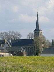 The church in Saint-Clair-sur-les-Monts | |
 Coat of arms | |
Location of Saint-Clair-sur-les-Monts 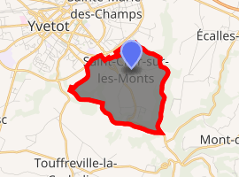
| |
 Saint-Clair-sur-les-Monts  Saint-Clair-sur-les-Monts | |
| Coordinates: 49°36′28″N 0°47′12″E | |
| Country | France |
| Region | Normandy |
| Department | Seine-Maritime |
| Arrondissement | Rouen |
| Canton | Yvetot |
| Intercommunality | Région d'Yvetot |
| Government | |
| • Mayor (2008–2014) | Mario Demazieres |
| Area 1 | 4.07 km2 (1.57 sq mi) |
| Population (2017-01-01)[1] | 591 |
| • Density | 150/km2 (380/sq mi) |
| Time zone | UTC+01:00 (CET) |
| • Summer (DST) | UTC+02:00 (CEST) |
| INSEE/Postal code | 76568 /76190 |
| Elevation | 57–142 m (187–466 ft) (avg. 125 m or 410 ft) |
| 1 French Land Register data, which excludes lakes, ponds, glaciers > 1 km2 (0.386 sq mi or 247 acres) and river estuaries. | |
Geography
A farming village situated in the Pays de Caux, some 22 miles (35 km) northwest of Rouen near the junction of the D5 and the D131e roads.
Heraldry
Arms of Saint-Clair-sur-les-Monts |
The arms of Saint-Clair-sur-les-Monts are blazoned : Argent, on a bend gules between a garb [of wheat] and a lion vert, a buckle between 2 mullets of 5 all palewise Or. |
Population
| Year | 1962 | 1968 | 1975 | 1982 | 1990 | 1999 | 2006 |
|---|---|---|---|---|---|---|---|
| Population | 257 | 291 | 285 | 411 | 484 | 560 | 657 |
| From the year 1962 on: No double counting—residents of multiple communes (e.g. students and military personnel) are counted only once. | |||||||
Places of interest

The cross
- The church of St.Clair, dating from the thirteenth century.
- A fifteenth century manorhouse.
- The 3 Châteaux (de Marseille, Mézerville and de Taillanville).
- A sixteenth-century stone cross.
References
- "Populations légales 2017". INSEE. Retrieved 6 January 2020.
| Wikimedia Commons has media related to Saint-Clair-sur-les-Monts. |
| Authority control |
|
|---|
This article is issued from Wikipedia. The text is licensed under Creative Commons - Attribution - Sharealike. Additional terms may apply for the media files.