Sainte-Geneviève, Seine-Maritime
Sainte-Geneviève (sometimes Sainte-Geneviève-en-Bray) is a commune in the Seine-Maritime department in the Normandy region in northern France.
Sainte-Geneviève | |
|---|---|
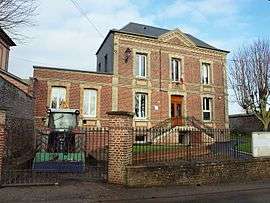 The town hall in Sainte-Geneviève | |
.svg.png) Coat of arms | |
Location of Sainte-Geneviève 
| |
 Sainte-Geneviève  Sainte-Geneviève | |
| Coordinates: 49°39′16″N 1°26′07″E | |
| Country | France |
| Region | Normandy |
| Department | Seine-Maritime |
| Arrondissement | Dieppe |
| Canton | Neufchâtel-en-Bray |
| Intercommunality | CC Bray-Eawy |
| Government | |
| • Mayor (2008–2014) | Marie-Josée Hautot |
| Area 1 | 14.33 km2 (5.53 sq mi) |
| Population (2017-01-01)[1] | 270 |
| • Density | 19/km2 (49/sq mi) |
| Time zone | UTC+01:00 (CET) |
| • Summer (DST) | UTC+02:00 (CEST) |
| INSEE/Postal code | 76578 /76440 |
| Elevation | 103–231 m (338–758 ft) (avg. 172 m or 564 ft) |
| 1 French Land Register data, which excludes lakes, ponds, glaciers > 1 km2 (0.386 sq mi or 247 acres) and river estuaries. | |
Geography
A farming village situated in the Pays de Bray, some 28 miles (45 km) southeast of Dieppe at the junction of the D1, the D83 and the D915 roads. Three small tributaries of the Béthune River have their source in the land around the commune.
Population
| 1962 | 1968 | 1975 | 1982 | 1990 | 1999 | 2006 |
|---|---|---|---|---|---|---|
| 433 | 546 | 348 | 307 | 253 | 251 | 279 |
| Starting in 1962: Population without duplicates | ||||||
Places of interest
- The church of St. Geneviève, dating from the thirteenth century.
- The chateau of Mainemare and its park.
External links
| Wikimedia Commons has media related to Sainte-Geneviève (Seine-Maritime). |
- Sainte-Geneviève on the Quid website (in French)
| Authority control |
|
|---|
This article is issued from Wikipedia. The text is licensed under Creative Commons - Attribution - Sharealike. Additional terms may apply for the media files.