Sainte-Foy, Seine-Maritime
Sainte-Foy is a commune in the Seine-Maritime department in the Normandy region in northern France.
Sainte-Foy | |
|---|---|
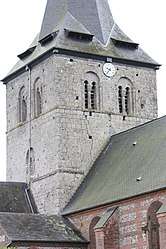 The church in Sainte-Foy | |
Location of Sainte-Foy 
| |
 Sainte-Foy  Sainte-Foy | |
| Coordinates: 49°47′47″N 1°08′10″E | |
| Country | France |
| Region | Normandy |
| Department | Seine-Maritime |
| Arrondissement | Dieppe |
| Canton | Luneray |
| Intercommunality | CC Terroir de Caux |
| Government | |
| • Mayor | Yves Levasseur |
| Area 1 | 6.72 km2 (2.59 sq mi) |
| Population (2017-01-01)[1] | 593 |
| • Density | 88/km2 (230/sq mi) |
| Time zone | UTC+01:00 (CET) |
| • Summer (DST) | UTC+02:00 (CEST) |
| INSEE/Postal code | 76577 /76590 |
| Elevation | 65–154 m (213–505 ft) (avg. 135 m or 443 ft) |
| 1 French Land Register data, which excludes lakes, ponds, glaciers > 1 km2 (0.386 sq mi or 247 acres) and river estuaries. | |
Geography
A farming village situated in the Pays de Caux, some 9 miles (14 km) south of Dieppe at the junction of the D100 and the D149 roads.
Population
| 1962 | 1968 | 1975 | 1982 | 1990 | 1999 | 2006 |
|---|---|---|---|---|---|---|
| 291 | 311 | 378 | 438 | 405 | 390 | 481 |
| Starting in 1962: Population without duplicates | ||||||
Places of interest
- The church of St. Foy, dating from the eleventh century.
- An eleventh-century chapel.
- The château and its park.
References
- "Populations légales 2017". INSEE. Retrieved 6 January 2020.
| Wikimedia Commons has media related to Sainte-Foy (Seine-Maritime). |
| Authority control |
|
|---|
This article is issued from Wikipedia. The text is licensed under Creative Commons - Attribution - Sharealike. Additional terms may apply for the media files.