Sainte-Beuve-en-Rivière
Sainte-Beuve-en-Rivière is a commune in the Seine-Maritime department in the Normandy region in northern France.
Sainte-Beuve-en-Rivière | |
|---|---|
.jpg) The church in Sainte-Beuve-en-Rivière | |
Location of Sainte-Beuve-en-Rivière 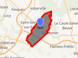
| |
 Sainte-Beuve-en-Rivière  Sainte-Beuve-en-Rivière | |
| Coordinates: 49°45′46″N 1°31′46″E | |
| Country | France |
| Region | Normandy |
| Department | Seine-Maritime |
| Arrondissement | Dieppe |
| Canton | Neufchâtel-en-Bray |
| Intercommunality | CC Bray-Eawy |
| Government | |
| • Mayor | Michèle Coffin |
| Area 1 | 11.57 km2 (4.47 sq mi) |
| Population (2017-01-01)[1] | 183 |
| • Density | 16/km2 (41/sq mi) |
| Time zone | UTC+01:00 (CET) |
| • Summer (DST) | UTC+02:00 (CEST) |
| INSEE/Postal code | 76567 /76270 |
| Elevation | 118–229 m (387–751 ft) (avg. 150 m or 490 ft) |
| 1 French Land Register data, which excludes lakes, ponds, glaciers > 1 km2 (0.386 sq mi or 247 acres) and river estuaries. | |
Geography
A forestry and farming village situated by the banks of the river Eaulne in the Pays de Bray, some 19 miles (31 km) southeast of Dieppe at the junction of the D36 and the D929 roads. The A29 autoroute passes through the south-western part of the commune's territory.
Population
| 1962 | 1968 | 1975 | 1982 | 1990 | 1999 | 2006 |
|---|---|---|---|---|---|---|
| 268 | 268 | 208 | 198 | 179 | 162 | 185 |
| Starting in 1962: Population without duplicates | ||||||
Places of interest
- The church of St. Beuve, dating from the twelfth century.
References
- "Populations légales 2017". INSEE. Retrieved 6 January 2020.
External links
| Wikimedia Commons has media related to Sainte-Beuve-en-Rivière. |
- Sainte-Beuve-en-Rivière on the Quid website (in French)
| Authority control |
|
|---|
This article is issued from Wikipedia. The text is licensed under Creative Commons - Attribution - Sharealike. Additional terms may apply for the media files.