Bernières, Seine-Maritime
Bernières is a commune in the Seine-Maritime department in the Normandy region in northern France.
Bernières | |
|---|---|
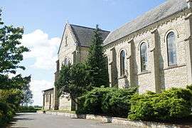 The church in Bernières | |
Location of Bernières 
| |
 Bernières  Bernières | |
| Coordinates: 49°37′16″N 0°28′43″E | |
| Country | France |
| Region | Normandy |
| Department | Seine-Maritime |
| Arrondissement | Le Havre |
| Canton | Bolbec |
| Intercommunality | CA Caux vallée de Seine |
| Area 1 | 6.63 km2 (2.56 sq mi) |
| Population (2017-01-01)[1] | 641 |
| • Density | 97/km2 (250/sq mi) |
| Time zone | UTC+01:00 (CET) |
| • Summer (DST) | UTC+02:00 (CEST) |
| INSEE/Postal code | 76082 /76210 |
| Elevation | 110–142 m (361–466 ft) (avg. 142 m or 466 ft) |
| 1 French Land Register data, which excludes lakes, ponds, glaciers > 1 km2 (0.386 sq mi or 247 acres) and river estuaries. | |
Geography
A farming village situated in the Pays de Caux, some 16 miles (26 km) northeast of Le Havre, at the junction of the D73 and the D52 roads. The A29 autoroute forms the commune's southern border.
Population
| Year | 1962 | 1968 | 1975 | 1982 | 1990 | 1999 | 2006 |
|---|---|---|---|---|---|---|---|
| Population | 428 | 471 | 572 | 549 | 578 | 544 | 626 |
| From the year 1962 on: No double counting—residents of multiple communes (e.g. students and military personnel) are counted only once. | |||||||
Places of interest
- The church of St.Jean-Baptiste, dating from the nineteenth century.
- A manorhouse
- The chateau of Durdan.
References
- "Populations légales 2017". INSEE. Retrieved 6 January 2020.
External links
| Wikimedia Commons has media related to Bernières. |
- Bernières on the Quid website (in French)
| Authority control |
|
|---|
This article is issued from Wikipedia. The text is licensed under Creative Commons - Attribution - Sharealike. Additional terms may apply for the media files.