Motteville
Motteville is a commune in the Seine-Maritime department in the Normandy region in northern France.
Motteville | |
|---|---|
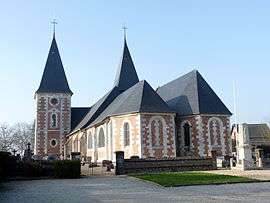 The church in Motteville | |
Location of Motteville 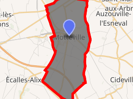
| |
 Motteville  Motteville | |
| Coordinates: 49°38′10″N 0°51′22″E | |
| Country | France |
| Region | Normandy |
| Department | Seine-Maritime |
| Arrondissement | Rouen |
| Canton | Yvetot |
| Intercommunality | CC Plateau de Caux-Doudeville-Yerville |
| Government | |
| • Mayor | Elisabeth Petit |
| Area 1 | 8.68 km2 (3.35 sq mi) |
| Population (2017-01-01)[1] | 791 |
| • Density | 91/km2 (240/sq mi) |
| Time zone | UTC+01:00 (CET) |
| • Summer (DST) | UTC+02:00 (CEST) |
| INSEE/Postal code | 76456 /76970 |
| Elevation | 135–157 m (443–515 ft) (avg. 150 m or 490 ft) |
| 1 French Land Register data, which excludes lakes, ponds, glaciers > 1 km2 (0.386 sq mi or 247 acres) and river estuaries. | |
Geography
A farming village situated in the Pays de Caux, some 22 miles (35 km) northwest of Rouen at the junction of the D20, D89, D53 and the D336 roads. SNCF operates a TER (train) train service here.
Population
| 1962 | 1968 | 1975 | 1982 | 1990 | 1999 | 2006 |
|---|---|---|---|---|---|---|
| 553 | 604 | 620 | 666 | 706 | 730 | 728 |
| Starting in 1962: Population without duplicates | ||||||
Places of interest
- The church of St.Michel, dating from the thirteenth century.
- The Château Henri IV
- The sixteenth century fortified manorhouse.
References
- "Populations légales 2017". INSEE. Retrieved 6 January 2020.
External links
| Wikimedia Commons has media related to Motteville. |
- Official website of the commune (in French)
| Authority control |
|
|---|
This article is issued from Wikipedia. The text is licensed under Creative Commons - Attribution - Sharealike. Additional terms may apply for the media files.