Roswell, New Mexico
Roswell is a city in, and the seat of, Chaves County in the U.S. state of New Mexico, the county forms the entirety of the Roswell micropolitan area.[2] As of the 2010 census it had a population of 48,411,[3] making it the fifth-largest city in New Mexico. It is home of New Mexico Military Institute (NMMI), founded in 1891. The city is also the location of an Eastern New Mexico University campus. Bitter Lake National Wildlife Refuge is located a few miles northeast of the city on the Pecos River. Bottomless Lakes State Park is located 12 miles (19 km) east of Roswell on US 380.
Roswell, New Mexico | |
|---|---|
City | |
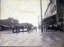
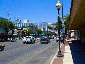 Main Street in downtown Roswell | |
 Flag Seal | |
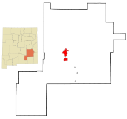 Location within Chaves County | |
 Roswell Location within New Mexico  Roswell Location within the United States | |
| Coordinates: 33°23′14″N 104°31′41″W | |
| Country | United States |
| State | New Mexico |
| County | Chaves |
| Government | |
| • Mayor | Dennis Kintigh |
| Area | |
| • Total | 29.9 sq mi (77.5 km2) |
| • Land | 29.8 sq mi (77.3 km2) |
| • Water | 0.04 sq mi (0.1 km2) |
| Elevation | 3,573 ft (1,089 m) |
| Population (2010) | |
| • Total | 48,411 |
| • Estimate (2019)[1] | 47,551 |
| • Density | 1,600/sq mi (620/km2) |
| Time zone | UTC−07:00 (Mountain) |
| • Summer (DST) | UTC−06:00 (DST) |
| ZIP Codes | 88201-88203 |
| Area code(s) | 575 |
| FIPS code | 35-64930 |
| GNIS feature ID | 0894171 |
| Website | www |
The Roswell UFO incident was named after the town, though the crash site of the alleged UFO was some 75 miles (121 km) from Roswell and closer to Corona. The investigation and debris recovery was handled by the local Roswell Army Air Field. In the 1930s, Roswell was a site for much of Robert H. Goddard's early rocketry work. The Roswell Museum and Art Center maintains an exhibit that includes a recreation of Goddard's rocket engine development workshop.
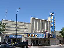
Roswell's tourism industry is based on aerospace engineering and ufology museums and businesses, as well as alien-themed and spacecraft-themed iconography. The city also relies on New Mexico and Americana related tourism. New Mexican cuisine restaurants, such as Martin's Capitol Café,[4][5][6] are located near downtown on Main Street, near the International UFO Museum and Research Center. Local American folk and New Mexico music performances occur near Pioneer Plaza and in parks around the city. It is a center for acequia-similar irrigated farming, dairying, and ranching, it also the location of several manufacturing, distribution, and petroleum related facilities. This regional pride has resulted in Roswell receiving the All-America City Award multiple times, in 1978–79 and 2002.
History

The first non-indigenous settlers of the area around Roswell were a group of pioneers from Missouri, who attempted to start a settlement 15 miles (24 km) southwest of what is now Roswell in 1865, but were forced to abandon the site because of a lack of water. It was called Missouri Plaza. It also had many Hispanic people from Lincoln, New Mexico. John Chisum had his famous Jingle Bob Ranch about 5 miles (8 km) from the center of Roswell, at South Spring Acres. At the time, it was the largest ranch in the United States.
Van C. Smith, a businessman from Omaha, Nebraska, and his partner, Aaron Wilburn, constructed two adobe buildings in 1869 that began what is now Roswell. The two buildings became the settlement's general store, post office, and sleeping quarters for paying guests. In 1871, Smith filed a claim with the federal government for the land around the buildings, and on August 20, 1873, he became the town's first postmaster. Smith was the son of Roswell Smith, a prominent lawyer in Lafayette, Indiana, and Annie Ellsworth, daughter of U.S. Patent Commissioner Henry Leavitt Ellsworth. He called the town Roswell, after his father's first name.
In 1877, Captain Joseph Calloway Lea and his family bought out Smith and Wilburn's claim and became the owners of most of the land of Roswell and the area surrounding it. The town was relatively quiet during the Lincoln County War (1877–1879). A major aquifer was discovered when merchant Nathan Jaffa had a well drilled in his back yard on Richardson Avenue in 1890, resulting in the area's first major growth and development spurt. The growth continued when a railroad was built through town in 1893.
During World War II, a prisoner-of-war camp was located in nearby Orchard Park. The German prisoners of war were used to do major infrastructure work in Roswell, such as paving the banks of the North Spring River. Some POWs used rocks of different sizes to create the outline of an iron cross among the stones covering the north bank. Later, the iron cross was covered with a thin layer of concrete. In the 1980s, a crew cleaning the river bed cleared off the concrete and revealed the outline once more. The small park just south of the cross was then known as Iron Cross Park. On November 11, 1996, the park was renamed POW/MIA Park. The park displays a piece of the Berlin Wall, presented to the city of Roswell by the German Air Force.
Roswell was a location of military importance from 1941 to 1967. In 1967, the Walker Air Force Base was decommissioned. After the closure of the base, Roswell capitalized on its pleasant climate and reinvented itself as a retirement community.
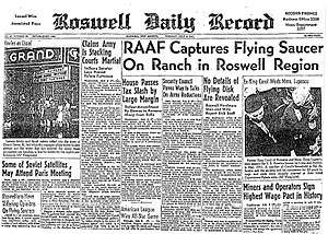
Roswell has benefited from interest in the alleged UFO incident of 1947. It was the report of an object that crashed in the general vicinity in June or July 1947, allegedly an extraterrestrial spacecraft and its alien occupants. Since the late 1970s, the incident has been the subject of intense controversy and of a conspiracy theory regarding a classified program named "Mogul". Many UFO proponents maintain that an alien craft was found and its occupants were captured, and that the military then engaged in a cover-up. In recent times, the business community has deliberately sought out tourists interested in UFOs, science fiction, and aliens.
Roswell hosted the record-breaking skydive by Felix Baumgartner on October 14, 2012.[7]
Geography
Roswell is located in southeastern New Mexico, approximately 7 mi (11 km) west of the Pecos River and some 40 mi (64 km) east of highlands that rise to the Sierra Blanca range. U.S. Routes 70, 285 and 380 intersect in the city. US 70 leads northeast 111 mi (179 km) to Clovis and 117 mi (188 km) west to Alamogordo; US 285 leads north 192 mi (309 km) to Santa Fe and south 76 mi (122 km) to Carlsbad; and US 380 leads east 134 mi (216 km) to Brownfield, Texas, and west 164 mi (264 km) to Socorro.
According to the United States Census Bureau, Roswell has a total area of 29.9 square miles (77.5 km2), of which 29.8 square miles (77.3 km2) is land and 0.04 square miles (0.1 km2), or 0.19%, is covered by water.[3]

Climate
Roswell is located in the High Plains and has four very distinct seasons, giving it a BSk or BSh semiarid climate according to the Köppen climate classification. Winters are cold, but usually sunny, and snowfall is a common occurrence. Spring is mild and usually warm, but can still be cold on occasion. Summers are hot (as is common with the High Plains of New Mexico and Colorado) and, quite frequently, the temperature rises above 100 °F, which can be unpleasant. The North American monsoon occurs during the summer, and can bring torrential downpours, severe thunderstorms (with high winds and hail) and sometimes even tornadoes. The rain can provide a cooling relief from the scorching great plains heat. Fall is mild and pleasant, but can be cold. Snow is possible in October and November.
The record low in Roswell is −24 °F (−31 °C) on January 11, 1962 and February 8, 1933.[8] The record high is 114 °F (46 °C) on June 27, 1994.[9]
| Climate data for Roswell, New Mexico (Roswell Air Park), 1981–2010 normals, extremes 1893–present | |||||||||||||
|---|---|---|---|---|---|---|---|---|---|---|---|---|---|
| Month | Jan | Feb | Mar | Apr | May | Jun | Jul | Aug | Sep | Oct | Nov | Dec | Year |
| Record high °F (°C) | 88 (31) |
88 (31) |
95 (35) |
102 (39) |
107 (42) |
114 (46) |
111 (44) |
111 (44) |
104 (40) |
99 (37) |
94 (34) |
84 (29) |
114 (46) |
| Average high °F (°C) | 55.1 (12.8) |
60.7 (15.9) |
68.3 (20.2) |
76.8 (24.9) |
85.4 (29.7) |
93.2 (34.0) |
93.7 (34.3) |
91.7 (33.2) |
85.6 (29.8) |
75.7 (24.3) |
64.3 (17.9) |
54.6 (12.6) |
75.4 (24.1) |
| Average low °F (°C) | 26.1 (−3.3) |
30.7 (−0.7) |
36.9 (2.7) |
44.7 (7.1) |
54.7 (12.6) |
63.2 (17.3) |
67.0 (19.4) |
65.8 (18.8) |
58.5 (14.7) |
46.5 (8.1) |
34.3 (1.3) |
26.1 (−3.3) |
46.2 (7.9) |
| Record low °F (°C) | −24 (−31) |
−24 (−31) |
−5 (−21) |
17 (−8) |
27 (−3) |
40 (4) |
52 (11) |
48 (9) |
30 (−1) |
14 (−10) |
−6 (−21) |
−10 (−23) |
−24 (−31) |
| Average precipitation inches (mm) | 0.38 (9.7) |
0.42 (11) |
0.51 (13) |
0.61 (15) |
1.25 (32) |
1.73 (44) |
2.06 (52) |
1.97 (50) |
1.53 (39) |
1.23 (31) |
0.58 (15) |
0.64 (16) |
12.91 (328) |
| Average snowfall inches (cm) | 3.2 (8.1) |
2.1 (5.3) |
1.2 (3.0) |
0.3 (0.76) |
0.0 (0.0) |
0.0 (0.0) |
0.0 (0.0) |
0.0 (0.0) |
0.0 (0.0) |
0.1 (0.25) |
1.3 (3.3) |
3.7 (9.4) |
11.9 (30) |
| Average precipitation days (≥ 0.01 in) | 3.4 | 3.1 | 3.3 | 2.9 | 4.4 | 5.3 | 6.9 | 8.1 | 6.0 | 5.0 | 2.8 | 3.9 | 55.1 |
| Average snowy days (≥ 0.1 in) | 2.0 | 1.0 | 0.7 | 0.3 | 0.0 | 0.0 | 0.0 | 0.0 | 0.0 | 0.2 | 0.6 | 1.8 | 6.6 |
| Average relative humidity (%) | 56.8 | 51.1 | 39.7 | 36.5 | 39.6 | 43.2 | 49.1 | 54.1 | 57.6 | 54.0 | 52.7 | 54.5 | 49.1 |
| Mean monthly sunshine hours | 217.1 | 223.0 | 280.8 | 307.6 | 342.9 | 344.7 | 327.9 | 300.9 | 262.7 | 269.6 | 214.5 | 210.3 | 3,302 |
| Percent possible sunshine | 68 | 72 | 76 | 79 | 80 | 80 | 75 | 73 | 71 | 77 | 68 | 68 | 74 |
| Source: NOAA (relative humidity 1973–1990, sun 1962–1982)[8][10][11] | |||||||||||||
Demographics
| Historical population | |||
|---|---|---|---|
| Census | Pop. | %± | |
| 1900 | 2,049 | — | |
| 1910 | 6,172 | 201.2% | |
| 1920 | 7,033 | 14.0% | |
| 1930 | 11,173 | 58.9% | |
| 1940 | 13,482 | 20.7% | |
| 1950 | 25,738 | 90.9% | |
| 1960 | 39,593 | 53.8% | |
| 1970 | 33,908 | −14.4% | |
| 1980 | 39,676 | 17.0% | |
| 1990 | 44,654 | 12.5% | |
| 2000 | 45,293 | 1.4% | |
| 2010 | 48,411 | 6.9% | |
| Est. 2019 | 47,551 | [1] | −1.8% |
| U.S. Decennial Census[12] | |||
As of the 2000 census,[13] 45,293 people, 17,068 households, and 11,742 families resided in the city. The population density was 1,565.2 people per square mile (604.3/km²). The 19,327 housing units averaged 667.9 per square mile (257.9/km²). The racial makeup of the city was 70.96% White, 2.47% African American, 1.28% Native American, 0.65% Asian, 21.29% from other races, and 3.31% from two or more races. Hispanics or Latinos of any race were 44.34% of the population.
Of the 17,069 households, 34.5% had children under the age of 18 living with them, 49.1% were married couples living together, 14.9% had a female householder with no husband present, and 31.2% were not families. About 27.1% of all households were made up of individuals, and 13.4% had someone living alone who was 65 years of age or older. The average household size was 2.58 and the average family size was 3.13.
In the city, the population was distributed as 28.5% under the age of 18, 9.9% from 18 to 24, 24.9% from 25 to 44, 20.6% from 45 to 64, and 16.0% who were 65 years of age or older. The median age was 35 years. For every 100 females, there were 93.1 males. For every 100 females age 18 and over, there were 88.7 males.
The median income for a household in the city was $27,252, and for a family was $31,724. Males had a median income of $26,554 versus $21,408 for females. The per capita income for the city was $14,589. About 18.7% of families and 22.6% of the population were below the poverty line, including 31.1% of those under age 18 and 13.8% of those age 65 or over.
Education
Public schools
- Roswell Independent School District
- Roswell Job Corps
- New Mexico Military Institute includes four-year high school and two-year associate college degree programs.
- Eastern New Mexico University – Roswell offers four-year college degree programs.
- Mountain View Middle School
- Mesa Middle School
- Sierra Middle School
- Berrendo Middle School
Private schools
- All Saints Catholic School, a pre-K through eighth-grade Catholic school
- Gateway Christian School, a pre-K through high school parochial school
- Valley Christian Academy, a first grade through high school "interdenominational Christian school" (parochial, closed 2015)
- Immanuel Lutheran School, a Junior Kindergarten through 9th grade classical school
Colleges and universities
- Eastern New Mexico University-Roswell[14] is a branch of Eastern New Mexico University (headquartered in Portales). The Roswell campus offers several certificate and associate programs. Also, bachelor's and master's programs are available via ENMU's Instructional Television System.
- New Mexico Military Institute has two-year associate college-degree programs.
Professional education
- International Law Enforcement Academy, also known as ILEA-Roswell, is an academy run by the United States federal government to train law enforcement officers from around the world in the latest law enforcement techniques.
Sports
- The Roswell Invaders play in the Pecos League of professional baseball clubs. The Invaders wear lime-green uniforms to represent the city's extraterrestrial connections. Home games are played at the Joe Bauman Ballpark.
Previously, Roswell was home to the Roswell Giants (1923), Roswell Sunshiners (1937), Roswell Rockets (1949–1956) and Roswell Pirates (1959), who played in the Panhandle-Pecos Valley League (1923), West Texas-New Mexico League (1937), Longhorn League (1949–1955), Southwestern League (1956) and Sophomore League (1959).[15]
Joe Bauman hit a minor-league record 72 home runs for the 1954 Roswell Rockets. Overall, Bauman hit .400 with 72 home runs and 224 RBI, 150 walks and 188 runs in the 1954 season. Baseball Hall of Fame inductee Willie Stargell played for the 1959 Roswell Pirates. Roswell was an affiliate of the Pittsburgh Pirates in 1959.[16][17][18]
Transportation
Airport
- Roswell International Air Center is served by American Airlines via its American Eagle regional airline affiliate.
Bus routes
- Served by Pecos Trails Transit
Major highways
- U.S. Route 70
- U.S. Route 285
- U.S. Route 380
Local industry
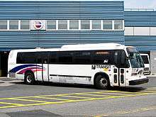
Roswell is home to Leprino Foods, one of the world's largest mozzarella factories.[19] It is also the location of the former Transportation Manufacturing Corporation factory, best known for producing various iterations of the RTS city bus since 1987. The factory was operated by Nova Bus from 1994 to 2003 and subsequently by Millennium Transit Services.
Notable residents
- Bobby Ray Baldock, U.S. federal appellate judge (Tenth Circuit Court of Appeals)
- Tom Brookshier, professional football player and sportscaster, was born in Roswell
- John Chisum, pioneer, landowner, rancher
- Louise Holland Coe, first woman elected to the New Mexico Senate, first woman to run for U.S. Congress, 1894–1985
- Max Coll, 15-term New Mexico House Representative (1966–1970, 1980–2004), grandson of James F. Hinkle
- Ray Crawford, combat pilot and auto racer, born in Roswell
- John Denver, singer and actor, born in Roswell
- Sam Donaldson, TV journalist, attended NMMI
- Pat Garrett, sheriff, killer of Billy the Kid
- Robert H. Goddard, rocket pioneer
- Susan Graham, opera singer
- James F. Hinkle, Mayor of Roswell (1904–06), New Mexico State Senator (1912–1916), Governor of New Mexico (1923–25)
- Nancy Lopez, LPGA Hall of Fame golfer
- Jody McCrea, actor, retired in Roswell
- Demi Moore, actress, born in Roswell
- Gerina Piller, professional golfer
- Clinton A. Puckett, 6th Sergeant Major of the Marine Corps, Navy Cross recipient, raised in Roswell
- James P. Riseley, Lieutenant General, USMC, retired in Roswell
- Mike E. Smith, Hall of Fame jockey, born in Roswell
- Roger Staubach, quarterback, Pro Football Hall of Famer, attended NMMI
- Austin St. John, first Red Power Ranger, born in Roswell
See also
References
- "Population and Housing Unit Estimates". Retrieved May 21, 2020.
- "Find a County". National Association of Counties. Retrieved June 7, 2011.
- "Geographic Identifiers: 2010 Demographic Profile Data (G001): Roswell city, New Mexico (revision of 01-02-2013)". U.S. Census Bureau, American Factfinder. Archived from the original on February 12, 2020. Retrieved October 16, 2014.
- "Martin's Capitol Café". Roswell Daily Record. August 4, 2017. Retrieved April 23, 2020.
- Birnes, W.J. (2010). Aliens in America: A UFO Hunter's Guide to Extraterrestrial Hotpspots Across the U.S. Adams Media. p. 184. ISBN 978-1-4405-0872-1. Retrieved April 23, 2020.
- Niederman, S. (2018). Explorer's Guide New Mexico (Third Edition) (Explorer's Complete). Explorer's Complete. Countryman Press. p. 485. ISBN 978-1-68268-191-6. Retrieved April 23, 2020.
- Llorca, Juan (October 14, 2012). "Felix Baumgartner Completes Record-Setting Jump". Huffington Post. Retrieved October 17, 2012.
- "NowData – NOAA Online Weather Data". National Oceanic and Atmospheric Administration. Retrieved June 6, 2015.
- June Daily Averages for Roswell, NM Weather.com Retrieved June 12, 2012
- "NM Roswell IND AIR PK". National Oceanic and Atmospheric Administration. Retrieved June 6, 2015.
- "WMO Climate Normals for Roswell/Industrial Air Park, NM 1961–1990". National Oceanic and Atmospheric Administration. Retrieved June 6, 2015.
- "Census of Population and Housing". Census.gov. Retrieved June 4, 2015.
- "U.S. Census website". United States Census Bureau. Retrieved January 31, 2008.
- "Eastern New Mexico University – Roswell". Eastern New Mexico University. Retrieved March 8, 2010.
- "Roswell, NM - BR Bullpen". www.baseball-reference.com.
- "Register Team Encyclopedia". Baseball-Reference.com.
- "1954 Roswell Rockets Statistics on StatsCrew.com". www.statscrew.com.
- "Roswell's Joe Bauman set home run record in 1954". MiLB.com.
- "Lots a Mozzarella in Roswell – Leprino Foods". BNET.com. 2001. Archived from the original on September 29, 2008.
- City Map, Roswell, New Mexico. Roswell: Roswell Printing, 1976.
External links
| Wikimedia Commons has media related to Roswell, New Mexico. |
| Wikivoyage has a travel guide for Roswell (New Mexico). |
Municipalities and communities of Chaves County, New Mexico, United States | ||
|---|---|---|
| City |  Map of New Mexico highlighting Chaves County | |
| Towns | ||
| CDP | ||
| Unincorporated community | ||
| Ghost town | ||
Santa Fe (capital) | ||
| Topics |
| |
| Society | ||
| Regions |
| |
| Cities | ||
| Counties | ||

| Authority control |
|
|---|