China National Highway 219
China National Highway 219 (G219) runs along the entire western and southern border of the People's Republic of China, from Kom-Kanas Mongolian Ethnic township in Xinjiang to Dongxing in Guangxi.[1] At over 10,000 kilometres (6,214 mi) long, it will be the longest National Highway, once completed.
| ||||
|---|---|---|---|---|
| 219国道 | ||||
 | ||||
| Route information | ||||
| Length | 10,000 km (10,000 mi) | |||
| Existed | 1955–present | |||
| Major junctions | ||||
| north-west end | Kom-Kanas Mongolian Ethnic township | |||
| south-east end | Dongxing | |||
| Highway system | ||||
China National Highways
| ||||
.svg.png)
Former G219
Before 2013, G219 ran from Yecheng (Karghilik) in the Xinjiang Uyghur Autonomous Region to Lhatse in the Tibet Autonomous Region. It was 2342 kilometers long.
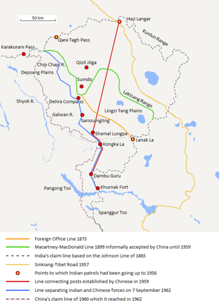
Construction of this road was started in 1951.[2] It was completed in 1957.[3] The road passes through disputed area of Aksai Chin, an area administered by the People's Republic of China but also claimed by India, and its construction was one of the triggers for the Sino-Indian War of 1962. Originally made of gravel, it was fully paved with asphalt in 2013.[4]
As one of the highest motorable roads in the world, the breathtaking scenery of Rutog County also ranks as some of the most inhospitable terrain on the planet. Domar township—a town of concrete blocks and nomad tents—is one of the bleakest and most remote outposts of the People's Liberation Army at the edge of the Aksai Chin. Near the town of Mazar many trekkers turn off for both the Karakorum range and K2 base camp. Approaching the Xinjiang border, past the final Tibetan settlement of Tserang Daban is a dangerous 5,050-meter-high pass. Tibetan nomads in the area herd both yaks and two-humped camels. Descending through the western Kunlun Shan, the road crosses additional passes of 4,000 and 3,000 meters, and the final pass offers brilliant views of the Taklamakan Desert far below before descending into the Karakax River basin.
Mountain Passes Rhyme
The western portion of the highway has numerous notable mountain passes. Motorists have invented a rhyme describing those mountain passes:[5][6]
(optional preamble) |
(optional preamble) |
Route and distance
| Route and distance | ||||||||||||||||||||||||||||||||
|
Gallery
 G219 in Barga Township, Tibet
 G219 in Burang, Tibet
 Few kilometers south of the border between Xinjiang and Tibet on the G219.
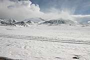 Same mountains as previous image but closer
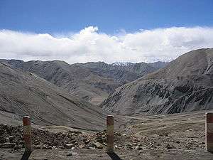 Heiqiazi Daban (Kirgizjangal Pass) in Kargilik County, Xinjiang
 Mazar Pass (Chiragsaldi Pass) in Kargilik County, Xinjiang
New route
The route was expanded in the China National Highway Network Planning (2013–2030) both northward and eastward to span the entire Chinese western and southern border. The new route will measure over 10,000 kilometres (6,214 mi), making it by far the longest National Highway.
Major cities and towns along the route are in order:
Kom-Kanas, Kaba, Jeminay County, Hoboksar, Yumin, Bole, Arixang, Zhaosu, Onsu, Uqturpan, Akqi, Peyziwat, Yopurgha, Yengisar, Yarkant, Poskam, Kargilik, Rutog (Tibet), Gar, Labrang, Saga, Gyirong, Tingri, Dinggyê County, Gamba, Lhozhag, Comai, Lhünzê , Mainling, Mêdog, Zayü, Gongshan (Yunnan), Fugong, Lushui, Tengchong, Longling, Yongde, Zhenkang, Cangyuan, Ximeng, Menglian, Lancang, Menghai, Jinghong , Jiangcheng, Luchun, Jinping, Pingbian, Maguan, Xichou, Pingxiang (Guangxi), Dongxing (border town to Vietnam).[1]
See also
References
- https://kknews.cc/zh-sg/travel/r5orq2r.html
- MemCons of Final sessions with the Chinese, White House, 1971-08-12
- 50th anniversary of Xinjiang-Tibet Highway marked Archived 2010-05-28 at the Wayback Machine, China Tibet Information Center, 2007-11-01
- Li, Ying (24 September 2014). "A road in the sky". Global Times. Retrieved 30 September 2018.
- 杨芳秀 (May 2019). "一次震撼心灵的雪山之行". The Press (in Chinese). People's Daily. ISSN 0257-5930. Retrieved 24 January 2020.
常年往来于这条路上的官兵,编了一句顺口溜来形容路上的艰辛:“库地达坂险,犹似鬼门关;麻扎达坂尖,陡升五千三;黑卡达坂旋,九十九道弯;界山达坂弯,喘气真是难。”
- 流年. 鬼藏人 (in Chinese). 知識屋. p. 1051.
- Dorje, Gyurme. (2009). Footprint Tibet Handbook. (4th Ed.) Footprint Handbooks, Bath, England. ISBN 978-1-906098-32-2.
External links
- Xinjiang-Tibet Highway (Yecheng-Burang)
- The Highway 219 from Yecheng over Western Tibet to Kathmandu Description and profile of the route.
- From Kashgar to Lhassa Photos along highway 219 (text in French).
- Some photos along the Highway 219
- A detailed description of a bicycle ride along highway 219 with lots of photos
| Radial | |
|---|---|
| North–south | |
| East–west | |
| Extended plan in 2013 under construction/renovation |
|
| Major routes (Abolished and absorbed into NTHS) | |
| Note | China National Highway 112 runs around Beijing |