Kanchanaburi Province
Kanchanaburi (Thai: กาญจนบุรี, pronounced [kāːn.t͡ɕā.ná(ʔ).bū.rīː]) is the largest of the western provinces (changwat) of Thailand. The neighboring provinces are (clockwise, from the north) Tak, Uthai Thani, Suphan Buri, Nakhon Pathom, and Ratchaburi. In the west it borders Kayin State, Mon State, and the Tanintharyi Region of Myanmar.
Kanchanaburi กาญจนบุรี | |
|---|---|
 Kanchanaburi Province montage (Clockwise from top) Three Pagodas Pass, Phra Phutta Metta Buddha Statue, Prasat Mueang Singh Castle, Bridge on the River Kwai, Srinagarind Dam, Mon Bridge, Sunken Temple of Sangklhaburi | |
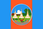 Flag 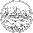 Seal | |
| Nickname(s): Mueang Kan | |
| Motto(s): "แคว้นโบราณ ด่านเจดีย์ มณีเมืองกาญจน์ สะพานข้ามแม่น้ำแคว แหล่งแร่น้ำตก" ("Ancient region, Chedi checkpoint, Manee Mueang Kan, Bridge on the River Kwai and Mineral waterfalls") | |
 Map of Thailand highlighting Kanchanaburi Province | |
| Country | Thailand |
| Capital | Kanchanaburi |
| Government | |
| • Governor | Jirakiat PhumisawaT |
| Area | |
| • Total | 19,483 km2 (7,522 sq mi) |
| Area rank | Ranked 3rd |
| Population (2018)[2] | |
| • Total | 893,151 |
| • Rank | Ranked 26th |
| • Density | 46/km2 (120/sq mi) |
| • Density rank | Ranked 74th |
| Human Achievement Index | |
| • HAI (2017) | 0.5457 "low" Ranked 67th |
| Time zone | UTC+7 (ICT) |
| Postal code | 71xxx |
| Calling code | 034 |
| ISO 3166 code | TH-71 |
| Vehicle registration | กาญจนบุรี |
| Website | www |
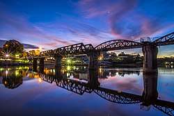
Tourists are attracted by the history of its ancient civilization and the World War II Bridge over the River Kwai, originally spelt "Khwae" but officially changed to Kwai to accommodate the expectations of tourists.
Geography
The province is in the west of Thailand, 129 km from Bangkok, and covers a total area of approximately 19,483 km². It is the country's third largest province, after Nakhon Ratchasima and Chiang Mai. Topographically, it is covered with timber and evergreen forests. The district covers the source valleys of the rivers Kwae Yai and Kwae Noi ("River Kwai"), which merge at Kanchanaburi city to form the Mae Klong River.
Bong Ti is a transnational border crossing point, which is expected to gain in importance if the planned Dawei deepwater port project goes ahead, along with a highway and a railway line between Bangkok and the port.[4]
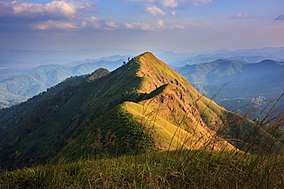
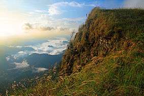
Several national parks are in the mountainous forest areas of the Tenasserim Hills of the province: the Erawan, Sai Yok, Khao Laem, Thong Pha Phum, Khuean Srinagarindra, and Chaloem Rattanakosin National Parks. The Thungyai Naresuan Wildlife Sanctuary is on the UNESCO world heritage list.
History
Archaeological remains found in Kanchanaburi date back to the 4th century, with evidence of trade with surrounding regions at that time. Very little is known about the historical Khmer influence in Kanchanaburi, but Prasat Muang Sing, one of the country's most well-known Khmer sites, provides evidence of their occupation.
Not much was historically recorded about Kanchanaburi Province before the reign of King Rama I, but some historians believe that the province was of strategic importance during the Ayutthaya period, since it was on the invasion route from Burma. In 1982, many human and elephant skeletons and swords were found in Phanom Thuan District, leading to speculation that this site might even have been the site of the famous battle of King Naresuan against the Burmese crown prince, most commonly assigned to the Don Chedi District in nearby Suphanburi Province.
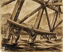
Most foreigners are mainly aware of Kanchanaburi's recent history with the Death Railway. During the Japanese occupation of Thailand in 1942, both allied POWs and Asian labourers were ordered by the Japanese to build a Thailand-Burma railway. Eventually, more than 100,000 people (16,000 allied POWs and 90,000 local Asian labourers) died from horrific working conditions.
Symbols
The seal of the province shows the three stupas on Bantadthong Mountain. They give the name to the mountain pass to Myanmar, called "Three Pagodas Pass".[5]
The provincial flower is the night-flowering jasmine (Nyctanthes arbortristis). The provincial tree is the Moulmein lancewood (Homalium tomentosum).
The provincial slogan is "A province of ancient community, three pagodas pass, precious stones, River Kwae Bridge, minerals and waterfall resources".
Administrative divisions

Provincial government
Kanchanaburi is divided into 13 districts (amphoe). The districts are further divided into 98 subdistricts (tambon) and 887 villages (muban).
Local government
As of 26 November 2019 there are[6]: one Kanchanaburi Provincial Administration Organisation (ongkan borihan suan changwat) and 49 municipal (thesaban) areas in the province. Kanchanaburi and Tha Ruea Phra Thaen have town (thesaban mueang) status. Further 47 subdistrict municipalities (thesaban tambon). The non-municipal areas are administered by 72 Subdistrict Administrative Organisations - SAO (ongkan borihan suan tambon).[2]
Transport
Kanchanaburi's main station is Kanchanaburi Railway Station.
Economy
Mining
In 1918, alluvial sapphire deposits were discovered near Bo Ploi. It was a major source of sapphires in the 1980s and 1990s.[7][8][9]
Kanchanaburi Province is the site of Klity Creek,[10] a waterway heavily polluted by the practices of the Lead Concentrate Company. The company was ordered by a Thai court to clean up its environmental damage in 2013. To date (2019) the court ordered clean-up has been halting and ineffectual.[11]
Tourism
Most of the sights in Kanchanaburi itself are directly related to WWII. The museums are dusty and generally not worth it, except for the Thailand-Burma Railway Centre, which gives a good introduction of the Burma Railway and its history. There are also two war cemeteries, the most moving of which is the Kanchanaburi War Cemetery.
National Parks
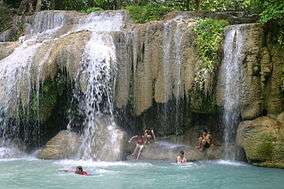
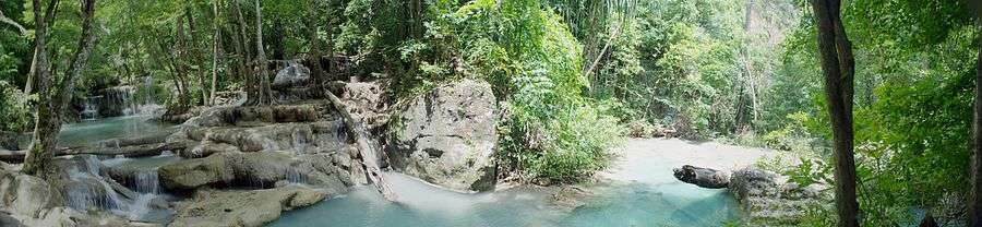
- Erawan National Park is a 550 km2 park in western Thailand in the Tenasserim Hills of Kanchanaburi Province, Amphoe Si Sawat in tambon Tha Kradan. Founded in 1975, it was Thailand's 12th national park. The major attraction of the park is Erawan Falls, a waterfall named after the erawan, the three-headed white elephant of Hindu mythology. The seven-tiered falls are said to resemble the erawan.[12] There are four caves in the park: Mi, Rua, Wang Bahdan, and Phartat.[13] Rising northeast of the waterfall area there is a breast-shaped hill named Khao Nom Nang.[14]
- Thong Pha Phum National Park is a national park. The park has numerous waterfalls and caves. Chok Kradin waterfall descends 30 metres (100 ft) over a cliff. Another large waterfall is Khao Yai, with three levels. Other park waterfalls include Dip Yai, Bi Teng and Huai Meuang. Khao Noi cave houses Buddha images. Khao Khat viewpoint offers a panoramic view over the park.[15]
- Khao Laem National Park is a park of about 1,500 square kilometers in western Thailand, located in the northern area of the Tenasserim Hills, Kanchanaburi Province. It is a part of the Western Forest Complex, a system of protected wilderness in the Dawna-Tenasserim Hills area of western Thailand. The park surrounds the Khao Laem Reservoir in Kanchanaburi province about 340 km northwest of Bangkok. It is cut through by Road 323. The vegetation consists of mixed deciduous, hill evergreen and dry evergreen forest. It is adjacent to the Thungyai Naresuan Wildlife Sanctuary, which is situated to the northeast of Khao Laem National Park. Large animals of the area include tigers, elephants, gaurs, sambar deer, barking deer and wild boars.[16]
- Sai Yok National Park is a national park in Sai Yok District. The park, home to mountains, waterfalls and caves, is part of the Western Forest Complex protected area. The park's major attractions are its waterfalls, including Sai Yok Yai waterfall which flows into the Khwae Noi river. Sai Yok Yai Lek waterfall lies south of Sai Yok Yai along the Khwae Noi.[15] The park also contains numerous caves, the largest of which is Tham Lawa with a length of 500 metres (1,600 ft). This cave complex consists of five large caverns, each containing large stalactites and stalagmites.[17] Another cave system, Tham Daowadueng, is 100 metres (330 ft) long and was discovered in 1972. Tham Daowadung consists of eight chambers of stalactites and stalagmites.[15]
Human achievement index 2017
| Health | Education | Employment | Income |
| 27 | 52 | 44 | 39 |
| Housing | Family | Transport | Participation |
 |
 |
||
| 49 | 67 | 49 | 63 |
| Province Kanchanaburi, with an HAI 2017 value of 0.5457 is "low", occupies place 67 in the ranking. | |||
Since 2003, United Nations Development Programme (UNDP) in Thailand has tracked progress on human development at sub-national level using the Human achievement index (HAI), a composite index covering all the eight key areas of human development. National Economic and Social Development Board (NESDB) has taken over this task since 2017.[3]
| Rank | Classification |
| 1 - 15 | "high" |
| 16 - 30 | "somewhat high" |
| 31 - 45 | "average" |
| 45 - 60 | "somewhat low" |
| 61 - 77 | "low" |
| Map with provinces and HAI 2017 rankings |
 |
Notes
Reports (data) from Thai government are "not copyrightable" (Public Domain), Copyright Act 2537 (1994), section 7.
References
- Advancing Human Development through the ASEAN Community, Thailand Human Development Report 2014, table 0:Basic Data (PDF) (Report). United Nations Development Programme (UNDP) Thailand. pp. 134–135. ISBN 978-974-680-368-7. Retrieved 17 January 2016, Data has been supplied by Land Development Department, Ministry of Agriculture and Cooperatives, at Wayback Machine.
- "รายงานสถิติจำนวนประชากรและบ้านประจำปี พ.ศ.2561" [Statistics, population and house statistics for the year 2018]. Registration Office Department of the Interior, Ministry of the Interior (in Thai). 31 December 2018. Retrieved 20 June 2019.
- Human achievement index 2017 by National Economic and Social Development Board (NESDB), pages 1-40, maps 1-9, retrieved 14 September 2019, ISBN 978-974-9769-33-1
- "Table A1-1-1a. Prospective projects in Mekong sub-region" (PDF). Archived from the original (PDF) on 2013-05-04. Retrieved 2012-12-28.
- Seals of The Provinces of Thailand
- "Number of local government organizations by province". dla.go.th. Department of Local Administration (DLA). 26 November 2019. Retrieved 10 December 2019.
2 Kanchanaburi: 1 PAO, 2 Town mun., 47 Subdistrict mun., 72 SAO.
- "Rattanachart Mining Company". Archived from the original on November 13, 2011. Retrieved 21 Sep 2012.
- "Bo Phloi Sapphire". Retrieved 21 Sep 2012.
- "Sapphires from Thailand". Archived from the original on September 2, 2012. Retrieved 21 Sep 2012.
- Klity villagers fight never-ending battle
- "Thailand: Clean Up Klity Creek". Human Rights Watch. Retrieved 11 February 2016.
- Elliot, Stephan; Cubitt, Gerald (2001). THE NATIONAL PARKS and other Wild Places of THAILAND. New Holland Publishers (UK) Ltd. pp. 32–35. ISBN 9781859748862.
- Erawan National Park Archived December 8, 2006, at the Wayback Machine
- Roadway Thailand Atlas, Groovy Map Co., Ltd. © 4/2010
- "National Parks in Thailand: Thong Pha Phum National Park" (PDF). Department of National Parks (Thailand). 2015. p. 204. Retrieved 26 June 2017.
- Elliot, Stephan; Cubitt, Gerald (2001). THE NATIONAL PARKS and other Wild Places of THAILAND. New Holland Publishers (UK) Ltd. pp. 42–44. ISBN 9781859748862.
- Williams, China; Beales, Mark; Bewer, Tim (February 2012). Lonely Planet Thailand (14th ed.). Lonely Planet Publications. pp. 184. ISBN 978-1-74179-714-5.
External links
| Wikimedia Commons has media related to Kanchanaburi Province. |

- Tourist Authority of Thailand
- Website of province (Thai only)
- Kanchanaburi Rajabhat University Main University in Kanchanaburi
- Erawan National Park, Kanchanaburi
Places adjacent to Kanchanaburi Province | ||||||||||
|---|---|---|---|---|---|---|---|---|---|---|
| ||||||||||