Yasothon Province
Yasothon (Thai: ยโสธร, pronounced [já.sǒː.tʰɔ̄ːn]) is one of Thailand's seventy-six provinces (changwat) lies in central northeastern Thailand also called Isan. The province was established by the revolutionary council of Field Marshal Thanom Kittikachorn, after its Announcement No. 70 which came into force on 3 March 1972.
Yasothon ยโสธร | |
|---|---|
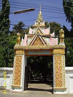 Gate of Wat Singh Tha, a part of Ban Singh Tha | |
 Flag  Seal | |
| Nickname(s): Mueang Yot | |
 Map of Thailand highlighting Yasothon Province | |
| Country | Thailand |
| Capital | Yasothon |
| Government | |
| • Governor | Prasert Luechathanon (since October 2019)[1] |
| Area | |
| • Total | 4,162 km2 (1,607 sq mi) |
| Area rank | Ranked 54th |
| Population (2018)[3] | |
| • Total | 538,729 |
| • Rank | Ranked 48th |
| • Density | 130/km2 (300/sq mi) |
| • Density rank | Ranked 37th |
| Human Achievement Index | |
| • HAI (2017) | 0.5790 "somewhat low" Ranked 46th |
| Time zone | UTC+7 (ICT) |
| Postal code | 35xxx |
| Calling code | 045 |
| ISO 3166 code | TH-35 |
| Website | www |
Neighboring provinces are (from north clockwise) Mukdahan, Amnat Charoen, Ubon Ratchathani, Sisaket, and Roi Et.
Geography
The northern part of the province are plains with low hills, while the southern part is the river lowland of the River Chi, with ponds and swamps.
Geology
Yasothon soils (rhodic ferralsols,) formed in the Triassic before the uplift of the Khorat Plateau, are relict soils made fertile by field termites through bioturbation.[5]
Climate
Yasothon has three seasons, namely summer, rainy season (mansoon) and winter. Maximum temperature is 43°C (109.4°F) and minimum temperature is 11°C (51.8°F). Average relative humidity is 71.1%. Average rainfall for the years 2009-2013 is 1,600 millimeter per year.[6]
History
The province was created on 1 March 1972, when it was split off from Ubon Ratchathani Province.
Symbols
The seal of the province shows two mythical lions, called singh, facing the chedi Pra A-non, in the temple Wat Maha That in the city of Yasothon. In the legendary account of the founding of the city, a lion came out of the forest when the site was chosen; hence the city was called Ban Singh Tha (Thai: บ้านสิงห์ท่า), Home (of) Imposing Lion. (For facts behind the legend, and of two men called Singh, see the city's history).
At the bottom of the seal is a lotus flower (Nymphaea lotus), as the lotus is both the provincial flower of the province and of Ubon Ratchathani Province, of which Yasothon was part until 1972. The provincial tree is Anisoptera costata.
Administrative divisions

Provincial government
The province is divided into nine districts (amphoe). The districts are further subdivided into 78 subdistricts (tambon) and 885 villages (muban).
|
|
Local government
As of 26 November 2019 there are[7]: one Yasothon Provincial Administration Organisation (ongkan borihan suan changwat) and 24 municipal (thesaban) areas in the province. Yasothon has town (thesaban mueang) status.[8] Further 23 subdistrict municipalities (thesaban tambon). The non-municipal areas are administered by 63 Subdistrict Administrative Organisations - SAO (ongkan borihan suan tambon).[3]
Transport

Yasothon is about 500 km (310 mi) from Bangkok at the intersection of Highways of Thailand Routes 23 and 202, and the southern end of Route 2169. Pedicabs serve the city. Tuk-tuks are prohibited. Motorcycle taxis with yellow license plates and drivers with identifying vests serve outlying areas and may take passengers about within the city limits. Several bus lines connect daily and at frequent intervals to Bangkok's Northern Bus Terminal (often called Mo Chit Mai หมอชิดใหม่) and the North Pattaya Terminal, as well as all bus terminals in the north and northeast. Train and air services connect Bangkok to Ubon Ratchathani Province, 100 kilometres east on Route 23. Yasothon's bus terminal re-located from the city centre to the Route 23 Bypass just east of the Ban Kham Noi Junction with Vittaya Thamrong Road/Rural Road YS-2018.
Human achievement index 2017
| Health | Education | Employment | Income |
| 61 | 54 | 14 | 70 |
| Housing | Family | Transport | Participation |
 |
 |
||
| 8 | 23 | 38 | 45 |
| Province Yasothon, with an HAI 2017 value of 0.5790 is "somewhat low", occupies place 46 in the ranking. | |||
Since 2003, United Nations Development Programme (UNDP) in Thailand has tracked progress on human development at sub-national level using the Human achievement index (HAI), a composite index covering all the eight key areas of human development. National Economic and Social Development Board (NESDB) has taken over this task since 2017.[4]
| Rank | Classification |
| 1 - 15 | "high" |
| 16 - 30 | "somewhat high" |
| 31 - 45 | "average" |
| 45 - 60 | "somewhat low" |
| 61 - 77 | "low" |
| Map with provinces and HAI 2017 rankings |
 |
Notes
Reports (data) from Thai government are "not copyrightable" (Public Domain), Copyright Act 2537 (1994), section 7.
References
- "ประกาศสำนักนายกรัฐมนตรี เรื่อง แต่งตั้งข้าราชการพลเรือนสามัญ" [Announcement of the Prime Minister's Office regarding the appointment of civil servants] (PDF). Royal Thai Government Gazette. 136 (Special 242 Ngor). 19. 28 September 2019. Retrieved 24 November 2019.
- Advancing Human Development through the ASEAN Community, Thailand Human Development Report 2014, table 0:Basic Data (PDF) (Report). United Nations Development Programme (UNDP) Thailand. pp. 134–135. ISBN 978-974-680-368-7. Retrieved 17 January 2016, Data has been supplied by Land Development Department, Ministry of Agriculture and Cooperatives, at Wayback Machine.
- "รายงานสถิติจำนวนประชากรและบ้านประจำปี พ.ศ.2561" [Statistics, population and house statistics for the year 2018]. Registration Office Department of the Interior, Ministry of the Interior (in Thai). 31 December 2018. Retrieved 20 June 2019.
- Human achievement index 2017 by National Economic and Social Development Board (NESDB), pages 1-40, maps 1-9, retrieved 14 September 2019, ISBN 978-974-9769-33-1
- Lofjle & Kubiniok, Landform development and bioturbation on the Khorat plateau, Northeast Thailand, Nat.Hist.Bull.Siam Soc. (56), 1996 Archived 2011-07-21 at the Wayback Machine
- "Topographical and climatic characteristics". Provincial government Yasothon. yasothon.go.th. 2019. Retrieved 10 December 2019.
- "Number of local government organizations by province". dla.go.th. Department of Local Administration (DLA). 26 November 2019. Retrieved 10 December 2019.
46 Yasothon: 1 PAO, 1 Town mun., 23 Subdistrict mun., 63 SAO.
- "พระราชกฤษฎีกา เปลียนแปลงฐานะเทศบาลตำบลยโสธรเป็นเทศบาลเมืองยโสธร พ.ศ.๒๕๓๗" [Royal Decree Re: Change the status of Yasothon Subdistrict Municipality to Yasothon Town Municipality B.E.2537 (1994)] (PDF). Royal Thai Government Gazette. 111 (52 Kor): 46–47. 23 November 1994. Retrieved 10 December 2019.
External links

- Provincial page from the Tourist Authority of Thailand
- Website of province (Thai only)
- Yasothon provincial map, coat of arms and postal stamp
| Wikisource has original text related to this article: |
Places adjacent to Yasothon Province | |
|---|---|