Dan Makham Tia District
Dan Makham Tia (Thai: ด่านมะขามเตี้ย, pronounced [dàːn mā.kʰǎːm tîa̯]) is a district (amphoe) in the southern part of Kanchanaburi Province, central Thailand.
Dan Makham Tia ด่านมะขามเตี้ย | |
|---|---|
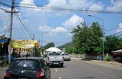 Dan Makham Tia main street. | |
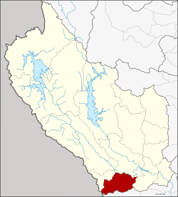 District location in Kanchanaburi Province | |
| Coordinates: 13°51′13″N 99°24′38″E | |
| Country | Thailand |
| Province | Kanchanaburi |
| Seat | Dan Makham Tia |
| Area | |
| • Total | 807.1 km2 (311.6 sq mi) |
| Population (2005) | |
| • Total | 32,248 |
| • Density | 40.0/km2 (104/sq mi) |
| Time zone | UTC+7 (ICT) |
| Postal code | 71260 |
| Geocode | 7111 |
History
The area of Dan Makham Tia was settled more than 200 years. It was a border village of Mueang Kanchanaburi adjacent to Burma.
The area had a short Makham tree (Tamarindus indica), so people called the village Ban Nong Makham Tia. Later was changed to be Dan Makham Tia.
The minor district (king amphoe) was created on 1 April 1990 by splitting off the three tambons Dan Makham Tia, Klondo, and Chorakhe Phueak from Mueang Kanchanaburi District.[1] It was upgraded to a full district on 8 September 1995.[2]
Geography
Neighboring districts are (from the north clockwise) Mueang Kanchanaburi, Tha Muang of Kanchanaburi Province, Chom Bueng and Suan Phueng of Ratchaburi Province.
The most important water resources in the area are the Khwae Noi and Phachi River.
Administration
The district is divided into four sub-districts (tambons), which are further subdivided into 39 villages (mubans'). Dan Makham Tia is a township (thesaban tambon) which covers parts of tambon Dan Makham Tia. There are a further four tambon administrative organizations (TAO).
| No. | Name | Thai name | Villages | Pop. | |
|---|---|---|---|---|---|
| 1. | Dan Makham Tia | ด่านมะขามเตี้ย | 12 | 10,205 | |
| 2. | Klondo | กลอนโด | 11 | 8,032 | |
| 3. | Chorakhe Phueak | จรเข้เผือก | 10 | 10,158 | |
| 4. | Nong Phai | หนองไผ่ | 6 | 3,853 |
References
- ประกาศกระทรวงมหาดไทย เรื่อง แบ่งเขตท้องที่อำเภอเมืองกาญจนบุรี จังหวัดกาญจนบุรี ตั้งเป็นกิ่งอำเภอด่านมะขามเตี้ย (PDF). Royal Gazette (in Thai). 103 (25 ง): 1347. February 13, 1990.
- พระราชกฤษฎีกาตั้งอำเภอด่านมะขามเตี้ย อำเภอแก่งหางแมว อำเภอภักดีชุมพล อำเภอเวียงแก่น อำเภอแม่วาง อำเภอถ้ำพรรณรา อำเภอบ่อเกลือ อำเภอโนนสุวรรณ อำเภอห้วยราช อำเภอแม่ลาน อำเภอบางแก้ว อำเภอป่าพะยอม อำเภอหนองม่วงไข่ อำเภอยางสีสุราช อำเภอจังหาร อำเภอบ้านธิ อำเภอภูสิงห์ อำเภอบางกล่ำ อำเภอวังม่วง และอำเภอนายูง พ.ศ. ๒๕๓๘ (PDF). Royal Gazette (in Thai). 112 (32 ก): 1–3. August 8, 1995.
External links
|  | |