Samut Prakan Province
Samut Prakan (Thai: สมุทรปราการ, pronounced [sāmùt prāːkāːn] (![]()
Samut Prakan Province สมุทรปราการ | |
|---|---|
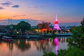 .jpg) Wat Phra Samut Chedi, Phi Sua Samut Fort | |
 Flag  Seal | |
| Nickname(s): Pak Nam Nakhon Khuean Khan | |
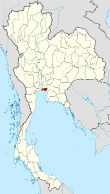 Map of Thailand highlighting Samut Prakan Province | |
| Country | Thailand |
| Capital | Mueang Samut Prakan |
| Area | |
| • Total | 1,004 km2 (388 sq mi) |
| Area rank | Ranked 71st |
| Population (2018)[2] | |
| • Total | 1,326,608 |
| • Rank | Ranked 13th |
| • Density | 1,321/km2 (3,420/sq mi) |
| • Density rank | Ranked 3rd |
| Human Achievement Index | |
| • HAI (2017) | 0.6231 "somewhat high" Ranked 17th |
| Time zone | UTC+7 (ICT) |
| Postal code | 10xxx |
| Calling code | 02 |
| ISO 3166 code | TH-11 |
| Website | www |
It is part of the Bangkok Metropolitan Region. Neighbouring provinces are Bangkok, to the north and west, and Chachoengsao to the east.
Suvarnabhumi Airport is in the Bang Phli District of Samut Prakan Province as well as the districts of Prawet, Bang Kapi and Lat Krabang in neighbouring Bangkok city.
History

The province was created during the era of the Ayutthaya Kingdom, with its administrative centre at Prapadaeng. It was the sea port of Siam, and was secured with forts, town moats, and town walls. King Rama II started building the new centre at Samut Prakan in 1819, after his predecessor King Taksin had abandoned the town fortifications. Altogether six forts were built on both sides of the Chao Phraya River, and on an island in the river the pagoda, Phra Samut Chedi, was erected. These were involved in the Paknam incident of 13 July 1893, which ended the Franco-Siamese War with a French naval blockade of Bangkok. Of the original six forts only two still exist today, Phi Sua Samut and Phra Chulachomklao.
Toponymy
In Thai the word samut is from Sanskrit, samudra, meaning 'ocean' or 'sea', and the word prakan is from Sanskrit, prākāra, meaning 'fortress', 'walls', or 'stronghold'.
Geography
Samut Prakan lies at the mouth of the Chao Phraya River on the Gulf of Thailand. Thus the province is also sometimes called Pak Nam (ปากน้ำ), Thai for 'mouth of river'. The part of the province on the west side of the river consists mostly of rice paddies and shrimp farms as well as mangrove forests, while the eastern part is the urban centre, including industrial factories. It is part of the Bangkok metropolis. The urbanization on both sides of the provincial boundary is identical. The province has a coastline of approximately 47.2 kilometres. Samut Prakan is the site of a skirmish between French and Siamese forces on 13 July 1893, subsequently referred to as the Paknam Incident. This battle resulted in a French victory and the signing of the Franco-Siamese Treaty of 3 October 1893 which ceded territory east of the Mekong River to France, territory that forms much of modern Laos.[5]
Symbols
The provincial seal shows the temple Phra Samut Chedi, the most important site of Buddhist worship in the province.
The provincial tree is Thespesia populnea.
Administrative divisions
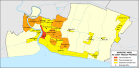
Provincial government
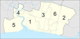
The province is divided into six districts (amphoes). The districts are further subdivided into 50 subdistricts (tambons) and 396 villages (mubans).
Local government
As of 21 November 2019 there are: one Samut Prakan Provincial Administrative Organization - PAO (ongkan borihan suan changwat) and twenty-one municipal (thesaban) areas in the province. The capital Samut Prakan has city (thesaban nakhon) status. Further six have town (thesaban mueang) status and fourteen subdistrict municipalities (thesaban tambon).[2]
| # | City municipality | 1 | Samut Prakan.[6] |
| # | Town municipalities | ||
| 1 | Praeksa Mai.[7] | 4 | Puchao Samingphrai.[8][9] |
| 2 | Paknam Samut Prakan | 5 | Lat Luang.[10] |
| 3 | Bang Kaeo[11] | 6 | Phra Pradaeng,[12] |
| # | Subdistrict municipalities | ||
| 1 | Bang Pu | 8 | Bang Phli Noi |
| 2 | Bang Mueang | 9 | Bang Bo |
| 3 | Dan Samrong | 10 | Khlong Suan |
| 4 | Samrong Nuea | 11 | Bang Phli |
| 5 | Praeksa | 12 | Laem Fapha |
| 6 | Thepharak | 13 | Phra Samut Chedi |
| 7 | Khlon Dan | 14 | Bang Sao Thong |
The non-municipal areas are administered by twenty-seven Subdistrict Administrative Organizations - SAO (ongkan borihan suan tambon). For national elections the province is divided into three voting districts, one represented by three assemblymen and the other two each by two assemblymen.
Suvarnabhumi Airport
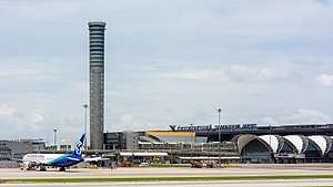
Suvarnabhumi Airport (RTGS: Suwannaphum; Thai pronunciation: [sù.wān.ná.pʰūːm][13]) (IATA: BKK, ICAO: VTBS), also known as (New) Bangkok International Airport, is one of two international airports serving Bangkok. The other one is Don Mueang International Airport.[14][15] Suvarnabhumi covers an area of 3,240 hectares (8,000 acres).
The airport is on what had formerly been known as Nong Nguhao (Cobra Swamp) in Racha Thewa in Bang Phli, Samut Prakan Province, about 25 kilometres (16 mi) east of downtown Bangkok. The terminal building was designed by Helmut Jahn of Murphy / Jahn Architects. It was constructed primarily by ITO JV. The airport has the world's tallest free-standing control tower (132.2 metres or 434 feet), and the world's fourth largest single-building airport terminal, (563,000 square metres or 6,060,000 square feet).
Suvarnabhumi is the twentieth busiest airport in the world, sixth busiest airport in Asia, and the busiest in the country, handling 63 million passengers in 2018,[16] and is also a major air cargo hub, with a total of 95 airlines. On social networks, Suvarnabhumi was the world's most popular site for taking Instagram photographs in 2012.[17]
The airport inherited the airport code, BKK, from Don Mueang after the older airport ceased international commercial flights. Motorway 7 connects the airport, Bangkok, and the heavily industrial eastern seaboard of Thailand, where most export manufacturing takes place.
Bhumibol Bridge

The Bhumibol Bridge (Thai: สะพานภูมิพล), also known as the Industrial Ring Road Bridge (Thai: สะพานวงแหวนอุตสาหกรรม) is part of the 13 km long Industrial Ring Road connecting southern Bangkok with Samut Prakan Province. The bridge crosses the Chao Phraya River twice, with two cable-stayed spans of lengths of 702 m and 582 m supported by two diamond-shaped pylons 173 m and 164 m high. Where the two spans meet, another road rises to join them at a free-flowing interchange suspended 50 metres above the ground.
The bridge opened for traffic on 20 September 2006, before the official opening date of 5 December 2006. It is part of the Bangkok Industrial Ring Road, a royal scheme initiated by King Bhumibol Adulyadej that aims to solve traffic problems within Bangkok and surrounding areas, especially the industrial area around Khlong Toei Port, Southern Bangkok, and Samut Prakan Province.
According to tradition, all the bridges over the Chao Phraya in Bangkok are named after a member of the royal family. In October 2009, it was announced that both bridges would be named after King Bhumibol Adulyadej,[18] with the northern bridge officially named "Bhumibol 1 Bridge" and the southern bridge "Bhumibol 2 Bridge".[19]
The structure of the Bhumibol Bridge consists of two parts:
- Bhumibol Bridge 1 crosses the northern part of Chao Praya River connecting Yan Nawa District, Bangkok and Song Khanong District, Samut Prakan. It is a cable-stayed bridge with seven lanes together with two high pillars. The structure is reinforced concrete 50 m above the river to enable the passage of ships.
- Bhumibol Bridge 2 is the one across the southern part of Chao Praya River connecting Song Khanong District and Bang Ya Phraek District. The structure is similar to Bhumibol Bridge 1, with seven lanes and two pillars built using reinforced concrete 50 m high.

Economy
Nissan has two factories in the district, together employing 4,000 workers, 30% of them contract workers. Nissan-Thailand has an annual production capacity of 295,000 vehicles, making the Navara, Teana, Terra, Note, Almera, March, Sylphy and X-Trail models. Nissan plans to make 190,000 vehicles by the end of its fiscal year 2019, ending next March 2020. Roughly 120,000-130,000 units are pickup trucks, the remainder passenger cars.[20] Nissan produces hybrid electric vehicles (HEVs) based on its e-Power technology and batteries for electric vehicles at a plant in Bang Sao Thong District. It has a production capacity of 370,000 vehicles a year.[21]
Thai Theparos Public Co., Ltd., a leading Thai condiment manufacturer, has its headquarters in Thai Ban Subdistrict, Mueang Samut Prakan District.[22]
Human Achievement Index 2017
| Health | Education | Employment | Income |
| 20 | 15 | 49 | 5 |
| Housing | Family | Transport | Participation |
 |
 |
||
| 69 | 1 | 7 | 77 |
| Province Samut Prakan, 2017 HAI value: 0.6231 ("somewhat high"), 17th in provincial rankings | |||
Since 2003, the United Nations Development Programme (UNDP) in Thailand has tracked progress on human development at sub-national level using the Human Achievement Index (HAI), a composite index covering eight key areas of human development. The National Economic and Social Development Board (NESDB) has taken over this task since 2017.[3]
| Rank | Classification |
| 1 - 15 | "high" |
| 16 - 30 | "somewhat high" |
| 31 - 45 | "average" |
| 45 - 60 | "somewhat low" |
| 61 - 77 | "low" |
| Map of provinces and HAI 2017 rankings |
 |
Gallery
.JPG) Lak Mueang Shrine, Phra Pradaeng
Lak Mueang Shrine, Phra Pradaeng.jpg) Wat Song Tham
Wat Song Tham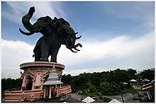 The giant three-headed statue of the elephant god Erawan
 Samut Prakan Crocodile Farm and Zoo
Notes
Reports (data) from Thai government are "not copyrightable" (Public Domain), Copyright Act 2537 (1994), section 7.
References
- Advancing Human Development through the ASEAN Community, Thailand Human Development Report 2014, table 0:Basic Data (PDF) (Report). United Nations Development Programme (UNDP) Thailand. pp. 134–135. ISBN 978-974-680-368-7. Retrieved 17 January 2016, Data has been supplied by Land Development Department, Ministry of Agriculture and Cooperatives, at Wayback Machine.
- "รายงานสถิติจำนวนประชากรและบ้านประจำปี พ.ศ.2561" [Statistics, population and house statistics for the year 2018]. Registration Office Department of the Interior, Ministry of the Interior (in Thai). 31 December 2018. Retrieved 20 June 2019.
- Human achievement index 2017 by National Economic and Social Development Board (NESDB), pages 1-40, maps 1-9, retrieved 14 September 2019, ISBN 978-974-9769-33-1
- พระราชบัญญัติจัดตั้งจังหวัดสมุทรปราการ จังหวัดนนทบุรี จังหวัดสมุทรสาคร และจังหวัดนครนายก พุทธศักราช ๒๔๘๙ [Act Establishing Changwat Samut Prakan, Changwat Nonthaburi, Changwat Samut Sakhon and Changwat Nakhon Nayok, Buddhist Era 2489 (1946)] (PDF). Royal Thai Government Gazette. 63 (29 Kor): 315–317. 9 May 1946. Retrieved 2 December 2019.
- "วันนี้ในอดีต 13 ก.ค. 2436 'วิกฤตการณ์ปากน้ำ'" [Today in the past 13 Jul 1893 'Paknam Incident']. Kom Chad Luek (in Thai). 2017-07-13. Retrieved 2020-04-19.
- "พระราชกฤษฎีกา จัดตั้งเทศบาลนครสมุทรปราการ จังหวัดสมุทรปราการ พ.ศ.๒๕๔๒" [Royal Decree Establish of Thesaban Nakhon Samut Prakan, Samut Prakan Province B.E.2542] (PDF). Royal Thai Government Gazette. 116 (19 Kor): 1–4. 23 March 1999. Retrieved 8 November 2019.
- "ประกาศกระทรวงมหาดไทย เรื่อง จัดตั้งองค์การบริหารส่วนตำบลแพรกษาใหม่ อำเภอเมืองสมุทรปราการ จังหวัดสมุทปราการ เป็นเทศบาลเมืองแพรกษาใหม่" [Notification of the Ministry of interior Re: Establishment of Praeksa Mai Subdistrict Administrative Organization, Mueang Samut Prakan district, Changwat Samut Prakan is Thesaban Mueang Praeksa Mai] (PDF). Royal Thai Government Gazette. 136 (Special 286 Ngor): 35. 21 November 2019. Retrieved 20 December 2019.
- "ประกรศกระทรวมหาดไทย เรื่อง เปลี่ยนแปลงฐานะเทศบาลตำบลสำโรงใต้ อำเภอพระประแดง จังหวัดสมุทรปราการ เป็นเทศบาลเมืองสำโรงใต้" [Notification of the Ministry of Interior change status of Thesaban Tambon Samrong Tai, Amphoe Phra Pradaeng, Changwat Samut Prakan to Thesaban Mueang Samrong Tai] (PDF). Royal Thai Government Gazette. 125 (Special 145 Ngor): 21. 1 October 2009. Retrieved 10 November 2019.
- "ประกาศกระทรวงมหาดไทย เรื่อง เปลี่ยนชื่อเทศบาลเมืองสำโรงใต้ อำเภอพระประแดง จังหวัดสมทรปราการ เป็น เทศบาลเมืองปู่เจ้าสมิงพราย" [Notification of the Ministry of Interior change name Thesaban Mueang Samrong Tai, Amphoe Phra Pradaeng, Changwat Samut Prakan to Thesaban Mueang Puchao Samingphrai] (PDF). Royal Thai Government Gazette. 127 (Special 128 Ngor): 27. 5 November 2010. Retrieved 11 November 2019.
- "พระราชฤฎีกา จัดตั้งเทศบาลเมืองลัดหลวง พ.ศ.๒๕๔๕" [Royal Decree Establishing Thesaban Mueang Lat Luang B.E.2002] (PDF). Royal Thai Government Gazette. 119 (93 Kor): 4–6. 10 September 2002. Retrieved 10 November 2019.
- "ประกาศกระทรวงมหาดไทย เรื่อง จัดตั้งองค์การบริหารส่วนตำบลบางแก้ว อำเภอบางพลี จังหวัดสมุทรปราการ เป็นเทสบาลเมืองบางแก้ว" [Notification of the Ministry of Interior change status of Bang Kaeo Subdistrict Administrative Organization, Bang Phli District, Samut Prakan Province to Bang Kaeo Mueang Municipality] (PDF). Royal Thai Government Gazette. 136 (Special 251 Ngor): 18. 9 October 2019. Retrieved 11 November 2019.
- "พระราชกฤษฎีกา จัดตั้งเทศบาลเบืองพระประแดง จังหวัดสมุทรปราการ พุทธศักราช ๒๔๘0" [Royal Decree Establishing Thesaban Mueang Phra Pradaeng, Changwat Samut Prakan Buddhist Era 2480] (PDF). Royal Thai Government Gazette. 54: 1878–1881. 14 March 1937. Retrieved 9 November 2019.
- "How to pronounce Suvarnabhumi Airport". Forvo. Retrieved 5 March 2017.
- "Don Mueang to be city budget air hub". Bangkok Post. Retrieved 2 July 2013.
- "AirAsia to shift to Don Mueang". Archived from the original on 29 October 2013. Retrieved 2 July 2013.
- Air Traffic Report 2018 (PDF). Airports of Thailand (AOT). 2019. p. 1. Retrieved 27 February 2020.
- "Suvarnabhumi, Paragon top Instagram places list". Bangkok Post, 29 December 2012.
- "Bridges Named After His Majesty". The Nation. Archived from the original on 2009-10-24. Retrieved 2012-09-19.
- "Bhumibol Bridge in Samut Prakan สะพานภูมิพล - Samut Prakan (Paknam) จังหวัดสมุทรปราการ เมืองปากน้ำ". Paknam. 2009-10-21. Archived from the original on 2012-06-25. Retrieved 2012-09-19.
- Maikaew, Piyachart (26 July 2019). "Nissan's unions unfazed by jobs cut". Bangkok Post. Retrieved 26 July 2019.
- Theparat, Chatrudee; Maikaew, Piyachart (26 July 2018). "BoI gives blessing to B30bn in plans". Bangkok Post. Retrieved 26 July 2018.
- "Contact Us". Thai Theparos Public Co., Ltd. Retrieved 29 April 2019.
External links

- Province page from the Tourist Authority of Thailand
- paknam.com - created by Sriwittayapaknam School
- Official site of the province (Thai only)
- Samut Prakan provincial map, coat of arms and postal stamp
Places adjacent to Samut Prakan Province | ||||||||||
|---|---|---|---|---|---|---|---|---|---|---|
| ||||||||||