Sa Kaeo Province
Sa Kaeo (Thai: สระแก้ว, pronounced [sàʔ kɛ̂ːw]) is one of Thailand's seventy-six province (changwat) lies in eastern Thailand about 200 km from Bangkok. Neighboring provinces are (from south clockwise) Chanthaburi, Chachoengsao, Prachinburi, Nakhon Ratchasima, and Buriram. To the east it borders Banteay Meanchey and Battambang of Cambodia.
Sa Kaeo สระแก้ว | |
|---|---|
 Countryside, Sa Kaeo Province | |
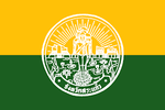 Flag 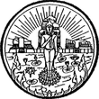 Seal | |
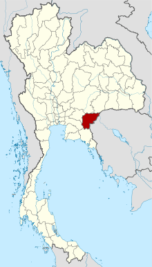 Map of Thailand highlighting Sa Kaeo Province | |
| Country | Thailand |
| Capital | Sa Kaeo town |
| Government | |
| • Governor | Woraphan Suwanun (since October 2019)[1] |
| Area | |
| • Total | 7,195 km2 (2,778 sq mi) |
| Area rank | Ranked 27th |
| Population (2018)[3] | |
| • Total | 564,092 |
| • Rank | Ranked 45th |
| • Density | 78/km2 (200/sq mi) |
| • Density rank | Ranked 64th |
| Human Achievement Index | |
| • HAI (2017) | 0.5183 "low" Ranked 73rd |
| Time zone | UTC+7 (ICT) |
| Postal code | 27xxx |
| Calling code | 037 |
| ISO 3166 code | TH-27 |
| Website | www |
History
Sa Kaeo became a province in 1993, when the six districts Sa Kaeo, Khlong Hat, Wang Nam Yen, Aranyaprathet, Ta Phraya, and Watthana Nakhon of Prachinburi were elevated to provincial status.[5] It is thus one of the four newest provinces of Thailand, together with Amnat Charoen, Nong Bua Lam Phu, and most recently, Bueng Kan.
The province is overwhelmingly Theravada Buddhist (99.4 percent).[6]
In 1979 Sa Kaeo Refugee Camp was established northwest of Sa Kaeo town. It closed in 1989, but the legacy of the border clashes of the 1970s, 1980s, and 1990s is ever present. The largest land mine field in the world was planted along the Thai-Cambodia border according to some experts. Almost 4,000 people have been injured or killed by landmines in Thailand since the border battles—19 persons in 2017 alone. According to a survey conducted in 2001, 27 of Thailand's 76 provinces were plagued with land mines, impacting more than 530 communities and some 500,000 people. Thailand still has approximately 409 km2 of mined area to clear scattered around the country. With an annual clearance rate of about one km2 between 2011 and 2015 the problem will not soon disappear.[7]
Geography
The north of the province is covered with the forested mountains of the Sankamphaeng Range and the Dangrek Mountains. To the south are the foothills of the Cardamom Mountains, which are mostly deforested.
Two national parks are found in the province: Pang Sida National Park was established in 1982, Ta Phraya National Park in 1996.
Symbols
The provincial seal shows the sun rising over archaeological ruins, Prasart Kao Noi Si Chom Poo, an important Khmer temple. The rising sun symbolizes the location of the province in the east. In the front is a Buddha image in a pond with lotus flowers.
Provincial tree is Phyllanthus emblica. The provincial flower is the Orange Jessamine (Murraya paniculata).
The provincial slogan is The frontier of the east, beautiful forests and splendid waterfalls, plenty of ancient civilisations, and the commercial venue between Thailand and Cambodia.
Administrative divisions

Provincial government
Sa Kaeo is divided into nine districts (amphoe). The districts are further divided into 59 subdistricts (tambons) and 619 villages (mubans).
Local government
As of 26 November 2019 there are[8]: one Sa Kaeo Provincial Administration Organisation (ongkan borihan suan changwat) and 16 municipal (thesaban) areas in the province. Sa Kaeo, Aranyaprathet and Wang Nam Yen have town (thesaban mueang) status. Further 13 subdistrict municipalities (thesaban tambon). The non-municipal areas are administered by 49 Subdistrict Administrative Organisations - SAO (ongkan borihan suan tambon).[3]
Human achievement index 2017
| Health | Education | Employment | Income |
| 38 | 58 | 64 | 60 |
| Housing | Family | Transport | Participation |
 |
 |
||
| 48 | 72 | 50 | 46 |
| Province Sa Kaeo, with an HAI 2017 value of 0.5183 is "low", occupies place 73 in the ranking. | |||
Since 2003, United Nations Development Programme (UNDP) in Thailand has tracked progress on human development at sub-national level using the Human achievement index (HAI), a composite index covering all the eight key areas of human development. National Economic and Social Development Board (NESDB) has taken over this task since 2017.[4]
| Rank | Classification |
| 1 - 15 | "high" |
| 16 - 30 | "somewhat high" |
| 31 - 45 | "average" |
| 45 - 60 | "somewhat low" |
| 61 - 77 | "low" |
| Map with provinces and HAI 2017 rankings |
 |
Notes
Reports (data) from Thai government are "not copyrightable" (Public Domain), Copyright Act 2537 (1994), section 7.
References
- "ประกาศสำนักนายกรัฐมนตรี เรื่อง แต่งตั้งข้าราชการพลเรือนสามัญ" [Announcement of the Prime Minister's Office regarding the appointment of civil servants] (PDF). Royal Thai Government Gazette. 136 (Special 242 Ngor). 28. 28 September 2019. Retrieved 24 November 2019.
- Advancing Human Development through the ASEAN Community, Thailand Human Development Report 2014, table 0:Basic Data (PDF) (Report). United Nations Development Programme (UNDP) Thailand. pp. 134–135. ISBN 978-974-680-368-7. Retrieved 17 January 2016, Data has been supplied by Land Development Department, Ministry of Agriculture and Cooperatives, at Wayback Machine.
- "ร่ยงานสถิติจำนวนประชากรและบ้านประจำปี พ.ศ.2561" [Statistics, population and house statistics for the year 2018]. Registration Office Department of the Interior, Ministry of the Interior. stat.bora.dopa.go.th (in Thai). 31 December 2018. Retrieved 20 June 2019.
- Human achievement index 2017 by National Economic and Social Development Board (NESDB), pages 1-40, maps 1-9, retrieved 14 September 2019, ISBN 978-974-9769-33-1
- "ABOUT SA KAEO". Tourism Authority of Thailand (TAT). Retrieved 1 May 2018.
- "Population by religion, region and area, 2015" (PDF). NSO. Retrieved 2017-10-12.
- Taylor, Caitlin (7 January 2018). "Long fight against a hidden killer". Bangkok Post (Spectrum). Retrieved 7 January 2018.
- "Number of local government organizations by province". dla.go.th. Department of Local Administration (DLA). 26 November 2019. Retrieved 10 December 2019.
63 Sa Kaeo: 1 PAO, 3 Town mun., 13 Subdistrict mun., 49 SAO.
External links

| Wikimedia Commons has media related to Sa Kaeo Province. |
Places adjacent to Sa Kaeo Province | |
|---|---|