Chaiyaphum Province
Chaiyaphum (Thai: ชัยภูมิ, pronounced [t͡ɕʰāj.jā.pʰūːm]) is one of Thailand's seventy-six provinces (changwat) lies in central northeastern Thailand also called Isan. Neighboring provinces are (from north clockwise) Khon Kaen, Nakhon Ratchasima, Lopburi, and Phetchabun.
Chaiyaphum ชัยภูมิ | |
|---|---|
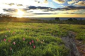
 Pa Hin Ngam National Park | |
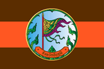 Flag  Seal | |
| Motto(s): "ชัยภูมิ เมืองผู้กล้า พญาแล" ("Chaiyaphum, Brave city and Phaya Lae") | |
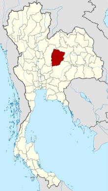 Map of Thailand highlighting Chaiyaphum Province | |
| Country | Thailand |
| Capital | Chaiyaphum town |
| Government | |
| • Governor | Narong Engsouw (since October 2017) |
| Area | |
| • Total | 12,778 km2 (4,934 sq mi) |
| Area rank | Ranked 7th |
| Population (2018)[2] | |
| • Total | 1,138,777 |
| • Rank | Ranked 19th |
| • Density | 89/km2 (230/sq mi) |
| • Density rank | Ranked 53rd |
| Human Achievement Index | |
| • HAI (2017) | 0.5744 "somewhat low" Ranked 48th |
| Time zone | UTC+7 (ICT) |
| Postal code | 36xxx |
| Calling code | 044 |
| ISO 3166 code | TH-36 |
| Website | www |
Toponymy
The word chaiya originates from the Sanskrit word jaya meaning 'victory', and the word phum from Sanskrit bhumi meaning 'earth' or 'land'. Hence the name of the province literally means 'land of victory'. The Malay/Indonesian/Sanskrit word jayabumi is equivalent.
Geography
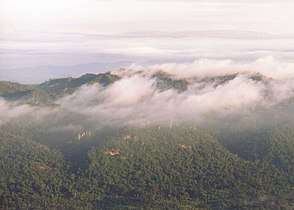
The province is bisected by the Phetchabun mountain range, with the highest elevation in the province at 1,222 m. The east of the province is part of the Khorat Plateau.
Four national parks are in the province. Tat Ton National Park is in the northwest, featuring some scenic waterfalls and dry dipterocarp forests. The biggest attraction of the Sai Thong National Park in the west is the Sai Thong waterfall, but also some fields of the Siam tulip. Similar fields can be found in the Pa Hin Ngam National Park in the southwest, scheduled to be gazetted in the future. This park's name ('beautiful rock forest') derives from the strangely-shaped rock formations found there. Phu Laenkha National Park covers 200 km2 of forested hills northwest of Chaiyaphum city.
History
The history of the city of Chaiyaphum dates back to the Khmer Empire in the 12th century, when it was a small city on the route from Angkor to Prasat Singh (Kanchanaburi Province).
In 1817 the area was settled by Lao people led by Nai Lae, an official of King Anouvong of Vientiane, which was a tributary state of the Thai monarch. They settled in Baan Nam Khun Nong E Chan in Nakhon Ratchasima Province, but soon abandoned it in favor of Ban Luang (today's city of Chaiyaphum). In 1826 Anouvong rebelled against the Thai King Rama III, seeking to gain complete independence. Nai Lae, by then made a chao praya by the Thai monarch, supported the Siamese troops. Chao Phaya Lae was killed defending his city against Anouvong's army, but Anouvong was defeated by Thai forces weeks later and Anouvong taken in chains to Bangkok. King Rama III remembered Chao Phraya Lae for his loyalty and awarded him the title Phraya Phakdi Chumpon. He is still a local hero and his statue has become a symbol of the province.
People
Most people in Chaiyaphum province are ethnically Lao. The first language of most people is the Isan language, a dialect of the Lao language.
Economy
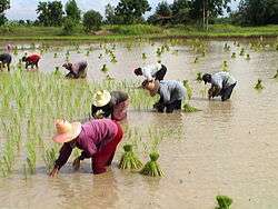
The principal crops of Chaiyaphum include rice, tapioca, sugar cane, and taro root. Chulabhorn Dam, in Thung Lui Lai Subdistrict, Khon San District is a major source of irrigation water. Due to the severe drought in 2019, the Royal Irrigation Department (RID) is proposing to build three more dams in Chaiyaphum: Wang Saphung Dam in Nong Bua Daeng District, Lam Nam Chee Dam in Ban Khwao District, and Prong Khun Petch Dam in Nong Bua Rawe District. The dams would have a combined capacity of 160 million m3 of water, which could irrigate 127,000 rai of farmland.[4]
Symbols
The provincial seal shows a triangular flag, a symbol of victory in war.
The provincial tree is Siamese senna (Cassia siamea), and the provincial flower the Siam Tulip (Curcuma alismatifolia).
The provincial slogan เมืองโบราณ บ้านนักสู้ ภูเสียดฟ้า ป่าช้างหลาย ทุ่งไพรรก น้ำตกใส ผ้าไหมดี สตรีงาม แดนธรรมแดนทอง translates to 'Enchanted city, home to heroes, mountain peaks, elephant forests, waterfalls, beautiful silk, lovely ladies, conscientious Buddhists'.
Administrative divisions
Provincial government
The province is divided into 16 districts (amphoes). The districts are further divided into 124 subdistricts (tambons) and 1393 villages (mubans).
|
|
 Map of districts |
Local government
As of 26 November 2019 there are[5]: one Chaiyaphum Provincial Administration Organisation (ongkan borihan suan changwat) and 36 municipal (thesaban) areas in the province. Chaiyaphum has town (thesaban mueang) status. Further 35 subdistrict municipalities (thesaban tambon). The non-municipal areas are administered by 106 Subdistrict Administrative Organisations - SAO (ongkan borihan suan tambon).[2]
Human achievement index 2017
| Health | Education | Employment | Income |
| 59 | 64 | 20 | 57 |
| Housing | Family | Transport | Participation |
 |
 |
||
| 13 | 22 | 63 | 39 |
| Province Chaiyphum, with an HAI 2017 value of 0.5744 is "somewhat low", occupies place 48 in the ranking. | |||
Since 2003, United Nations Development Programme (UNDP) in Thailand has tracked progress on human development at sub-national level using the Human achievement index (HAI), a composite index covering all the eight key areas of human development. National Economic and Social Development Board (NESDB) has taken over this task since 2017.[3]
| Rank | Classification |
| 1 - 15 | "high" |
| 16 - 30 | "somewhat high" |
| 31 - 45 | "average" |
| 45 - 60 | "somewhat low" |
| 61 - 77 | "low" |
| Map with provinces and HAI 2017 rankings |
 |
Gallery
 Pha Ham Hot, Sai Thong National Park
 Pha Ham Hot, Sai Thong National Park
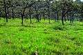 Pathumma (Curcuma alismatifolia), Sai Thong National Park
 Phu Laen Kha National Park
 Phu Laen Kha National Park
 Phu Laen Kha National Park
- Pathumma (Curcuma alismatifolia), Pa Hin Ngam National Park
See also
- Khit cloth
Notes
Reports (data) from Thai government are "not copyrightable" (Public Domain), Copyright Act 2537 (1994), section 7.
References
- Advancing Human Development through the ASEAN Community, Thailand Human Development Report 2014, table 0:Basic Data (PDF) (Report). United Nations Development Programme (UNDP) Thailand. pp. 134–135. ISBN 978-974-680-368-7. Retrieved 17 January 2016, Data has been supplied by Land Development Department, Ministry of Agriculture and Cooperatives, at Wayback Machine.
- "รายงานสถิติจำนวนประชากรและบ้านประจำปี พ.ศ.2561" [Statistics, population and house statistics for the year 2018]. Registration Office Department of the Interior, Ministry of the Interior (in Thai). 31 December 2018. Retrieved 20 June 2019.
- Human achievement index 2017 by National Economic and Social Development Board (NESDB), pages 1-40, maps 1-9, retrieved 14 September 2019, ISBN 978-974-9769-33-1
- "Water restrictions in effect". Bangkok Post. 26 December 2019. Retrieved 26 December 2019.
- "Number of local government organizations by province". dla.go.th. Department of Local Administration (DLA). 26 November 2019. Retrieved 10 December 2019.
10 Chaiyaphum: 1 PAO, 1 Town mun., 35 Subdistrict mun., 106 SAO.
External links
- https://web.archive.org/web/20100106134642/http://www.chaiyaphum.go.th/ Official website (Thai)
Places adjacent to Chaiyaphum Province | ||||||||||
|---|---|---|---|---|---|---|---|---|---|---|
| ||||||||||