Maha Sarakham Province
Maha Sarakham Province (Thai: มหาสารคาม, pronounced [mā.hǎː sǎː.rá.kʰāːm]) is one of the 76 provinces (changwat) of Thailand lies in central northeastern Thailand also called Isan. Neighbouring provinces are (from north clockwise): Kalasin, Roi Et, Surin, Buriram, and Khon Kaen.
Maha Sarakham มหาสารคาม | |
|---|---|
 Wat Kusuntararam | |
 Flag  Seal | |
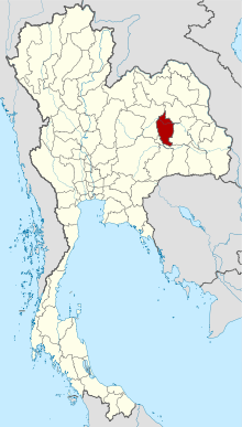 Map of Thailand highlighting Maha Sarakham Province | |
| Country | Thailand |
| Capital | Mahasarakham |
| Government | |
| • Governor | Kiatisak Chanthra (since October 2018) |
| Area | |
| • Total | 5,292 km2 (2,043 sq mi) |
| Area rank | Ranked 41st |
| Population (2018)[2] | |
| • Total | 963,047 |
| • Rank | Ranked 24th |
| • Density | 182/km2 (470/sq mi) |
| • Density rank | Ranked 26th |
| Human Achievement Index | |
| • HAI (2017) | 0.5937 "average" Ranked 33rd |
| Time zone | UTC+7 (ICT) |
| Postal code | 44xxx |
| Calling code | 043 |
| ISO 3166 code | TH-44 |
| Website | www |
The town of Maha Sarakham is the provincial capital. It is the home of Mahasarakham University, the largest university in northeast Thailand with about 40,000 students, and Rajabhat Mahasarakham University.
Geography
The province is mostly a plain covered with rice fields. Only in the north and east are there small hills. The province is between 130 and 230 m above sea level. The main river is the Chi.
History
Mahasarakham was originally a satellite town of Roi Et, founded in 1865. The governor of Roi Et sent 9,000 people to populate the new town, and one of his cousins as its governor. In 1868 the central government in Bangkok declared Maha Sarakham a province of its own under the supervision of Bangkok. One of the reasons was that this step weakened the power of Roi Et.
Symbols
The provincial seal shows a tree in front of rice fields, symbolizing the richness of resources in the province.
The provincial flag shows the seal in the middle, in a brown horizontal strip. Above and below is a yellow strip. The brown color symbolizes the strength and the perseverance of the people in the province, who live in the rather dry climate; the yellow color symbolizes the robes of Buddhist monks as evidence of the faith of the people.
The provincial tree is the woman's tongue tree (Albizia lebbeck). The tree symbol was assigned to the province in 1994 by Queen Sirikit. The provincial flower is the West Indian jasmine (Ixora).
Administration
Provincial government
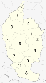
The province is divided into 13 districts (amphoes). The districts are further divided into 133 subdistricts (tambons) and 1,804 villages (mubans).
Local government
As of 26 November 2019 there are[4]: one Maha Sarakham Provincial Administration Organisation (ongkan borihan suan changwat) and 19 municipal (thesaban) areas in the province. Maha Sarakham has town (thesaban mueang) status. Further 18 subdistrict municipalities (thesaban tambon). The non-municipal areas are administered by 123 Subdistrict Administrative Organisations - SAO (ongkan borihan suan tambon).[2]
Human achievement index 2017
| Health | Education | Employment | Income |
| 12 | 40 | 45 | 62 |
| Housing | Family | Transport | Participation |
 |
 |
||
| 26 | 29 | 60 | 21 |
| Province Maha Sarakham, with an HAI 2017 value of 0.5937 is "average", occupies place 33 in the ranking. | |||
Since 2003, United Nations Development Programme (UNDP) in Thailand has tracked progress on human development at sub-national level using the Human achievement index (HAI), a composite index covering all the eight key areas of human development. National Economic and Social Development Board (NESDB) has taken over this task since 2017.[3]
| Rank | Classification |
| 1 - 15 | "high" |
| 16 - 30 | "somewhat high" |
| 31 - 45 | "average" |
| 45 - 60 | "somewhat low" |
| 61 - 77 | "low" |
| Map with provinces and HAI 2017 rankings |
 |
Notes
Reports (data) from Thai government are "not copyrightable" (Public Domain), Copyright Act 2537 (1994), section 7.
References
- Advancing Human Development through the ASEAN Community, Thailand Human Development Report 2014, table 0:Basic Data (PDF) (Report). United Nations Development Programme (UNDP) Thailand. pp. 134–135. ISBN 978-974-680-368-7. Retrieved 17 January 2016, Data has been supplied by Land Development Department, Ministry of Agriculture and Cooperatives, at Wayback Machine.
- "รายงานสถิติจำนวนประชากรและบ้านประจำปี พ.ศ.2561" [Statistics, population and house statistics for the year 2018]. Registration Office Department of the Interior, Ministry of the Interior (in Thai). 31 December 2018. Retrieved 20 June 2019.
- Human achievement index 2017 by National Economic and Social Development Board (NESDB), pages 1-40, maps 1-9, retrieved 14 September 2019, ISBN 978-974-9769-33-1
- "Number of local government organizations by province". dla.go.th. Department of Local Administration (DLA). 26 November 2019. Retrieved 10 December 2019.
42 Maha Sarakham: 1 PAO, 1 Town mun., 18 Subdistrict mun., 123 SAO.
External links
- About Maha Sarakham, Tourism Authority of Thailand (TAT)
- Provincial website (Thai only)
- Maha Sarakham provincial map, coat of arms and postal stamp
- Photos of Maha Sarakham, 1963
Places adjacent to Maha Sarakham Province | ||||||||||
|---|---|---|---|---|---|---|---|---|---|---|
| ||||||||||