Chiang Rai Province
Chiang Rai (Thai: เชียงราย, pronounced [t͡ɕʰīa̯ŋ.rāːj]; Northern Thai: ᨩ᩠ᨿᨦᩁᩣ᩠ᨿ, pronounced [tɕiaŋ.haːj]) is one of Thailand's seventy-six provinces, which lies in upper northern Thailand and is Thailand's northernmost province. It is bordered by the Shan State of Myanmar to the north, Bokeo Province of Laos to the east, Phayao to the south, Lampang to the southwest, and Chiang Mai to the west.
Chiang Rai | |
|---|---|
| เชียงราย | |
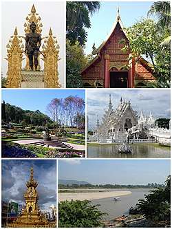 Clockwise from top: King Mangrai Monument, Wat Phra Kaew of Chiang Rai, Wat Rong Khun, Golden Triangle Border in Chiang Saen, Chiang Rai City Clocktower, Doi Tung Royal Villa | |
 Flag  Seal | |
| Motto(s): "เหนือสุดในสยาม ชายแดนสามแผ่นดิน ถิ่นวัฒนธรรมล้านนา ล้ำค่าพระธาตุดอยตุง" ("Northernmost of Siam, border of the three nations, home of Lan Na culture and the precious Wat Phra That Doi Tung") | |
 | |
| Coordinates: 19°54′N 99°49′E | |
| Capital | Chiang Rai |
| Government | |
| • Governor | Prajon Prachsakul (since July 2018) |
| Area | |
| • Total | 11,678 km2 (4,509 sq mi) |
| Area rank | Ranked 12th |
| Population (2018)[2] | |
| • Total | 1,292,130 |
| • Rank | Ranked 15th |
| • Density | 111/km2 (290/sq mi) |
| • Density rank | Ranked 47th |
| Human Achievement Index | |
| • HAI (2017) | 0.6174 "somewhat high" Ranked 20th |
| Time zone | UTC+7 (ICT) |
| Postal code | 57xxx |
| Calling code | 052 & 053 |
| ISO 3166 code | TH-57 |
| Vehicle registration | เชียงราย |
| Accession into Kingdom of Siam | 1910 |
| Accession into Kingdom of Thailand | 1932 |
| Website | www |
Geography
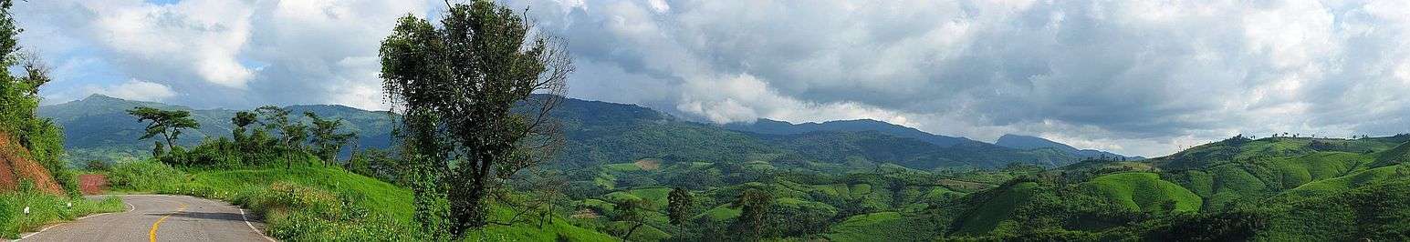
The average elevation of the province is 580 metres (1,903 ft). The north of the province is part of the so-called Golden Triangle, where the borders of Thailand, Laos and Burma converge, an area which prior to the rise of agricultural production of coffee, pineapple, coconuts, and banana plantations, was unsafe because of drug smuggling across the borders. The Mekong River forms the boundary with Laos, the Mae Sai and Ruak River with Burma. Through the town of Chiang Rai itself, flows the "Mae Kok" Kok River and south of it the Lao River, a tributary of the Kok.
While the eastern part of the province is characterized by relatively flat river plains, the northern and western part consist of the hilly terrain of the Thai highlands with the Khun Tan Range and the Phi Pan Nam Range in the west and the Daen Lao Range in the north. While not the highest elevation of the province, the 1,389-metre (4,557 ft) high[4] Doi Tung (Flag Hill) is the most important terrain feature. Wat Phra That Doi Chom Thong wat on top of the hill, according to the chronicles, dates back to the year 911. Nearby is Doi Tung Royal Villa, former residence of the late princess mother (mother of the present king) Somdej Phra Srinagarindra. Thanks to her activities the hills were reforested, and the hill tribes diverted from growing opium poppies to other crops including coffee, bananas, coconuts, and pineapples.
History
Populations have dwelled in Chiang Rai since the 7th century and it became the center of the Lanna Kingdom during the 13th century. The region, rich in natural resources, was occupied by the Burmese until 1786.
Chiang Rai Province's golden triangle bordering Laos and Burma was once the hub of opium production.
Chiang Rai became a province in 1910, after being part of the Lanna Kingdom for centuries. After Lanna was incorporated into Thailand, it remained an autonomous region and thus the Chiang Rai area was administered from Chiang Mai.
Chiang Rai Province is a transit point for Rohingya refugees from Myanmar (Burma) who are transported there from Sangkhlaburi district in Kanchanaburi Province.[5]
Demographics
The majority of the population are ethnic Thai who speak Kham Muang among themselves, but 12.5% are of hill tribes origin, a sizeable minority in the north provinces. A smaller number are of Chinese descent, mainly descendants of the Kuomintang soldiers who settled in the region, notably in Santikhiri.
Ethnic groups
Khon Muang are the city folk who originally came from Chiang Mai, Lamphun, Lampang, and Phrae. Culturally, they design their houses having only one floor with wooden gable decorations called "ka-lae". They are known for their craftsmanship in wood carving, weaving, lacquer ware, and musical instruments.
Tai Yai (Shan) are a Tai ethnic group who primarily live in what is now Shan State in Burma, and also in Mae Hong Son Province in Thailand. They grow rice, farm, raise cattle, and trade. Their craftsmanship lies in weaving, pottery, wood carving, and bronze ware.
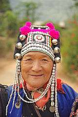
Akha have the largest population of any hill tribe in the region. Originating from Tibet and southern China, they dwell on high ground around 1,200 meters above sea level. Within their villages they build spirit gateways to protect them from evil spirits.
Lahu (Musor) are also from the Yunnanese area and live in high areas. They are known as hunters and planters. Karen live in various areas of the region which have valleys and riverbanks.
Chin Haw in Chiang Rai consist primarily of the former Kuomintang (KMT army) who took refuge in the area, mainly in Santikhiri (formerly Mae Salong).
Hmong from southern China, inhabit high ground. They raise livestock and grow rice, corn, tobacco, and cabbage. They are also known for their embroidery and silver.
Tai Lue (Dai) live in dwellings of usually only a single room wooden house built on high poles. They are skilled in weaving.
Lisu from southern China and Tibet are renowned for their colorful dress and also build their dwellings on high stilts. They harvest rice and corn and their men are skilled in hunting.
Yao (Mien) reside along mountain sides and grow corn and other crops. They are skilled blacksmiths, silversmiths, and embroiders.
Symbols


The seal of the province shows a white elephant, the royal symbol, recalling that Chiang Rai was founded by King Mengrai, according to legend because his elephant liked the place.
The provincial tree is the tree jasmine (Radermachera ignea), and the provincial flower is the orange trumpet (Pyrostegia venusta).
The former provincial slogan was "เหนือสุดในสยาม อร่ามดอยตุง ผดุงวัฒนธรรม รสล้ำข้าวสาร หอมหวานลิ้นจี่ สตรีโสภา ชาเลิศรส สัปปะรดนางแล", 'Northernmost of Siam, beautiful Doi Tung, repository of culture, most delicious rice, sweet and fragrant lychee, beautiful women, the finest flavoured tea, pineapple from Nang Lae, source of the giant catfish".
The current slogan is "เหนือสุดในสยาม ชายแดนสามแผ่นดิน ถิ่นวัฒนธรรมล้านนา ล้ำค่าพระธาตุดอยตุง", 'Northernmost of Siam, frontier of three lands, the home of Lan Na culture and Doi Tung Temple'.
Hospitals
- Kasemrad Sriburin General Hospital, Private hospital.
- Chiangrai Prachanukroh Hospital, Public hospital.
Transport

Air
Chiang Rai International Airport has domestic flights to both Bangkok airports, which connect to regional and international flights.
Boat
There is daily boat service between Chiang Rai and Tha Ton.
Rail
There is no railway system in Chiang Rai. The nearest station is Chiang Mai Railway Station.
Road
Chiang Rai Province is intersected by Asian Highway 2, which runs for over 13,000 kilometres (8,078 mi) from Denpasar in Indonesia to Kosravi in Iran, and by Asian Highway 3, which runs for over 7,000 km (4,350 mi) from Kentung in Myanmar to Ulan-Ude in Russia.
Decent bus services are available in the province. In more remote areas, songthaews are the norm.
Administrative divisions

Provincial government
Chiang Rai is divided into 18 districts (amphoes). The districts are further divided into 124 subdistricts (tambons) and 1,751 villages (mubans).
|
|
Local government
As of 26 November 2019 there are:[6] one Chiang Rai Provincial Administration Organisation (ongkan borihan suan changwat) and 73 municipal (thesaban) areas in the province. Chiang Rai has city (thesaban nakhon) status. Further 72 subdistrict municipalities (thesaban tambon). The non-municipal areas are administered by 70 Subdistrict Administrative Organisations - SAO (ongkan borihan suan tambon).[2]
Human achievement index 2017
| Health | Education | Employment | Income |
| 47 | 41 | 6 | 32 |
| Housing | Family | Transport | Participation |
 |
 |
||
| 29 | 40 | 48 | 13 |
| Province Chiang Rai, with an HAI 2017 value of 0.6174 is "somewhat high", occupies place 20 in the ranking. | |||
Since 2003, United Nations Development Programme (UNDP) in Thailand has tracked progress on human development at sub-national level using the Human achievement index (HAI), a composite index covering all the eight key areas of human development. National Economic and Social Development Board (NESDB) has taken over this task since 2017.[3]
| Rank | Classification |
| 1 - 15 | "high" |
| 16 - 30 | "somewhat high" |
| 31 - 45 | "average" |
| 45 - 60 | "somewhat low" |
| 61 - 77 | "low" |
| Map with provinces and HAI 2017 rankings |
 |
Gallery

 Pu Kaeng Waterfall, Doi Luang National Park
 Huai Mak Liam Hot Spring, Lam Nam Kok National Park
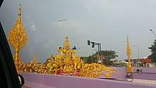 A road tunnel decorated with Thai style art
Notes
Reports (data) from Thai government are "not copyrightable" (Public Domain), Copyright Act 2537 (1994), section 7.
References
- Advancing Human Development through the ASEAN Community, Thailand Human Development Report 2014, table 0:Basic Data (PDF) (Report). United Nations Development Programme (UNDP) Thailand. pp. 134–135. ISBN 978-974-680-368-7. Retrieved 17 January 2016, Data has been supplied by Land Development Department, Ministry of Agriculture and Cooperatives, at Wayback Machine.
- "รายงานสถิติจำนวนประชากรและบ้านประจำปี พ.ศ.2561" [Statistics, population and house statistics for the year 2018]. Registration Office Department of the Interior, Ministry of the Interior (in Thai). 31 December 2018. Retrieved 20 June 2019.
- Human achievement index 2017 by National Economic and Social Development Board (NESDB), pages 1-40, maps 1-9, retrieved 14 September 2019, ISBN 978-974-9769-33-1
- Geographical data
- "Putrajaya's migrant deluge woes", The Star, Kuala Lumpur, Malaysia, 13 May 2015, http://www.thestar.com.my/News/Nation/2015/05/13/Putrajayas-migrant-deluge-woes-Emergency-meetings-held-to-find-solutions/
- "Number of local government organizations by province". dla.go.th. Department of Local Administration (DLA). 26 November 2019. Retrieved 10 December 2019.
12 Chiang Rai: 1 PAO, 1 City mun., 72 Subdistrict mun., 70 SAO.
External links

- Provincial Website(Thai)
- Chiang Rai page from the Tourist Authority of Thailand
- English News Chiang Rai Province
Places adjacent to Chiang Rai Province | ||||||||||
|---|---|---|---|---|---|---|---|---|---|---|
| ||||||||||
Chiang Rai | ||
|---|---|---|
| Main article | | |
| Capital city | ||
| Districts (amphoe) |
| |
| Related topics |
| |
| Authority control |
|
|---|