Amnat Charoen Province
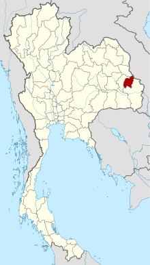
Amnat Charoen (Thai: อำนาจเจริญ, pronounced [ʔām.nâːt t͡ɕā.rɤ̄ːn]) is one of Thailand's seventy-seven provinces (changwat) lies in central northeastern Thailand also called Isan. Neighbouring provinces are (clockwise from the south) Ubon Ratchathani, Yasothon, and Mukdahan. To the east it borders Salavan of Laos. Its name is a concatenation of อำนาจ ("authority, power") and เจริญ ("prosperous").[5]
Amnat Charoen อำนาจเจริญ | |
|---|---|
 Phra Mongkol Ming Muang | |
 Flag  Seal | |
| Motto(s): "พระมงคลมิ่งเมือง แหล่งรุ่งเรืองเจ็ดลุ่มน้ำ งามล้ำถ้ำศักดิ์สิทธิ์ เทพนิมิตพระเหลา เกาะแก่งเขาแสนสวย เลอค่าด้วยผ้าไหม ราษฎร์เลื่อมใสใฝ่ธรรม" ("Phra Mongkhon Mingmueang, Seven Watershed Reservoir, Exceptionally beautiful, sacred caves, God vision of Buddha amulet, Island rapids & beautiful mountain, Precious with silk and People believe in justice.") | |
 Map of Thailand highlighting Amnat Charoen Province | |
| Country | Thailand |
| Capital | Amnat Charoen |
| Government | |
| • Governor | Suthee Thongyam (since October 2019)[1] |
| Area | |
| • Total | 3,161 km2 (1,220 sq mi) |
| Area rank | Ranked 60th |
| Population (2018)[3] | |
| • Total | 378,621 |
| • Rank | Ranked 65th |
| • Density | 120/km2 (300/sq mi) |
| • Density rank | Ranked 42nd |
| Human Achievement Index | |
| • HAI (2017) | 0.5905 "average" Ranked 34th |
| Time zone | UTC+7 (ICT) |
| Postal code | 37xxx |
| Calling code | 045 |
| ISO 3166 code | TH-37 |
| Website | www |
Geography
The province is in the Mekong valley. In dry season, from February to May, water in Mekong River declines, and allows islands to appear. Islands include Kaeng Tanglang at Si Sombun Village, close to Amphoe Chanuman, and Kaeng Hin Khan at Ban Hin Khan, 30 kilometres south of Amphoe Chanuman. The other two rivers in the province are the Lam Sae Bok and Lam Sae Bai.
Phu Sa Dok Bua National Park occupies part of Amnat Charoen Province.
History
Amnat Charoen gained city status during the reign of King Rama III. It was first administered from Nakhon Khemarat, and later from Ubon Ratchathani. It became a province in its own right on 12 January 1993, when it was split off from Ubon Ratchathani. It is thus one of the four newest provinces of Thailand, together with Nong Bua Lam Phu and Sa Kaeo, both also established in 1993, and Bueng Kan, established in 2011.
Economy
The province is overwhelmingly agricultural. In 2008, Amnat Charoen locals developed the so-called "Dhamma agriculture" model based on self-governance and aimed at making the province a hub for organic farming. According to the Office of Agriculture Economics, Amnat Charoen in 2016 had a total of 883,499 rai planted in hom mali rice. Sugarcane plantations increased from 40,688 rai in 2015 to 51,446 rai in 2016.[6]
Symbols
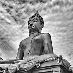
In the middle of the provincial seal is an image of the Buddha called Phra Mongkol Ming Muang. Also known as Phra Yai (Big Buddha), this 20 m high statue is among the most sacred in the city of Amnat Charoen.[5]
The provincial tree is Hopea ferrea.
The provincial slogan is Phra Mongkhon, seven river basins, sacred caves, Phra Lao, beautiful islands and mountain, precious silk and religious people.
Administrative divisions

Provincial government
The province is divided into seven districts (amphoe). The districts are further divided into 56 subdistricts (tambon) and 653 villages (muban).
|
|
Local government
As of 26 November 2019 there are:[7] one Amnat Charoen Provincial Administration Organisation (ongkan borihan suan changwat) and 24 municipal (thesaban) areas in the province. Amnat Charoen has town (thesaban mueang) status. Further 23 subdistrict municipalities (thesaban tambon).The non-municipal areas are administered by 39 Subdistrict Administrative Organisations - SAO (ongkan borihan suan tambon).[3]
Human achievement index 2017
| Health | Education | Employment | Income |
| 44 | 69 | 10 | 73 |
| Housing | Family | Transport | Participation |
 |
 |
||
| 3 | 9 | 72 | 7 |
| Province Amnat Charoen, with an HAI 2017 value of 0.5905 is "average", occupies place 34 in the ranking. | |||
Since 2003, United Nations Development Programme (UNDP) in Thailand has tracked progress on human development at sub-national level using the Human achievement index (HAI), a composite index covering all the eight key areas of human development. National Economic and Social Development Board (NESDB) has taken over this task since 2017.[4]
| Rank | Classification |
| 1 - 15 | "high" |
| 16 - 30 | "somewhat high" |
| 31 - 45 | "average" |
| 45 - 60 | "somewhat low" |
| 61 - 77 | "low" |
| Map with provinces and HAI 2017 rankings |
 |
Notes
Reports (data) from Thai government are "not copyrightable" (Public Domain), Copyright Act 2537 (1994), section 7.
References
- "ประกาศสำนักนายกรัฐมนตรี เรื่อง แต่งตั้งข้าราชการพลเรือนสามัญ" [Announcement of the Prime Minister's Office regarding the appointment of civil servants] (PDF). Royal Thai Government Gazette. 136 (Special 242 Ngor). 30. 28 September 2019. Retrieved 24 November 2019.
- Advancing Human Development through the ASEAN Community, Thailand Human Development Report 2014, table 0:Basic Data (PDF) (Report). United Nations Development Programme (UNDP) Thailand. pp. 134–135. ISBN 978-974-680-368-7. Retrieved 17 January 2016, Data has been supplied by Land Development Department, Ministry of Agriculture and Cooperatives, at Wayback Machine.
- "รายงานสถิติจำนวนประชากรและบ้านประจำปี พ.ศ.2561" [Statistics, population and house statistics for the year 2018]. Registration Office Department of the Interior, Ministry of the Interior (in Thai). 31 December 2018. Retrieved 20 June 2019.
- Human achievement index 2017 by National Economic and Social Development Board (NESDB), pages 1-40, maps 1-9, retrieved 14 September 2019, ISBN 978-974-9769-33-1
- "Amnat Charoen". Thailex Travel Encyclopedia. Retrieved 29 January 2016.
- Kotamee, Itthiphon; Pratthanawutthikun, Pitak (17 November 2017). "Sugarcane is stealing the thunder of the organic rice movement in Amnat Charoen". Isaan Record. Retrieved 19 November 2017.
- "Number of local government organizations by province". dla.go.th. Department of Local Administration (DLA). 26 November 2019. Retrieved 10 December 2019.
76 Amnat Charoen: 1 PAO, 1 Town mun., 23 Subdistrict mun., 39 SAO.
External links
Places adjacent to Amnat Charoen Province | ||||||||||
|---|---|---|---|---|---|---|---|---|---|---|
| ||||||||||
See also
- Khit cloth
External links

- Province page from the Tourist Authority of Thailand
- Website of the province (Thai only)
Places adjacent to Amnat Charoen Province | ||||||||||
|---|---|---|---|---|---|---|---|---|---|---|
| ||||||||||