Huai Krachao District
Huai Krachao (Thai: ห้วยกระเจา, pronounced [hûa̯j krā.t͡ɕāw]) is a district (amphoe) in the eastern part of Kanchanaburi Province, central Thailand.
Huai Krachao ห้วยกระเจา | |
|---|---|
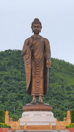 Phra Phutta Maha Metta, the tallest staue in the province | |
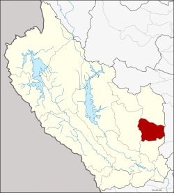 District location in Kanchanaburi Province | |
| Coordinates: 14°19′38″N 99°40′0″E | |
| Country | Thailand |
| Province | Kanchanaburi |
| Seat | Huai Krachao |
| Area | |
| • Total | 622.0 km2 (240.2 sq mi) |
| Population (2005) | |
| • Total | 32,602 |
| • Density | 52.5/km2 (136/sq mi) |
| Time zone | UTC+7 (ICT) |
| Postal code | 71170 |
| Geocode | 7113 |
History
Tambons Huai Krachao, Wang Phai, Sa Long Ruea, and Don Salaep were separated from Phanom Thuan District and formed the minor district (king amphoe) Huai Krachao on 30 April 1994.[1] It was upgraded to district status on 11 October 1997.[2]
Geography
Neighboring districts are (from the south clockwise) Phanom Thuan, Bo Phloi, Lao Khwan of Kanchanaburi Province and U Thong of Suphanburi Province.
Administration
The district is divided into four sub-districts (tambons), which are further subdivided into 67 villages (mubans). There are no municipal (thesaban) areas. There are four tambon administrative organizations (TAO).
| No. | Name | Thai name | Villages | Pop. | |
|---|---|---|---|---|---|
| 1. | Huai Krachao | ห้วยกระเจา | 20 | 8,927 | |
| 2. | Wang Phai | วังไผ่ | 11 | 4,347 | |
| 3. | Don Salaep | ดอนแสลบ | 22 | 12,119 | |
| 4. | Sa Long Ruea | สระลงเรือ | 14 | 7,209 |
References
- ประกาศกระทรวงมหาดไทย เรื่อง แบ่งเขตท้องที่อำเภอพนมทวน จังหวัดกาญจนบุรี ตั้งเป็นกิ่งอำเภอห้วยกระเจา (PDF). Royal Gazette (in Thai). 111 (42 ง): 12. May 26, 1994.
- พระราชกฤษฎีกาตั้งอำเภอหนองปรือ อำเภอห้วยกระเจา อำเภอทรายทองวัฒนา อำเภอปางศิลาทอง อำเภอเนินสง่า อำเภอนาทม อำเภอพระพรหม อำเภอแม่วงก์ อำเภอสองแคว อำเภอบ้านใหม่ไชยพจน์ อำเภอไทยเจริญ อำเภอกาบัง อำเภอพยุห์ อำเภอเมืองจันทร์ อำเภอภูพาน อำเภอคลองหอยโข่ง อำเภอเขาฉกรรจ์ อำเภอนาวัง อำเภอพิบูลย์รักษ์ และอำเภอทุ่งศรีอุดม พ.ศ. ๒๕๔๐ (PDF). Royal Gazette (in Thai). 114 (50 ก): 24–27. September 26, 1997.
External links
|  | |
This article is issued from Wikipedia. The text is licensed under Creative Commons - Attribution - Sharealike. Additional terms may apply for the media files.