Tak Province
Tak (Thai: ตาก, pronounced [tàːk]) is one of Thailand's seventy-six provinces (changwat) lies in lower northern Thailand. Neighbouring provinces are (from north clockwise) Mae Hong Son, Chiang Mai, Lamphun, Lampang, Sukhothai, Kamphaeng Phet, Nakhon Sawan, Uthai Thani and Kanchanaburi. The western edge of the province has a long boundary with Kayin State of Myanmar (Burma).
Tak ตาก | |
|---|---|
 Ping River | |
 Flag 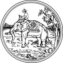 Seal | |
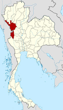 Map of Thailand highlighting Tak Province | |
| Country | Thailand |
| Region | Lower northern |
| Capital | Tak |
| Largest City | Mae Sot |
| Government | |
| • Governor | Orassit Samphantharat (since October 2019)[1] |
| Area | |
| • Total | 16,407 km2 (6,335 sq mi) |
| Area rank | Ranked 4th |
| Population (2018)[3] | |
| • Total | 654,676 |
| • Rank | Ranked 39th |
| • Density | 40/km2 (100/sq mi) |
| • Density rank | Ranked 76th |
| Human Achievement Index | |
| • HAI (2017) | 0.5631 "low" Ranked 61st |
| Time zone | UTC+7 (ICT) |
| Postal code | 63xxx |
| Calling code | 055 |
| ISO 3166 code | TH-63 |
| Website | www |
Geography
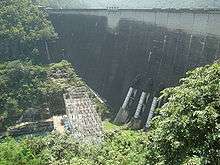
The Bhumibol Dam (named after King Bhumibol Adulyadej, the old name was Yanhee Dam) is in Khao Kaew Tambon (sub-district), Sam Ngao District of Tak and was built from 1958 to 1964.[5] It stops the river Ping, one of the two sources of the Chao Phraya River.[6][7][8] The artificial lake created covers an area of 300 km² and is the largest in Thailand. Taksin Maharat National Park, Namtok Pha Charoen National Park, Lan Sang National Park, and Khun Phawo National Parks are all in the province. Thungyai Naresuan Wildlife Sanctuary shares half of the lake front with Kanchanaburi and Huai Kha Khaeng Wildlife Sanctuary at the border with Uthai Thani and are World Heritage Sites.[9][10]
On the western side of Tak Province the Tenasserim Hills meet the Dawna Range. One of the few transnational roads and cross-border points into Myanmar is at Mae Sot. Northwest of Mae Sot the main road on the Thai side skirts the border until it turns straight north towards Mae Hong Son.
Tak Province occupies 16,406 km2 and lies 426 km north of Bangkok.[11]
History
Tak was a historical kingdom built over 2,000 years ago, even before the Sukhothai period. The ancient kingdom had its peak around the 1st century. By the 5th century the capital of this kingdom was moved south to Lavo (present day Lopburi Province). A city named Ban Tak was established by Jamadevi (พระนางจามเทวี), princess of the Lavo kingdom, around 663 CE. It became part of the Sukhothai kingdom through battles led by Ramkhamhaeng the Great and formed the main fortress on the western front. The city was moved further west and renamed Mueang Rahang when the Ayuthaya kingdom was lost to Burma during King Maha Thammaracha's reign. The city was moved back to the east side of the Ping River during the early Bangkok period.[12]
King Taksin was vice-governor of Tak before the Ayutthaya kingdom fell during the war with Burma. As his name was Sin, he became called Tak-Sin during his time in Tak.[13]
Demographics
About a quarter of the population belongs to one of Thailand's hill tribes: Yao, Karen (Thai Kariang), Akha (Thai Akha), Lahu (Thai Musoe), Hmong (Thai Mong), and Lisu (Thai Lisaw).[14] The largest tribe in Tak is Karen.[15]
Refugees
According to the UNHCR data of 2008, nearly 95,000 of Thailand's 121,000 registered refugees from Burma are housed in several refugee camps in Tak province of which Mae La camp is the largest with around 45,000 Karen refugees.[16]
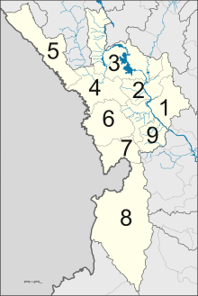
Administrative divisions
Provincial government
The province is divided into nine districts (amphoes). These are further divided into 63 subdistricts (tambons) and 493 villages (mubans).
Local government
As of 26 November 2019 there are[17]: one Tak Provincial Administration Organisation (ongkan borihan suan changwat) and 19 municipal (thesaban) areas in the province. Mae Sot has city (thesaban nakhon) status. Tak has town (thesaban mueang) status. Further 17 subdistrict municipalities (thesaban tambon). The non-municipal areas are administered by 49 Subdistrict Administrative Organisations - SAO (ongkan borihan suan tambon).[3]
Symbols
The provincial seal shows King Naresuan on the royal elephant.[11] Sometimes below the elephant a garuda is depicted, as the garuda is the state symbol of Thailand. King Naresuan is shown pouring consecrated water on the ground, a symbolic act to declare independence. This refers to the war of 1584 with Burma, when Tak was the first border town to be liberated from Burmese control.
The provincial slogan is, "A town of wonderful nature, huge Bhumiphol Dam, King Taksin The Great and beautiful forests".[11]
The provincial tree is the Asian Jatoba (Xylia kerrii), the provincial flower is the Orchid tree (Bauhinia sp.).
Economy
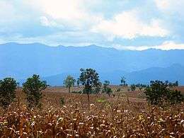
Agriculture is a major part of the Tak economy. The province of Tak produces rice, corn, vegetables, fruits, beef, tilapia, and other foods. Industries in Tak include granite quarrying and jewelry. Zinc mining was formerly conducted in Mae Sot District.[18]
Handicrafts and Myanmar products are also important for trade. The Bhumibol Dam in the northern part of Tak is its most popular tourist attraction. Tourism, especially ecotourism, in the southern part is seasonal with popular destinations such as the Thi Lo Su Waterfall, Thi Lo Le Waterfall, hiking and white water rafting in its various forest reserves. Tak is also known for its Loi Krathong festival where krathong sai (กระทงสาย) consisting of many krathongs are floated in a long line down the river.[19] The Loi Krathong festival is held on the Ping River in Mueang Tak District on Loi Krathong night.
Transportation
Roads
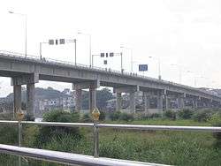
Tak is a key communication and transportation centre of the north, with three Asian highways passing through the province. AH1 enters through the Myanmar-Thai border at Mae Sot District[20] AH2 passes through the province from north to south. Also AH16 terminates at Tak.
Air
Tak Province is served by Tak Airport.
Human achievement index 2017
| Health | Education | Employment | Income |
| 7 | 73 | 17 | 66 |
| Housing | Family | Transport | Participation |
 |
 |
||
| 51 | 17 | 67 | 42 |
| Province Tak, with an HAI 2017 value of 0.5631 is "low", occupies place 61 in the ranking. | |||
Since 2003, United Nations Development Programme (UNDP) in Thailand has tracked progress on human development at sub-national level using the Human achievement index (HAI), a composite index covering all the eight key areas of human development. National Economic and Social Development Board (NESDB) has taken over this task since 2017.[4]
| Rank | Classification |
| 1 - 15 | "high" |
| 16 - 30 | "somewhat high" |
| 31 - 45 | "average" |
| 45 - 60 | "somewhat low" |
| 61 - 77 | "low" |
| Map with provinces and HAI 2017 rankings |
 |
Notes
Reports (data) from Thai government are "not copyrightable" (Public Domain), Copyright Act 2537 (1994), section 7.
References
- "ประกาศสำนักนายกรัฐมนตรี เรื่อง แต่งตั้งข้าราชการพลเรือนสามัญ" [Announcement of the Prime Minister's Office regarding the appointment of civil servants] (PDF). Royal Thai Government Gazette. 136 (Special 242 Ngor). 9. 28 September 2019. Retrieved 24 November 2019.
- Advancing Human Development through the ASEAN Community, Thailand Human Development Report 2014, table 0:Basic Data (PDF) (Report). United Nations Development Programme (UNDP) Thailand. pp. 134–135. ISBN 978-974-680-368-7. Retrieved 17 January 2016, Data has been supplied by Land Development Department, Ministry of Agriculture and Cooperatives, at Wayback Machine.
- "รายงานสถิติจำนวนประชากรและบ้านประจำปี พ.ศ.2561" [Statistics, population and house statistics for the year 2018]. Registration Office Department of the Interior, Ministry of the Interior (in Thai). 31 December 2018. Retrieved 20 June 2019.
- Human achievement index 2017 by National Economic and Social Development Board (NESDB), pages 1-40, maps 1-9, retrieved 14 September 2019, ISBN 978-974-9769-33-1
- "Bhumibol Dam". Rid Go Th. Archived from the original on 17 September 2008. Retrieved 2008-07-20.
- "Royal Irrigation Department River Gauges Report". RID Stations. 2002. Archived from the original on 14 August 2009. Retrieved 2008-07-20.
- "Chao Phraya River Basin (Thailand)". World Water Assessment Programme. Archived from the original on 8 June 2008. Retrieved 2008-07-20.
- "Detailed Map of the Chao Phraya River Basin (Thailand)". World Water Assessment Programme. Archived from the original on 18 September 2008. Retrieved 2008-07-20.
- "Thung Yai Naresuan Wildlife Sanctuary". United Nations Environment Programme - World Conservation Monitoring Centre. March 1991. Archived from the original on 2008-07-18. Retrieved 2008-07-21.
- "Huai Kha Khaeng Wildlife Sanctuary". United Nations Environment Programme - World Conservation Monitoring Centre. March 1991. Archived from the original on 2008-07-18. Retrieved 2008-07-21.
- "General Data". Tak Province. Retrieved 18 May 2015.
- "General Information - Tak". North of Thailand. Archived from the original on 12 June 2015. Retrieved 2008-07-21.
- "King Taksin the Great". Wangderm Palace. 2003. Archived from the original on 2002-08-10. Retrieved 2008-08-02.
- "Travel Thailand: The Twilight That Tak Province". Thailand Live. Archived from the original on 2012-11-29. Retrieved 2008-08-04.
- "Mountain-Biking and Trekking in Northwest Thailand". Thai Cycling. Archived from the original on 30 March 2009. Retrieved 2008-08-04.
- "Myanmar Thailand Border: Refugee Population By Gender". The UN Refugee Agency. 2008-04-01. Retrieved 2017-11-16.
- "Number of local government organizations by province". dla.go.th. Department of Local Administration (DLA). 26 November 2019. Retrieved 10 December 2019.
16 Tak: 1 PAO, 1 City mun., 1 Town mun., 17 Subdistrict mun., 49 SAO.
- Wipatayotin, Apinya (14 November 2018). "Cadmium-sickened villagers awarded B16m compensation". Bangkok Post. Retrieved 14 November 2018.
- "Loy Krathong Sai". Tourism Authority of Thailand (TAT). Retrieved 18 May 2015.
- "Mae Sot Thailand". Thaipro. Retrieved 2008-07-31.;
External links

| Wikimedia Commons has media related to Tak Province. |
Places adjacent to Tak Province | |
|---|---|