Lampang Province
Lampang (Thai: ลำปาง, pronounced [lām.pāːŋ]) is one of Thailand's seventy-six provinces (changwat), lies in upper northern Thailand. The old name of Lampang was Khelang Nakhon.
Lampang ลำปาง | |
|---|---|
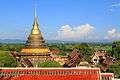
.jpg) Wat Phra That Lampang Luang | |
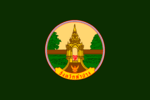 Flag  Seal | |
| Nickname(s): Khelang Nakhon Kukuta Nakhon (white rooster city) Mueang Rot Ma (horse carriage city) | |
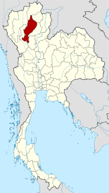 Map of Thailand highlighting Lampang Province | |
| Country | Thailand |
| Capital | Nakhon Lampang |
| Government | |
| • Governor | Narongkhak Osotthanakorn (since October 2019)[1] |
| Area | |
| • Total | 12,534 km2 (4,839 sq mi) |
| Area rank | Ranked 10th |
| Population (2018)[3] | |
| • Total | 742,883 |
| • Rank | Ranked 33rd |
| • Density | 59/km2 (150/sq mi) |
| • Density rank | Ranked 69th |
| Human Achievement Index | |
| • HAI (2017) | 0.6450 "high" Ranked 9th |
| Time zone | UTC+7 (ICT) |
| Postal code | 52xxx |
| Calling code | 054 |
| ISO 3166 code | TH-52 |
| Vehicle registration | ลำปาง |
| Website | www |
Geography
Lampang is in the broad river valley of the Wang River, surrounded by mountains. In Mae Mo District lignite is found and mined in open pits. To the north of the province is the 1,697-metre (5,568 ft) high Doi Luang.
Within the province are Chae Son and Doi Khun Tan National Parks in the Khun Tan Range, as well as Tham Pha Thai, Doi Luang National Park, and the Huai Tak Teak Biosphere Reserve in the Phi Pan Nam Range.[5]
History
Starting in the 7th century Lampang was part of the Dvaravati period Hariphunchai Kingdom of the Mon. In the 11th century the Khmer Empire occupied the Lampang area, but it was King Mengrai of Lanna who incorporated the complete Haripunchai Kingdom into his kingdom in 1292. Lampang or Nakhon Lampang or Lakhon, was under Burmese rule after the fall of Lanna Kingdom from the 16th century to 18th century. During the uprising against Burmese rule by Siam's new kings in the late-18th century, a local Lampang leader became Siam's ally. After the victory, the leader, Kawila, was named the ruler of Chiang Mai, the former center of Lanna, while his relative ruled Lampang. The city continues to be one of the important economic and political centers in the north. Lampang became a province of Thailand in 1892.[6]
Transport
The city is an important highway hub, with a four lane highway link to Chiang Mai and Chiang Rai, as well as a major highway to Phrae and the eastern Lanna provinces. Lampang is roughly a 1.5 hour bus ride to Chiang Mai. Lampang is a stop for the Chiang Mai-bound train, approximately 10 hours from Bangkok.
Lampang Airport is served by Bangkok Airways (three flights daily to Suvarnabhumi Airport) and Nok air (four flights daily to Don Mueang) (Oct 2015).
Health
The main hospital of Lampang is Lampang Hospital, operated by the Ministry of Public Health.
Tourism
Lampang Province is not visited by many tourists, only about 900,000 per year, most of them passing through. In early-2019, the provincial governor rolled out a program called "Lampang: Dream Destination" to raise the number of visitors to two million within two years.[7]
Economy
Lampang is known for the production of ceramic goods and its mining operations. A great deal of ball clay, china stone, and lignite are extracted from the surrounding mountains. There are more than 200 ceramic factories in and around Mueang Lampang District. Most are small- to medium-sized operations producing novelties (plant pots, dolls), tableware, and building materials (tiles, railings). The largest coal fired power plant in Southeast Asia[8] is in Mae Mo District near the lignite mining area. The plant uses lignite as fuel. The largest concrete plant is also north of Mueang Lampang. This is also powered by lignite. Limestone is another abundant rock mined in Lampang. Agriculturally, the province produces rice and pineapples.
Symbols
The provincial seal shows a white rooster inside the entrance to the Phra That Lampang Luang Temple. According to local legend, Buddha visited the province. The god Indra worried that the people would not wake up by themselves to show respect to Buddha, and therefore woke them by transforming himself into a white rooster.
The provincial flower is the Heliconia (Heliconia sp.), and the provincial tree is the Indian Elm (Holoptelea integrifolia). According to the legend, this tree was planted in the temple during Buddha's visit.
Administrative divisions
Provincial government
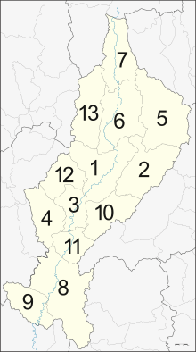
The province is divided into 13 districts (amphoes). These are further divided into 100 subdistricts (tambons) and 855 villages (mubans).
|
Local government
As of 26 November 2019 there are[9]: one Lampang Provincial Administration Organisation (ongkan borihan suan changwat) and 42 municipal (thesaban) areas in the province. Lampang has city (thesaban nakhon) status. Khelang Nakhon, Lom Raet and Phichai have town (thesaban mueang) status. Further 38 subdistrict municipalities (thesaban tambon). The non-municipal areas are administered by 60 Subdistrict Administrative Organisations - SAO (ongkan borihan suan tambon).[3]
Human achievement index 2017
| Health | Education | Employment | Income |
| 69 | 13 | 35 | 48 |
| Housing | Family | Transport | Participation |
 |
 |
||
| 33 | 27 | 22 | 4 |
| Province Lampang, with an HAI 2017 value of 0.6450 is "high", occupies place 9 in the ranking. | |||
Since 2003, United Nations Development Programme (UNDP) in Thailand has tracked progress on human development at sub-national level using the Human achievement index (HAI), a composite index covering all the eight key areas of human development. National Economic and Social Development Board (NESDB) has taken over this task since 2017.[4]
| Rank | Classification |
| 1 - 15 | "high" |
| 16 - 30 | "somewhat high" |
| 31 - 45 | "average" |
| 45 - 60 | "somewhat low" |
| 61 - 77 | "low" |
| Map with provinces and HAI 2017 rankings |
 |
Gallery
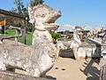 Singha Lanna
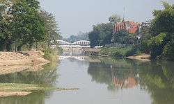 Wang River
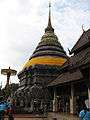 Phra That Lampang Luang
 Burmese-style Wat Srichum
 Hot springs at Chae Son National Park
Notes
Reports (data) from Thai government are "not copyrightable" (Public Domain), Copyright Act 2537 (1994), section 7.
References
- "ประกาศสำนักนายกรัฐมนตรี เรื่อง แต่งตั้งข้าราชการพลเรือนสามัญ" [Announcement of the Prime Minister's Office regarding the appointment of civil servants] (PDF). Royal Thai Government Gazette. 136 (Special 242 Ngor). 20. 28 September 2019. Retrieved 24 November 2019.
- Advancing Human Development through the ASEAN Community, Thailand Human Development Report 2014, table 0:Basic Data (PDF) (Report). United Nations Development Programme (UNDP) Thailand. pp. 134–135. ISBN 978-974-680-368-7. Retrieved 17 January 2016, Data has been supplied by Land Development Department, Ministry of Agriculture and Cooperatives, at Wayback Machine.
- "รายงานสถิติจำนวนประชากรและบ้านประจำปี พ.ศ.2561" [Statistics, population and house statistics for the year 2018]. Registration Office Department of the Interior, Ministry of the Interior (in Thai). 31 December 2018. Retrieved 20 June 2019.
- Human achievement index 2017 by National Economic and Social Development Board (NESDB), pages 1-40, maps 1-9, retrieved 14 September 2019, ISBN 978-974-9769-33-1
- UNESCO - MAB Biosphere Reserves Directory - Huai Tak Teak Biosphere Reserve
- Burmese-influenced Architecture in lampang
- Svasti, Pichaya (24 January 2019). "Northern Star Rising". Bangkok Post. Retrieved 24 January 2019.
- Kongrut, Anchalee (21 October 2015). "Sustaining environmental activism". Bangkok Post. Retrieved 21 October 2015.
- "Number of local government organizations by province". dla.go.th. Department of Local Administration (DLA). 26 November 2019. Retrieved 10 December 2019.
52 Lampang: 1 PAO, 1 City mun., 3 Town mun., 38 Subdistrict mun., 60 SAO.
External links

| Wikimedia Commons has media related to Lampang Province. |
- Province page from the Tourist Authority of Thailand
- Golden Jubilee Network province guide
- Lampang provincial map, coat of arms and postal stamp
Places adjacent to Lampang Province | |
|---|---|