Chiang Mai Province
Chiang Mai (Thai: เชียงใหม่, pronounced [t͡ɕʰīa̯ŋ.màj] (![]()
Chiang Mai | |
|---|---|
| เชียงใหม่ | |
  Doi Inthanon, Wachirathan Falls | |
 Flag  Seal | |
| Motto(s): "ดอยสุเทพเป็นศรี ประเพณีเป็นสง่า บุปผชาติล้วนงามตา นามล้ำค่านครพิงค์" ("Doi Suthep is Sri, Tradition is elegant, Beautiful blossoms and Invaluable name of Nakornping") | |
 | |
| Coordinates: 18°50′14″N 98°58′14″E | |
| Founded by | Mangrai |
| Capital | Chiang Mai |
| Government | |
| • Governor | Charoenrit Sanguansat (since October 2019)[1] |
| Area | |
| • Total | 20,107 km2 (7,763 sq mi) |
| Area rank | Ranked 2nd |
| Population (2018)[2] | |
| • Total | 1,763,742 |
| • Rank | Ranked 5th |
| • Density | 88/km2 (230/sq mi) |
| • Density rank | Ranked 54th |
| Human Achievement Index | |
| • HAI (2017) | 0.6159 "somewhat high" Ranked 21st |
| Time zone | UTC+7 (ICT) |
| Postal code | 50xxx |
| Calling code | 052 & 053 |
| ISO 3166 code | TH-50 |
| Vehicle registration | เชียงใหม่ |
| Accession into Siam (Thailand) | 1910 |
| Website | www |
Geography
Chiang Mai Province is about 685 km (426 mi) from Bangkok in the Mae Ping River basin and is on average at 300 m (1,000 ft) elevation. Surrounded by the mountain ranges of the Thai highlands, it covers an area of approximately 20,107 km2 (8,000 sq mi). The mountains of the Daen Lao Range (ทิวเขาแดนลาว) at the north end of the province, the Thanon Thong Chai Range (เทือกเขาถนนธงชัย) with the highest mountain in Thailand, Doi Inthanon at 2,565 metres (8,415 ft), stretching in a north-south direction, and the Khun Tan Range in the east of the province are covered by rain forest. The Mae Ping, one of the major tributaries of the Chao Phraya River, originates in the Daen Lao mountains. Several national parks are in the province: Doi Inthanon[4], Doi Suthep-Pui,[5] Ob Luang,[6] Sri Lanna,[7] Huai Nam Dang,[8] Mae Wang,[9] and Pha Daeng.[10]
History
Chiang Mai the capital of Chiang Mai Province was capital of the Lanna Kingdom after its founding in 1296, during the same period of time as the establishment of the Sukhothai Kingdom.[11] From then, Chiang Mai not only became the capital and cultural core of the Lanna Kingdom, it was also the centre of Buddhism in northern Thailand and King Meng Rai built innumerable temples.
In 1599, the kingdom lost its independence and became part of the Ayutthaya Kingdom. This ended the dynasty founded by King Meng Rai, an era that last 300 years. The Burmese occupiers, had a powerful Burmese influence on the architecture which can still be seen today. It was only in the late 18th century that Burma was finally defeated with the leadership of King Taksin.
In 1932 the Chiang Mai province moved up to the second level subdivision of Thailand when the administrative unit of Monthon Phayap, the remains of the Lanna Kingdom, was dissolved.
Demographics
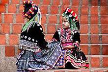
13.4 percent of the population in the province are members of hill tribes:
- Akha the largest population of any hill tribe in the region. Originating from Tibet and Southern China, they dwell on high ground around 1,200 metres (3,937 ft) above sea-level. Within their villages they build a spirit gateway to protect them from evil spirits.
- Hmong from southern China. Prefer higher elevations. They raise livestock and grow rice, corn, tobacco, and cabbage. Known for their embroidery and silver.
- Karen occupy valleys and riverbanks.
- Lahu from southern China and live in high areas. They are known as hunters and planters.
- Lisu from southern China and Tibet are renowned for their colorful dress and also build their dwellings on high poles. They harvest rice and corn and their men are skilled in hunting.
- Tai Lue live in dwellings of usually only a single room wooden house built on high poles. They are skilled in weaving.
- Tai Yai, Burmese in origin, harvest rice, farm, raise cattle and trade. Their craftsmanship lies in weaving, pottery, wood carving and bronze ware.
- Yao reside on mountainsides and grow corn and other crops. They are skilled blacksmiths, silversmiths and embroiders.
- CGM48 is a Thai sister groups of BNK48
Symbols

The seal of the province shows a white elephant in a glass pavilion. The white elephant is a royal symbol in Thailand, and it is depicted to remember the offering of a white elephant by Thammalangka, a ruler of Chiang Mai, to his overlord, King Rama II of Bangkok. The pavilion symbolizes that Buddhism prospered in Chiang Mai, especially when in 1477 the teachings of Buddha, the Tripitaka, were reviewed.[12]
The provincial flower and tree is the "flame of the forest" (Butea monosperma).[12]
The provincial slogan is In the shadow of Mount Doi Suthep, blessed with rice customs and traditions, beautiful wild flowers, magnificent Nakhon Phing.[12]
Administrative divisions and postal codes

Chiang Mai is subdivided into 25 districts (amphoe). The districts are further divided into 204 subdistricts (tambon) and 2,066 villages (muban).
|
|
Local government
As of 26 November 2019 there are[14]: one Chiang Mai Provincial Administration Organisation (ongkan borihan suan changwat) and 121 municipal (thesaban) areas in the province. Chiang Mai has city (thesaban nakhon) status. Mae Jo, Mae Hia, Mueang Kaen Phatthana and Ton Pao have town (thesaban mueang) status. Further 116 subdistrict municipalities (thesaban tambon). The non-municipal areas are administered by 89 Subdistrict Administrative Organisations - SAO (ongkan borihan suan tambon).[2]
Climate
Chiang Mai has a tropical wet and dry climate (Köppen Aw), tempered by the low latitude and moderate elevation, with warm to hot weather year-round, though nighttime conditions during the dry season can be cool and are much lower than daytime highs. The maximum temperature ever recorded is 42.4 °C (108.3 °F) in May 2005.[15]
Human achievement index 2017
| Health | Education | Employment | Income |
| 39 | 10 | 56 | 17 |
| Housing | Family | Transport | Participation |
 |
 |
||
| 39 | 70 | 26 | 11 |
| Province Chiang Mai, with an HAI 2017 value of 0.6159 is "somewhat high", occupies place 21 in the ranking. | |||
Since 2003, United Nations Development Programme (UNDP) in Thailand has tracked progress on human development at sub-national level using the Human achievement index (HAI), a composite index covering all the eight key areas of human development. National Economic and Social Development Board (NESDB) has taken over this task since 2017.[3]
| Rank | Classification |
| 1 - 15 | "high" |
| 16 - 30 | "somewhat high" |
| 31 - 45 | "average" |
| 45 - 60 | "somewhat low" |
| 61 - 77 | "low" |
| Map with provinces and HAI 2017 rankings |
 |
Transportation

- Road: Chiang Mai is on Highway 11, the only 2-digit road number in the province. Other roads connect the city of Chiang Mai with the north and south of the province, as well as with the east towards Chiang Rai province.
- Train: Chiang Mai railway station is the northern terminus of the Northern Line, operated by the State Railway of Thailand.
- Air: Chiang Mai International Airport (CNX) is one of the seven Thai international airports under the aegis of the Airports of Thailand Public Company Limited (AOT).[16] As Chiang Mai International Airport is the major gateway to northern Thailand, it plays an important role in promoting travel and tourism throughout the northern region. Today, 14 airlines serve the airport and more than 3,000,000 passengers, 15,000 flights, and 16,000 tons of cargo are handled annually.*Songthaew
Tourism
Chiang Mai Province is the tourist hub of the north and one of Thailand's most important tourist destinations.It is considered one of the most scenic provinces in the country due to its mountain ranges, valleys, flora, and fauna. For example, the Hang Dong Canyon is coveted as a great tourist attraction. Furthermore, unlike most of Thailand, in some months, the climate in the north and Chiang Mai is cool, fresh, and misty.
Health
Each amphoe of Chiang Mai has its own hospital, but among the largest are located in Mueang Chiang Mai District and include Maharaj Nakorn Chiang Mai Hospital and Nakornping Hospital.
Local products
Chiang Mai is a handicrafts centre, with a variety of antiques, silver jewellery, and embroidery, Thai silks and cottons, basketry, celadon, silverware, furniture, lacquerware, woodcarvings, and parasols.[17]
Local culture
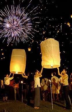
The north of Thailand's culture is Lanna in origin and the people are proud of their northern roots. The region is home to distinctive foods, music, arts, way of life, and even language. Chiang Mai is home to various hill tribes and their own distinctive cultures.
Local Food
- Nam phrik ong is a type of Nam phrik chili paste which is made of minced pork and tomatoes. It is usually eaten with soft-boiled vegetables, pork crackling, or deep-fried crunchy rice cakes.
- Nam phrik num meaning "chili paste young man", is another kind of paste which can be eaten with pork crackling.
- Sai ua is a local sausage that is very aromatic and spicy and is usually eaten with sticky rice.
- Kaeng meaning "curry", is not made with coconut milk in the north.
- Kaeng hang-le is northern-style pork curry
- Kaeng om is a spicy curry consisting of intestines
- Kaeng khae is a spicy curry consisting mainly of vegetables.
- Khanom chin nam ngiao is a traditional northern noodle dish with chicken or pork.
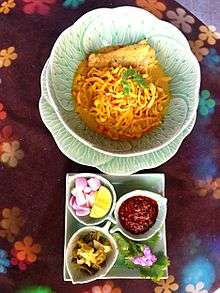
- Khao soi is a noodle dish which can be made from chicken, pork, or beef made with coconut milk and garnished with chopped fresh shallots, pickled cabbage, chilli paste to taste, and a slice of fresh lime.
Sports
There are two main sport stadia in Chiang Mai and its environs: 700th Anniversary Stadium and Province Stadium. 700th Anniversary Stadium is on Klongchonpratan Road, 7 km (4.3 mi) from Chiang Mai University. There are swimming pools, diving pool, basketball arena, and 11 tennis courts.
Sister cities
The province is twinned with eight provinces/states.[18]
Notable inhabitants
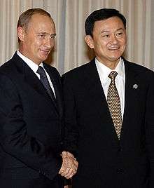
- Thaksin Shinawatra (Thai:ทักษิณ ชินวัตร) (born 1949), politician and businessman
- Yingluck Shinawatra (Thai:ยิ่งลักษณ์ ชินวัตร) (born 1967), politician
Gallery
 The viewpoint at the 41st km of the Highway 1009, Doi Inthanon
 Prunus cerasoides blooming at Doi Suthep–Pui National Park
 Pong Dueat Hot Springs, Huai Nam Dang National Park
 Ob Khan National Park
 Mae Wang National park
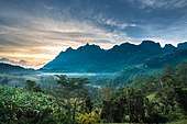
 Doi Chiang Dao mountain
 The mountains of Chiang Dao Wildlife Sanctuary in Chiang Dao District
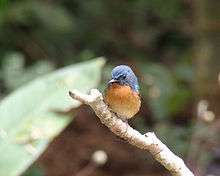 A photo of a hill blue flycatcher in the Chiang Dao Wildlife Sanctuary
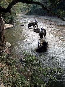 Bathing elephants in the Taeng River
 Mae Thun Noi, Omkoi
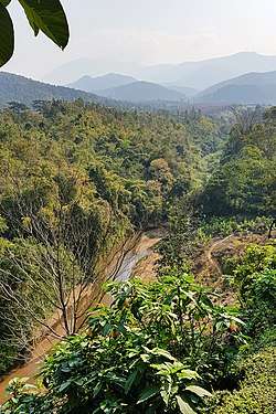 The Fang River, part of the Mekong watershed, in Chai Prakan District
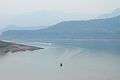 The lake of Mae Ngat Somboon Chon Dam, Si Lanna National Park
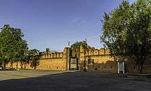 East gate (Tha Phae Gate) of the city wall
 Shopping Mall in Chiang Mai
Notes
Reports (data) from Thai government are "not copyrightable" (Public Domain), Copyright Act 2537 (1994), section 7.
References
- "ประกาศสำนักนายกรัฐมนตรี เรื่อง แต่งตั้งข้าราชการพลเรือนสามัญ" [Announcement of the Prime Minister's Office regarding the appointment of civil servants] (PDF). Royal Thai Government Gazette. 136 (Special 242 Ngor). 7. 28 September 2019. Retrieved 24 November 2019.
- "รายงานสถิติจำนวนประชากรและบ้านประจำปี พ.ศ.2561" [Statistics, population and house statistics for the year 2018]. Registration Office Department of the Interior, Ministry of the Interior (in Thai). 31 December 2018. Retrieved 20 June 2019.
- Human achievement index 2017 by National Economic and Social Development Board (NESDB), pages 1-40, maps 1-9, retrieved 14 September 2019, ISBN 978-974-9769-33-1
- "Doi Inthanon National Park". Tourist Authority of Thailand (TAT). Archived from the original on 1 May 2015. Retrieved 21 Mar 2015.
- "Doi Suthep-Pui National Park". Department of National Parks (DNP) Thailand. Archived from the original on 24 May 2015. Retrieved 24 May 2015.
- "Ob Luang National Park". Department of National Parks (DNP) Thailand. Archived from the original on 9 November 2013. Retrieved 24 May 2015.
- "Si Lanna National Park". Department of National Parks (DNP) Thailand. Archived from the original on 24 May 2015. Retrieved 24 May 2015.
- "Huai Nam Dang National Park". Tourism Authority of Thailand (TAT). Archived from the original on 2 April 2015. Retrieved 21 Mar 2015.
- "Mae Wang National Park". Department of National Parks (DNP) Thailand. Archived from the original on 12 February 2015. Retrieved 24 May 2015.
- "Pha Daeng National Park". Department of National Parks (DNP) Thailand. Archived from the original on 24 May 2015. Retrieved 24 May 2015.
- "Chiang Mai". Tourism Authority of Thailand (TAT). Archived from the original on 30 March 2015. Retrieved 21 Mar 2015.
- "Office of the Royal Society" (in Thai). Section เชียงใหม่.
- The code 25 was assigned to a planned district Wiang Kham, which however wasn't created.
- "Number of local government organizations by province". dla.go.th. Department of Local Administration (DLA). 26 November 2019. Retrieved 10 December 2019.
13 Chiang Mai: 1 PAO, 1 City mun., 4 Town mun., 116 Subdistrict mun., 89 SAO.
- "Daily Climate Weather Data Statistics". Geodata.us. Retrieved 2012-04-29.
- "Chiang Mai International Airport". Airports of Thailand Public Co., Ltd. Retrieved 24 May 2015.
- "Shopping Chiang Mai". Tourism Authority of Thailand (TAT). Archived from the original on 24 May 2015. Retrieved 24 May 2015.
- "Archived copy" (PDF). Archived from the original (PDF) on 2015-09-23. Retrieved 2016-06-23.CS1 maint: archived copy as title (link)
- "MOU of the Establishment of Friendship between Province of Chiang Mai and Prefecture of Hokkaido" (PDF). Retrieved 2018-12-29.
- http://prachatai.com/journal/2014/10/55916
External links
| Wikimedia Commons has media related to Chiang Mai Province. |

- Chiang Mai Creative City Page
- Website of Chiang Mai provincial administration
- Website of Chiang Mai Provincial Administration Organization
Places adjacent to Chiang Mai Province | ||||||||||
|---|---|---|---|---|---|---|---|---|---|---|
| ||||||||||
| Authority control |
|
|---|