Lamphun Province
Lamphun (Thai: ลำพูน, pronounced [lām.pʰūːn]) is one of Thailand's seventy-six provinces (changwat), lies in upper northern Thailand. Neighboring provinces are (from north clockwise) Chiang Mai, Lampang, and Tak.
Lamphun ลำพูน | |
|---|---|
.jpg) | |
 Flag  Seal | |
| Nickname(s): La Phun | |
 Map of Thailand highlighting Lamphun Province | |
| Country | Thailand |
| Capital | Lamphun town |
| Government | |
| • Governor | Pongrat Piromrat (since October 2019)[1] |
| Area | |
| • Total | 4,506 km2 (1,740 sq mi) |
| Area rank | Ranked 48th |
| Population (2018)[3] | |
| • Total | 405,955 |
| • Rank | Ranked 64th |
| • Density | 90/km2 (200/sq mi) |
| • Density rank | Ranked 52nd |
| Human Achievement Index | |
| • HAI (2017) | 0.6795 "high" Ranked 3rd |
| Time zone | UTC+7 (ICT) |
| Postal code | 51xxx |
| Calling code | 052 & 053 |
| ISO 3166 code | TH-51 |
| Website | www |
Geography
Lamphun is in the Ping River valley. It is surrounded by mountain chains, with the Thanon Thong Chai Range in the west and the Khun Tan Range in the east of the province. It is some 670 kilometres from Bangkok and 26 kilometres from Chiang Mai. Lamphun is regarded as the smallest province of northern region of Thailand.
History
Under its old name of Haripunchai, Lamphun was the northernmost city of the Mon kingdom of the Dvaravati period,[5] and also the last to fall to the Thai. In the late-12th century it came under siege from the Khmer, but did not fall. However, in 1281 King Mengrai of Lan Na finally seized the city, and made it part of his kingdom. After Burmese expansion in the 16th century, Lamphun was under Burmese rule for two centuries. In the 18th century, with the rise of Thonburi and Bangkok against Burmese rule, local leaders from Lampang agreed to be their allies. Lamphun was finally freed from the Burmese and ruled by relatives of Lampang's leader, gaining vassal status from Bangkok. Eventually, after the administrative reform of Bangkok government in the late-19th century, Lamphun became part, as a province, of Siam.[6]
Symbols
The provincial seal shows the temple Wat Phra That Haripunchai, which was already the main temple of the city Lamphun during Mon times. The gold-covered chedi is said to contain a relic of Buddha. The provincial flower is the Flame of the Forest (Butea monosperma), and the provincial tree is the Rain Tree (Samanea saman).
Transport
- Air: Lamphun is served by Lamphun Airport.
- Rail: Lamphun's main station is Lamphun Railway Station.
Foods
- Kaeng khae, a spicy curry consisting mainly of vegetables with chicken, frog, fish or snails.[7]
- Kuaitiao lamyai, stewed pork noodles soup with dried longan, originated in Lamphun.[8]
Administrative divisions

Provincial government
The province is divided into eight districts (amphoes). These are further divided into 51 subdistricts (tambons) and 551 villages (mubans).
For national elections the province is divided into three constituencies. Constituency 1 covers the Mueang District except Tambon Makhuea Chae; Constituency 2 the districts Pa Sang, Mae Tha, and Tambon Makhuea Chae of Mueang District; and Constituency 3 the districts Ban Hong, Thung Hua Chang, and Li.
Local government
As of 26 November 2019 there are[9]: one Lamphun Provincial Administration Organisation (ongkan borihan suan changwat) and 40 municipal (thesaban) areas in the province. Lamphun has town (thesaban mueang) status. Further 39 subdistrict municipalities (thesaban tambon). The non-municipal areas are administered by 17 Subdistrict Administrative Organisations - SAO (ongkan borihan suan tambon).[3]
Human achievement index 2017
| Health | Education | Employment | Income |
| 67 | 12 | 5 | 40 |
| Housing | Family | Transport | Participation |
 |
 |
||
| 15 | 36 | 19 | 1 |
| Province Lamphun, with an HAI 2017 value of 0.6795 is "high", occupies place 3 in the ranking. | |||
Since 2003, United Nations Development Programme (UNDP) in Thailand has tracked progress on human development at sub-national level using the Human achievement index (HAI), a composite index covering all the eight key areas of human development. National Economic and Social Development Board (NESDB) has taken over this task since 2017.[4]
| Rank | Classification |
| 1 - 15 | "high" |
| 16 - 30 | "somewhat high" |
| 31 - 45 | "average" |
| 45 - 60 | "somewhat low" |
| 61 - 77 | "low" |
| Map with provinces and HAI 2017 rankings |
 |
Gallery
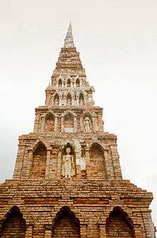 The Dvaravati-style chedi of Wat Phra That Hariphunchai
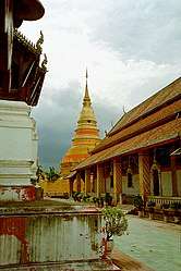 The viharn and golden chedi of Wat Phra That Hariphunchai
Notes
Reports (data) from Thai government are "not copyrightable" (Public Domain), Copyright Act 2537 (1994), section 7.
References
- "ประกาศสำนักนายกรัฐมนตรี เรื่อง แต่งตั้งข้าราชการพลเรือนสามัญ" [Announcement of the Prime Minister's Office regarding the appointment of civil servants] (PDF). Royal Thai Government Gazette. 136 (Special 242 Ngor). 21. 28 September 2019. Retrieved 24 November 2019.
- Advancing Human Development through the ASEAN Community, Thailand Human Development Report 2014, table 0:Basic Data (PDF) (Report). United Nations Development Programme (UNDP) Thailand. pp. 134–135. ISBN 978-974-680-368-7. Retrieved 17 January 2016, Data has been supplied by Land Development Department, Ministry of Agriculture and Cooperatives, at Wayback Machine.
- "รายงานสถิติจำนวนประชากรและบ้านประจำปี พ.ศ.2561" [Statistics, population and house statistics for the year 2018]. Registration Office Department of the Interior, Ministry of the Interior (in Thai). 31 December 2018. Retrieved 20 June 2019.
- Human achievement index 2017 by National Economic and Social Development Board (NESDB), pages 1-40, maps 1-9, retrieved 14 September 2019, ISBN 978-974-9769-33-1
- "Historic Lamphun: Capital of the Mon Kingdom of Haripunchai", in: Forbes, Andrew, and Henley, David, Ancient Chiang Mai Volume 4. Chiang Mai, Cognoscenti Books, 2012. ASIN: B006J541LE
- "Archived copy". Archived from the original on 2007-01-29. Retrieved 2008-07-20.CS1 maint: archived copy as title (link)
- Lamphun food : Kaeng Khae Kai
- "ก๋วยเตี๋ยวหมูตุ๋นลำไย (เวียงยอง) หลังวัดพระธาตุหริภุญไชย ลำพูน" [Longan stewed pork noodles (Wiang Yong) behind Wat Phra That Hariphunchai, Lamphun]. mu-ku-ra.com (in Thai). 2018-10-25.
- "Number of local government organizations by province". dla.go.th. Department of Local Administration (DLA). 26 November 2019. Retrieved 10 December 2019.
53 Lamphun: 1 PAO, 1 Town mun., 39 Subdistrict mun., 17 SAO.
External links

- Provincial website
- Lamphun Province, Tourism Authority of Thailand
Places adjacent to Lamphun Province | ||||||||||
|---|---|---|---|---|---|---|---|---|---|---|
| ||||||||||
| Authority control |
|
|---|