Si Sawat District
Si Sawat (Thai: ศรีสวัสดิ์, pronounced [sǐː sā.wàt]) is a district (amphoe) in Kanchanaburi Province, western Thailand.
Si Sawat ศรีสวัสดิ์ | |
|---|---|
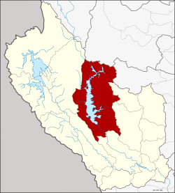 District location in Kanchanaburi Province | |
| Coordinates: 14°35′57″N 99°6′50″E | |
| Country | Thailand |
| Province | Kanchanaburi |
| Seat | Dan Mae Chalaep |
| Area | |
| • Total | 3,295.9 km2 (1,272.6 sq mi) |
| Population (2005) | |
| • Total | 23,700 |
| • Density | 7.2/km2 (19/sq mi) |
| Time zone | UTC+7 (ICT) |
| Postal code | 71250 |
| Geocode | 7104 |
Geography
Neighboring districts are (from the north clockwise) Ban Rai of Uthai Thani Province, Dan Chang of Suphanburi Province, Nong Prue, Bo Phloi, Kanchanaburi, Sai Yok and Thong Pha Phum of Kanchanburi Province.
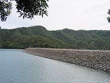
The district is dominated by the Si Nakharin Reservoir, which is part of Khuean Srinagarindra National Park. The 140-metre-high Si Nakharin Dam was finished in 1980 and creates a 419 km2 impoundment of the Kwae Yai River. The dam has received criticism for being built on the Si Sawat fault line.[1]
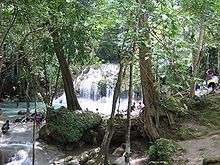
To the south of the district is Erawan National Park, best known for its Erawan Waterfall.
Administration
The district is divided into six sub-districts (tambons), which are further subdivided into 33 villages (mubans). The township (thesaban tambon) Erawan covers parts of tambon Tha Kradan. There are a further six tambon administrative organizations (TAO).
| 1. | Na Suan | นาสวน | 4,119 | ||
| 2. | Dan Mae Chalaep | ด่านแม่แฉลบ | 4,431 | ||
| 3. | Nong Pet | หนองเป็ด | 2,430 | ||
| 4. | Tha Kradan | ท่ากระดาน | 5,716 | ||
| 5. | Khao Chot | เขาโจด | 3,770 | ||
| 6. | Mae Krabung | แม่กระบุง | 3,234 |
References
- "What if the wall was to break". The Nation. 24 January 2002. Archived from the original on 29 September 2007. Retrieved 21 May 2013.
External links
- amphoe.com

|  | |