Uttaradit Province
Uttaradit (Thai: อุตรดิตถ์, pronounced [ʔùt.tā.rā.dìt]) is one of Thailand's seventy-six provinces (changwat), lies in upper northern Thailand. Neighboring provinces are (from south clockwise) Phitsanulok, Sukhothai, Phrae and Nan. To the east it borders Xaignabouli of Laos. Uttaradit is 488 km north of Bangkok, and 238 km southeast of Chiang Mai.
Uttaradit อุตรดิตถ์ | |
|---|---|
 Phraya Phichai Dap Hak Monument, in front of Uttaradit City Hall | |
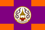 Flag 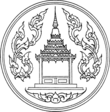 Seal | |
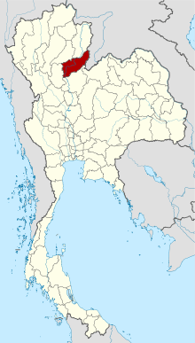 Map of Thailand highlighting Uttaradit Province | |
| Country | Thailand |
| Capital | Uttaradit town |
| Government | |
| • Governor | Thanakorn Ungchitphaisan |
| Area | |
| • Total | 7,839 km2 (3,027 sq mi) |
| Area rank | Ranked 25th |
| Population (2018)[2] | |
| • Total | 455,403 |
| • Rank | Ranked 60th |
| • Density | 58/km2 (150/sq mi) |
| • Density rank | Ranked 71st |
| Human Achievement Index | |
| • HAI (2017) | 0.5845 "average" Ranked 40th |
| Time zone | UTC+7 (ICT) |
| Postal code | 53xxx |
| Calling code | 055 |
| ISO 3166 code | TH-53 |
| Website | www |
History
Uttaradit means the "port of the north" or "northern landing", as it was formerly a trade center on the Nan River.[4]
In the Sukhothai era several city states (Mueang) subject to the king were in the area of the modern province. Mueang Fang was in modern-day Mueang Uttaradit district, Mueang Thung Yang in Laplae, and Mueang Ta Chuchok in Tron district.
During the Ayutthaya kingdom, Mueang Phichai was one of the 16 main Mueang of the Thai kingdom. In the reign of King Naresuan, the ruler of Phichai rebelled, joined by the ruler of Sawankhalok. Their revolt was suppressed and the inhabitants of both cities were forced to move south to Phitsanulok.
Following the fall of the city of Ayutthaya to the Burmese in 1767, Phichai was the site of several battles against the invaders. The ruler of Phichai succeeded in driving back the Burmese and was awarded the title Phraya Phichai Dap Hak - the "Lord of Pichai with a Broken Sword", as he had broken one of his swords in fierce hand-to-hand combat with the enemy.
In the reign of King Rama III Mueang Phichai controlled several Mueang of northern Siam like Nan or Phrae, and even Luang Prabang and Vientiane. At the point where the Nan river became shallow a port was established. As this town grew in importance as an important trade point, in 1887 it was made a Mueang subordinate of Phichai. 1899 the center of Phichai was moved to this new location, which was renamed to Uttaradit in 1915.[5]
Geography
The province is in the Nan River valley. About 45 kilometers north of the city of Uttaradit is the Queen Sirikit Dam, which created a 250 km² artificial lake. The Phi Pan Nam Range reaches the northwest of the province.
Most of the province was once covered with teak forests, then the major product of Uttaradit. The largest teak tree in the world is found at the Ton Sak Yai Park in the Luang Prabang Range.[6] The 1,500-year-old tree measures 9.87 m in circumference and 37 m in height. Originally it was 48.5 m high, but it was damaged in a storm.
Three national parks are located in the province—Klong Tron,[7] Lam Nam Nan,[8] and Phu Soi Dao.[9]
Symbols
The provincial seal shows the mondop at the temple Wat Phra Thaen Sila At, in Baan Phra Thaen in the Laplae district. The main item of worship in the temple is a laterite block, which is believed to have been used by Buddha to seek enlightenment. The mondhop is built upon this block.
The seal was first designed in 1940, later a garuda as the symbol of Thailand and the name of the province were added.
The provincial tree is the teak (Tectona grandis). The largest teak tree in the world stands in Sak Yai Forest Park (สักใหญ่). The tree, estimated to be more than 1,500 years old, is 37 meters high and has a circumference of 9.58 meters at its base. Although the upper part of the tree broke off in a storm, the trunk is still alive. Discovered in 1927, the giant teak tree is part of the 35 square kilometer park of mixed deciduous forest.[10]
Administrative divisions
Provincial government
The province is divided into nine districts (amphoe). These are further divided into 67 subdistricts (tambon) and 562 villages (muban).
Local government
As of 26 November 2019 there are[11]: one Uttaradit Provincial Administration Organisation (ongkan borihan suan changwat) and 26 municipal (thesaban) areas in the province. Uttaradit has town (thesaban mueang) status. Further 25 subdistrict municipalities (thesaban tambon). The non-municipal areas are administered by 53 Subdistrict Administrative Organisations - SAO (ongkan borihan suan tambon).[2]
Health
Uttaradit's main hospital is Uttaradit Hospital, operated by the Ministry of Public Health.
Economy
Uttaradit is largely an agricultural province. Among its best known crops are two fruits: durian and langsat. A durian festival is held each year around the beginning of June in Laplae District. The province is known for two varieties of durian which lack the usual, and to some people offensive, odour: Longlaplae and Linlaplae, both named after Laplae District. Durian production in Uttaradit province was estimated to be around 20,000 tonnes in 2012. The province has approximately 10,600 acres of durian orchards.[12]
The langsat (ลางสาด) (Lansium parasiticum), for which Uttaradit is famous, and its thick-skinned sibling, longkong (ลองกอง) , is a fruit that is similar in taste to the longan.[13] A langsat festival is held each year around the middle to end of September.[14]
Transport
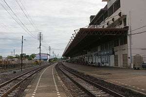
Uttaradit is served by the Northern Line of the State Railway of Thailand. There are two stations in Uttaradit town: Uttaradit railway station, the main station and Sila At railway station, where it is a major centre for Northern Line operations. It does not have an airport. The nearest airport is in Phitsanulok Province.
Human achievement index 2017
| Health | Education | Employment | Income |
| 70 | 29 | 73 | 46 |
| Housing | Family | Transport | Participation |
 |
 |
||
| 47 | 15 | 36 | 8 |
| Province Uttaradit, with an HAI 2017 value of 0.5845 is "average", occupies place 40 in the ranking. | |||
Since 2003, United Nations Development Programme (UNDP) in Thailand has tracked progress on human development at sub-national level using the Human achievement index (HAI), a composite index covering all the eight key areas of human development. National Economic and Social Development Board (NESDB) has taken over this task since 2017.[3]
| Rank | Classification |
| 1 - 15 | "high" |
| 16 - 30 | "somewhat high" |
| 31 - 45 | "average" |
| 45 - 60 | "somewhat low" |
| 61 - 77 | "low" |
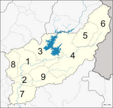
| Map with provinces and HAI 2017 rankings |
 |
Gallery
| Wikimedia Commons has media related to Uttaradit Province. |
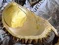 Durian long laplae, Uttaradit Province
 Khao phan, found only in Uttaradit Province
 Bronze Buddha, Wat Phra Yun Phutthabat Yukhon
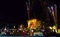 Atthami Bucha Festival, cremation of the Buddha
 Sirikit Dam
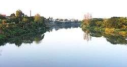 Nan River, Uttaradit
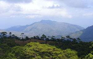 Hill 1428, scene of the Thai–Laotian Border War, Dec 1987 – Feb 1988

Notes
Reports (data) from Thai government are "not copyrightable" (Public Domain), Copyright Act 2537 (1994), section 7.
References
- Advancing Human Development through the ASEAN Community, Thailand Human Development Report 2014, table 0:Basic Data (PDF) (Report). United Nations Development Programme (UNDP) Thailand. pp. 134–135. ISBN 978-974-680-368-7. Retrieved 17 January 2016, Data has been supplied by Land Development Department, Ministry of Agriculture and Cooperatives, at Wayback Machine.
- "รายงานสถิติจำนวนประชากรและบ้านประจำปี พ.ศ.2561" [Statistics, population and house statistics for the year 2018]. Registration Office Department of the Interior, Ministry of the Interior (in Thai). 31 December 2018. Retrieved 20 June 2019.
- Human achievement index 2017 by National Economic and Social Development Board (NESDB), pages 1-40, maps 1-9, retrieved 14 September 2019, ISBN 978-974-9769-33-1
- "Uttaradit". Tourism Authority of Thailand (TAT). Retrieved 20 Apr 2015.
- ประกาศ เปลี่ยนนามเมืองพิไชย เป็นเมืองอุตรดิฐ (PDF). Royal Gazette (in Thai). 32 (0 ก): 178. August 22, 1915.
- ดร.กระมล ทองธรรมชาติ และคณะ, สังคมศึกษา ศาสนาและวัฒนธรรม ม.1, สำนักพิมพ์ อักษรเจริญทัศน์ อจท. จำกัด, 2548, หน้า 24-25
- "Khlong Tron National Park". Department of National Parks (DNP) Thailand. Archived from the original on 27 April 2015. Retrieved 20 April 2015.
- "Lam Nam Nan National Park". Department of National Parks (DNP) Thailand. Archived from the original on 9 November 2013. Retrieved 20 April 2015.
- "Phu Soi Dao National Park". Department of National Parks (DNP) Thailand. Archived from the original on 27 April 2015. Retrieved 20 April 2015.
- "Sak Yai Forest Park". Tourism Authority of Thailand (TAT). Retrieved 23 July 2018.
- "Number of local government organizations by province". dla.go.th. Department of Local Administration (DLA). 26 November 2019. Retrieved 10 December 2019.
73 Uttaradit: 1 PAO, 1 Town mun., 25 Subdistrict mun., 53 SAO.
- http://www.pattayamail.com/news/ordourless-seedless-durians-developed-in-uttaradit-12939 Pattayamail.com: Ordourless, seedless durians developed in Uttaradit, retrieved: 2012-06-21
- Ekachai, Sanitsuda (15 September 2018). "Seeing the langsat for the trees". Bangkok Post. Retrieved 15 September 2018.
- "Uttaradit Langsat Festival: 16-25 September 2011". Archived from the original on October 30, 2012. Retrieved June 21, 2012.
External links

- Website of the province (Thai only)
Places adjacent to Uttaradit Province | ||||||||||
|---|---|---|---|---|---|---|---|---|---|---|
| ||||||||||