Rayong Province
Rayong Province (Thai: ระยอง, pronounced [rā.jɔ̄ːŋ]) is one of seventy-six provinces (changwat) lies in eastern Thailand. Neighboring provinces are (from west clockwise) Chonburi, and Chanthaburi. To the south is the Gulf of Thailand.[4]
Rayong ระยอง | |
|---|---|
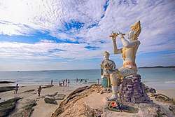 The statues of Phra Aphamani and the mermaid, characters from a famous Thai epic poem, on Ko Samet | |
 Flag  Seal | |
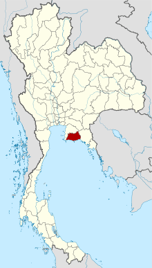 Map of Thailand highlighting Rayong Province | |
| Country | Thailand |
| Capital | Rayong |
| Government | |
| • Governor | Surasak Charoensirichot (since October 2016) |
| Area | |
| • Total | 3,552 km2 (1,371 sq mi) |
| Area rank | Ranked 57th |
| Population (2018)[2] | |
| • Total | 723,316 |
| • Rank | Ranked 35th |
| • Density | 203.6/km2 (527/sq mi) |
| • Density rank | Ranked 14th |
| Human Achievement Index | |
| • HAI (2017) | 0.6578 "high" Ranked 8th |
| Time zone | UTC+7 (ICT) |
| Postal code | 21xxx |
| Calling code | 038 |
| ISO 3166 code | TH-21 |
As of 2016, per capita earnings were higher in Rayong Province than in any other Thai province.[5]
History
King Taksin (of Thailand) came to Rayong after the fall of Ayutthaya. During a short stay in Rayong he built a navy, and then went on to Chanthaburi to assemble forces to fight the Burmese. There is a shrine in Rayong where local people pay their respects to Taksin.
Geography

Although the north is hilly, the province consists mostly of low coastal plains. Off the shoreline of Mueang Rayong District is Khao Laem Ya–Mu Ko Samet National Park, consisting of several islands.
Symbols
The seal of the province shows the island Ko Samet. The provincial tree is Alexandrian laurel (Calophyllum inophyllum).
Economy
Rayong is one of the three Thai provinces, together with Chonburi and Chachoengsao, at the center of the nation's Eastern Economic Corridor. The three provinces are to become Thailand's hub for manufacturing, research, and services tightly coupled with its ASEAN neighbors and the world logistically. [6] The project is the centerpiece of the government's "Thailand 4.0" economic initiative.[7][8]
Administrative divisions

Provincial government
The province is divided into eight districts (amphoes). These are further divided into 58 subdistricts (tambons) and 388 villages (mubans).
Local government
As of 21 November 2019 there are[9] : one Rayong Provincial Administrative Organization - PAO (ongkan borihan suan changwat) and 30 municipal (thesaban) areas in the province. The capital Rayong has city (thesaban nakhon) status. Ban Chang and Map Ta Phut have town (thesaban mueang) status and 27 subdistrict municipalities (thesaban tambon).[2] The non-municipal areas are administered by 37 Subdistrict Administrative Organizations - SAO (ongkan borihan suan tambon).
Human achievement index 2017
| Health | Education | Employment | Income |
| 16 | 7 | 4 | 9 |
| Housing | Family | Transport | Participation |
 |
 |
||
| 67 | 44 | 6 | 68 |
| Province Rayong, with an HAI 2017 value of 0.6578 is "high", occupies place 8 in the ranking. | |||
Since 2003, United Nations Development Programme (UNDP) in Thailand has tracked progress on human development at sub-national level using the Human achievement index (HAI), a composite index covering all the eight key areas of human development. National Economic and Social Development Board (NESDB) has taken over this task since 2017.[3]
| Rank | Classification |
| 1 - 15 | "high" |
| 16 - 30 | "somewhat high" |
| 31 - 45 | "average" |
| 45 - 60 | "somewhat low" |
| 61 - 77 | "low" |
| Map with provinces and HAI 2017 rankings |
 |
Notes
Reports (data) from Thai government are "not copyrightable" (Public Domain), Copyright Act 2537 (1994), section 7.
Gallery
 The cape of Khao Laem Ya in the morning, Khao Laem Ya – Mu Ko Samet National Park
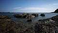 Khao Laem Ya – Mu Ko Samet National Park
 Khao Laem Ya – Mu Ko Samet National Park
 Khao Laem Ya – Mu Ko Samet National Park
 Khao Laem Ya – Mu Ko Samet National Park
 Khao Laem Ya – Mu Ko Samet National Park
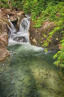 Khao Chamao (Khlong Nam Sai) Waterfall, Khao Chamao–Khao Wong National Park
References
- Advancing Human Development through the ASEAN Community, Thailand Human Development Report 2014, table 0:Basic Data (PDF) (Report). United Nations Development Programme (UNDP) Thailand. pp. 134–135. ISBN 978-974-680-368-7. Retrieved 17 January 2016, Data has been supplied by Land Development Department, Ministry of Agriculture and Cooperatives, at Wayback Machine.
- "ร่ยงานสถิติจำนวนประชากรและบ้านประจำปี พ.ศ.2561" [Statistics, population and house statistics for the year 2018]. Registration Office Department of the Interior, Ministry of the Interior. stat.bora.dopa.go.th (in Thai). 31 December 2018. Retrieved 20 June 2019.
- Human achievement index 2017 by National Economic and Social Development Board (NESDB), pages 1-40, maps 1-9, retrieved 14 September 2019, ISBN 978-974-9769-33-1
- "About Rayong". Tourism Authority of Thailand (TAT). Retrieved 1 July 2019.
- "Gross Regional and Provincial Product 2016 Edition". National Economic and Social Development Board (NESDB). Retrieved 2 July 2019.
- Dunseith, Bradley (29 June 2018). "Thailand's Eastern Economic Corridor – What You Need to Know". ASEAN Briefing. Retrieved 1 July 2019.
- "Opportunity Thailand" (PDF). Thailand Board of Investment. Retrieved 1 July 2019.
- Lopez, Leslie (24 July 2017). "Thai junta aims to make eastern economic hub its legacy". Straits Times. Retrieved 1 July 2019.
- "Number of local government organizations by province". dla.go.th. Department of Local Administration (DLA). 26 November 2019. Retrieved 10 December 2019.
49 Rayong: 1 PAO, 1 City mun., 2 Town mun., 27 Subdistrict mun., 37 SAO.
External links

- Provincial Website (Thai)
- Eastern Economic Corridor (EEC) Office
Places adjacent to Rayong Province | ||||||||||
|---|---|---|---|---|---|---|---|---|---|---|
| ||||||||||
| Wikimedia Commons has media related to Rayong Province. |