Eastern Thailand
Eastern Thailand is a region of Thailand bordering Cambodia on the east, Northeastern Thailand in the north, and central Thailand on the west.
Eastern Region | |
|---|---|
     From upper-left to lower-right: Pattaya in daytime, Port of Laem Chabang, Khao Khitchakut, Ko Chang and Wat Sothonwararam | |
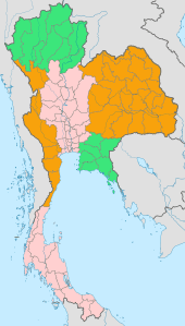
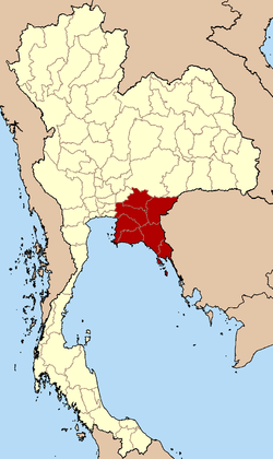 Eastern Region in Thailand | |
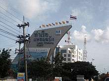
| Largest city | Chaophraya Surasak City |
| Provinces | |
| Area | |
| • Total | 34,380 km2 (13,270 sq mi) |
| Population (2018)[2] | |
| • Total | 4,795,912 |
| • Density | 140/km2 (360/sq mi) |
| Time zone | UTC+7 (Thailand) |
Geography
Eastern Thailand lies between the Sankamphaeng Range, which forms a natural border with the Khorat Plateau to the north and the Gulf of Thailand to the south. The geography of the region is characterised by short mountain ranges (collectively grouped under the Chanthaburi Range) alternating with small basins of short rivers which drain into the Gulf of Thailand. Between the Chanthaburi and Sankamphaeng mountains lies the basin of the Bang Pakong River system.
Fruit is a major component of agriculture in the area, and tourism plays a strong part in the economy. The region's coastal location has helped promote eastern seaboard industrial development, a major factor in the economy of the region.[3]
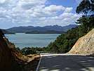
Islands off Eastern Thailand's coast include Ko Sichang, Ko Lan, Ko Samet, and Ko Chang.
National parks
Within the eastern region there are some eight national parks. Pang Sida National Park covering 844 km2 in Sa Kaeo province, it constitutes a part of the Dong Phayayen-Khao Yai Forest Complex UNESCO World Heritage Site, covering in total around 6,100 km2. Mu Ko Chang National Park in Trat province includes 85 per cent of Thailands second largest island Ko Chang. The beaches on the western coast of Ko Chang have been excluded from the national park for reason of facilitating the tourism industry. Mu Ko Samet National Park in Rayong province is just 6 km long by 3 km wide with beaches covered with some of the finest white sand in the country.
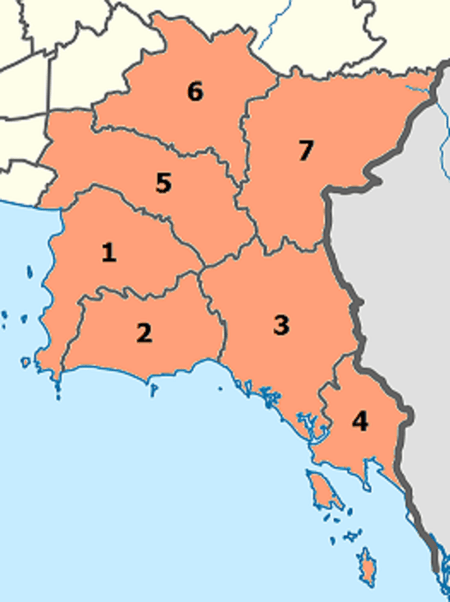
Administrative divisions
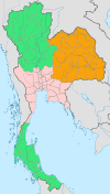
According to the six geographical regions established by the National Research Council of Thailand, the eastern region includes seven provinces.

The Thai Meteorological Department and the Office of the National Economic and Social Development Council[4] both also include province Nakhon Nayok in the Eastern region.
| Flag | Seal | Province | Capital | DOPA | Popul. | Area (km2) |
Dens. | ISO | |
|---|---|---|---|---|---|---|---|---|---|
 |
 |
1 | Chonburi | Chonburi | 9 | 1,535,445 | 4,363 | 352 | TH-20 |
 |
|
2 | Rayong | Rayong | 50 | 723,316 | 3,552 | 204 | TH-21 |
 |
 |
3 | Chanthaburi | Chanthaburi | 7 | 536,496 | 6,338 | 85 | TH-22 |
 |
 |
4 | Trat | Trat | 16 | 229,914 | 2,819 | 82 | TH-23 |
 |
 |
5 | Chachoengsao | Chachoengsao | 8 | 715,009 | 5,351 | 134 | TH-24 |
 |
6 | Prachin Buri | Prachin Buri | 31 | 491,640 | 4,762 | 103 | TH-25 | |
 |
 |
7 | Sa Kaeo | Sa Kaeo | 63 | 564,092 | 7,195 | 78 | TH-27 |
Population is based on "Statistics, population and house statistics for the year 2018" from Registration Office Department of the Interior. Reference date is 31 December 2018.[2]
Area is based on "Data that has been supplied by Land Development Department, Ministry of Agriculture and Cooperatives.[1]
References
- Advancing Human Development through the ASEAN Community, Thailand Human Development Report 2014, table 0:Basic Data (PDF) (Report). United Nations Development Programme (UNDP) Thailand. pp. 134–135. ISBN 978-974-680-368-7. Retrieved 17 January 2016Data has been supplied by Land Development Department, Ministry of Agriculture and Cooperatives. Thai state data are public domain.
- "ร่ยงานสถิติจำนวนประชากรและบ้านประจำปี พ.ศ.2561" [Statistics, population and house statistics for the year 2018]. Registration Office Department of the Interior, Ministry of the Interior (in Thai). 31 December 2018. Retrieved 20 June 2019.
- Eastern Seaboard Development Programme - Rayong Archived March 8, 2016, at the Wayback Machine
- "National account". p. 37. Retrieved 6 August 2019.
External links

See also
- Regions of Thailand
- Eastern Seaboard of Thailand
 | Four-region division system |
|  |
|---|---|---|---|
| Six-region division system |
| ||