Narathiwat Province
Narathiwat (Thai: นราธิวาส, pronounced [nā.rāː.tʰí.wâːt]) is one of the southern provinces (changwat) of Thailand. Neighboring provinces are (from west clockwise) Yala and Pattani. To the south it borders the Malaysian state of Kelantan and Perak. The southern railway line ends in this province, which is one of the nation's four provinces that border Malaysia.[4] The province features a range of cultures as well as natural resources, and is relatively fertile. Narathiwat is about 1,140 kilometers south of Bangkok and has an area of 4,475 km2 (1,728 sq mi). Seventy-five percent of the area is jungle and mountains and has a tropical climate.
Narathiwat | |
|---|---|
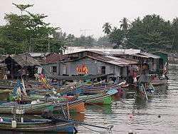 Fishing village in Narathiwat | |
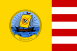 Flag  Seal | |
| Nickname(s): Bang Nara | |
 Map of Thailand highlighting Narathiwat Province | |
| Country | Thailand |
| Capital | Narathiwat |
| Government | |
| • Governor | Ekkarat Leesen (since 2018) |
| Area | |
| • Total | 4,475 km2 (1,728 sq mi) |
| Area rank | Ranked 49th |
| Population (2018)[2] | |
| • Total | 802,474 |
| • Rank | Ranked 31st |
| • Density | 179/km2 (460/sq mi) |
| • Density rank | Ranked 18th |
| Human Achievement Index | |
| • HAI (2017) | 0.4800 "low" Ranked 76th |
| Time zone | UTC+7 (ICT) |
| Postal code | 96xxx |
| Calling code | 073 |
| ISO 3166 code | TH-96 |
| Website | www |
Geography
Narathiwat Province is on the Gulf of Thailand, on the Malay Peninsula. The Bang Nara is the main river and enters the Gulf of Thailand at the town of Narathiwat. Narathat Beach, the most popular in the province, is near the estuary.
Budo–Su-ngai Padi National Park is in the Sankalakhiri mountain range. Established in 1974, the park covers an area of 294 km2 (114 sq mi), extending into neighbouring Yala and Pattani Provinces. The main attraction is Pacho Waterfall.[5]
Toponymy
The former name of Narathiwat was Menara (Jawi: منارا), meaning a 'minaret' in Malay, the pre-Islamic name is unknown. This became Bang Nara (Thai: บางนรา) or Bang Nak (Thai: บางนาค) in Thai,[6] but was changed to Narathiwat by King Rama VI in 1915.[7] "Narathiwat", from the Sanskrit (Nara+adhivāsa), means the residence of wise people. Today, traffic signs in Malaysia still use Menara.
History
Historically, Narathiwat was the part of the semi-independent Malay Sultanate of Patani, paying tribute to the Thai kingdoms of Sukhothai and Siamese Ayutthaya Kingdom. After Ayutthaya fell in 1767, the Sultanate of Patani gained full independence, but under King Rama I it again came under Thai control 18 years later and in the early–1800s was divided into seven smaller kingdoms.
In 1909, Narathiwat was fully integrated into Siam as part of Anglo-Siamese Treaty of 1909 negotiated with the British Empire. Along with Yala, Narathiwat was then part of Monthon Pattani.
Demographics
Narathiwat is one of four Thai provinces (along with Yala, Pattani, and Satun) with a predominantly Muslim population; 82% are Muslim and 17.9% are Buddhist. Also 80.4% speak the Patani Malay as their first language.[4] Narathiwat Malays are very similar in ethnicity and culture to the Malays of Kelantan, Malaysia.
In 1963, the Thai government launched the Nikhom Sang Ton Eng Pak Tai ('self-development community in the south') program to move families from Thailand's northeastern and central provinces to the Sukhirin and Chanae Districts of Narathiwat. A total of 5,633 families were relocated to Narathiwat, where each family was rewarded with 18 rai of land. In Phukhao Thong Subdistrict as of 2019, most inhabitants migrated from the northeast. They speak Isan and are 90% Buddhist in what is a predominantly Muslim province.[8]
The inhabitants of Narathiwat are largely farmers and fishermen.[9] Narathiwat is an area with various religious places of historical significance.
Symbols
The provincial seal shows a sailing boat with a white elephant on the sail. A white elephant is a royal symbol, and was put on the seal to commemorate the white elephant Phra Sri Nararat Rajakarini which was caught here and presented to the king.
The provincial symbol is the longkong fruit (Lansium parasiticum). The provincial tree is the Chengal (Neobalanocarpus heimii), and the provincial flower is the Odontadenia macrantha.
Administrative divisions
Provincial government
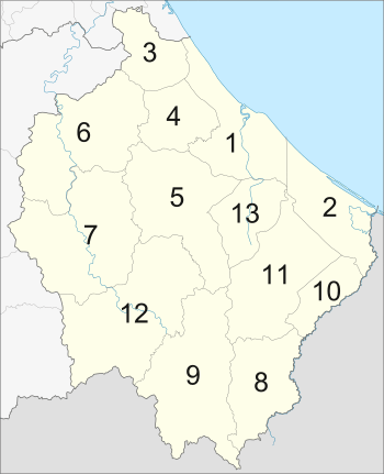
Narathiwat is divided into 13 districts (amphoe), which are further divided into 77 subdistricts (tambon) and 551 villages (muban).
| No | Name | Thai |
| 1 | Narathiwat | เมืองนราธิวาส |
| 2 | Tak Bai | ตากใบ |
| 3 | Bacho | บาเจาะ |
| 4 | Yi-ngo | ยี่งอ |
| 5 | Ra-ngae | ระแงะ |
| 6 | Rueso | รือเสาะ |
| 7 | Si Sakhon | ศรีสาคร |
| 8 | Waeng | แว้ง |
| 9 | Sukhirin | สุคิริน |
| 10 | Su-ngai Kolok | สุไหงโก-ลก |
| 11 | Su-ngai Padi | สุไหงปาดี |
| 12 | Chanae | จะแนะ |
| 13 | Cho-airong | เจาะไอร้อง |
Local government
As of 26 November 2019 there are:[10] one Narathiwat Provincial Administration Organisation (ongkan borihan suan changwat) and 16 municipal (thesaban) areas in the province. Narathiwat, Sungai Kolok and Tak Bai have town (thesaban mueang) status. Further 13 subdistrict municipalities (thesaban tambon). The non-municipal areas are administered by 72 Subdistrict Administrative Organisations - SAO (ongkan borihan suan tambon).[2]
Transportation
Air
Narathiwat Airport has a direct flight from and to Bangkok daily, operated by Air Asia, departing from Bangkok in the morning and leaving Narathiwat for Bangkok in the afternoon. It also has Thai Smile from Narathiwat to Suvanrabhumi airport.[11]
Rail
Although there is no direct access to Mueang Narathiwat District, Narathiwat's main railway station and nearest to Mueang District is Tanyong Mat Railway Station, on the Southern Line, in Ra-ngae District. Other major stations along the line in Narathiwat include Rueso, Su-ngai Kolok, Su-ngai Padi and Cho-airong. Distance to Narathiwat by rail is roughly 1100 kilometres from Bangkok Railway Station.
Health
Narathiwat is mostly served by public hospitals. Its main hospital is Naradhiwas Rajanagarindra Hospital and the province has one university hospital which is Galyanivadhanakarun Hospital of the Faculty of Medicine, Princess of Naradhiwas University.
Human achievement index 2017
| Health | Education | Employment | Income |
| 68 | 77 | 53 | 77 |
| Housing | Family | Transport | Participation |
 |
 |
||
| 38 | 32 | 75 | 35 |
| Province Narathiwat, with an HAI 2017 value of 0.4800 is "low", occupies place 76 in the ranking. | |||
Since 2003, United Nations Development Programme (UNDP) in Thailand has tracked progress on human development at sub-national level using the Human achievement index (HAI), a composite index covering all the eight key areas of human development. National Economic and Social Development Board (NESDB) has taken over this task since 2017.[3]
| Rank | Classification |
| 1 - 15 | "high" |
| 16 - 30 | "somewhat high" |
| 31 - 45 | "average" |
| 45 - 60 | "somewhat low" |
| 61 - 77 | "low" |
| Map with provinces and HAI 2017 rankings |
 |
Recent history
There has been growing violence in southern Thailand since 4 January 2004, especially in the majority Muslim provinces of Narathiwat, Yala, and Pattani. Most of the inhabitants of these provinces are ethnic Malays, though the cities are mainly Thai, Thai Chinese, and Indian. Violent mujahideen activity has happened since the 1980s, but this lessened when Thaksin Shinawatra became prime minister in 2001.
Most of the violence has been directed towards the minority Buddhist population in the province.
The government has been suspected of organising violent attacks on Muslims. On 8 June 2009, at least 10 died in a shooting during Muslim evening prayers. Five or six gunmen disguised by ski masks attacked a mosque. The army denied involvement.[12]
Religious sites
Central Mosque of Narathiwat
The important religious site for Muslims is the central mosque of Narathiwat. This mosque is on Pitchitbamrung Road, Tambon Bangnark, Amphoe Muang, about 1 kilometer from the provincial town. This mosque is the center for Thai Muslims who come to worship on Fridays. It was built in 1981 in a three-storied Arabian-style building with a high tower and a domed roof as other mosques. The tower is used to call Muslims to prayer.[13]
Khao Kong Buddhist Park
A minority of the people in Narathiwat are Buddhist. Although a minority, there are Buddhist temples in the same amphoe as the mosque. The most famous one is Khao Kong Buddhist Park. It occupies an area of 142 rai (227,200 square metres (2,446,000 sq ft)) in Tambon Lamphu about nine kilometers from town on the Narathiwat-Rangae Road.[4]
Phra Buddha Thaksin Ming Mongko
The main attraction in this site is a southern Buddha image, the golden "Pra Buddha Thaksin Ming Monkol",[13] which is seated in the lotus position and giving posture. "This mountaintop Buddha image which is considered to be the most beautiful and largest (17 meters wide and 24 meters high) outdoor Buddha image in southern Thailand is decorated in the South Indian style".[4] It is highly respected by locals and Buddhists in the south.[9]
Notable Residents
- Attachai Anantameak, actor and political activist
Notes
Reports (data) from Thai government are "not copyrightable" (Public Domain), Copyright Act 2537 (1994), section 7.
References
- Advancing Human Development through the ASEAN Community, Thailand Human Development Report 2014, table 0:Basic Data (PDF) (Report). United Nations Development Programme (UNDP) Thailand. pp. 134–135. ISBN 978-974-680-368-7. Retrieved 17 January 2016, Data has been supplied by Land Development Department, Ministry of Agriculture and Cooperatives, at Wayback Machine.
- "รายงานสถิติจำนวนประชากรและบ้านประจำปี พ.ศ.2561" [Statistics, population and house statistics for the year 2018]. Registration Office Department of the Interior, Ministry of the Interior (in Thai). 31 December 2018. Retrieved 20 June 2019.
- Human achievement index 2017 by National Economic and Social Development Board (NESDB), pages 1-40, maps 1-9, retrieved 14 September 2019, ISBN 978-974-9769-33-1
- "Narathiwat". Tourism Authority of Thailand (TAT). Retrieved 18 May 2018.
- "Budo–Su-ngai Padi National Park". National Park, Wildlife and Plant Conservation Department. Archived from the original on 2015-07-10.
- ประพนธ์ เรืองณรงค์. "บทผนวกเกียรติยศ". ใน รัฐปัตตานีใน "ศรีวิชัย" เก่าแก่กว่ารัฐสุโขทัยในประวัติศาสตร์. สุจิตต์ วงษ์เทศ (บรรณาธิการ). พิมพ์ครั้งที่ 2. กรุงเทพฯ:มติชน. 2547, หน้า 350
- ประกาศ เปลี่ยนชื่อเมืองบางนรา เป็นเมืองนราธิวาส (PDF). Royal Gazette (in Thai). 32 (0 ก): 145. August 8, 1915.
- Karnjanatawe, Karnjana (5 September 2019). "Seeking fortune in paradise". Bangkok Post. Retrieved 7 September 2019.
- Tasanasuwan, P. (1991). Changwat kong rao sib see changwat pak tai [Our province 14 provinces in the South]. Bangkok: Thai Watana Panitch
- "Number of local government organizations by province". dla.go.th. Department of Local Administration (DLA). 26 November 2019. Retrieved 10 December 2019.
24 Narathiwat: 1 PAO, 3 Town mun., 13 Subdistrict mun., 72 SAO.
- https://www.thaismileair.com/en/booking
- "Army denies role in Thai attack". BBC News. June 9, 2009. Retrieved April 6, 2010.
- Government of Narathiwat. (2000). Narathiwat Thailand [Brochure]. Narathiwat: Author.
External links
| Wikimedia Commons has media related to Narathiwat Province. |
- http://www.narathiwat.go.th/ Website of province (Thai)
- Province page from the Tourist Authority of Thailand
- Southern Comforts; Narathiwat Province (article in The Nation)
Places adjacent to Narathiwat Province | ||||||||||
|---|---|---|---|---|---|---|---|---|---|---|
| ||||||||||