Pathum Thani Province
Pathum Thani (Thai: ปทุมธานี, pronounced [pā.tʰūm tʰāːnīː]) is one of the central provinces (changwat) of Thailand. Neighboring provinces are (from north clockwise): Ayutthaya, Saraburi, Nakhon Nayok, Chachoengsao, Bangkok, and Nonthaburi.
Pathum Thani ปทุมธานี | |
|---|---|
.jpg)  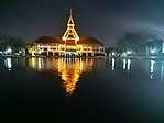  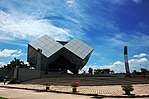 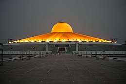 (clockwise from top left) Thailand National Memorial, A Royal Ploughing Ceremony exhibition in Golden Jubilee Museum of Agriculture, Tornado ride in the Dream World, Wat Phra Dhammakaya, National Science Museum, Wat Phra Dhammakaya | |
 Flag  Seal | |
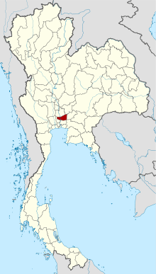 Map of Thailand highlighting Pathum Thani Province | |
| Country | Thailand |
| Region | Central Thailand |
| Capital | Pathum Thani |
| Largest City | Rangsit |
| Government | |
| • Governor | Surachai Khan-asa (since October 2015-present) |
| Area | |
| • Total | 1,526 km2 (589 sq mi) |
| Area rank | Ranked 70th |
| Population (2018)[2] | |
| • Total | 1,146,092 |
| • Rank | Ranked 18th |
| • Density | 751,0/km2 (19,500/sq mi) |
| • Density rank | Ranked 5th |
| Human Achievement Index | |
| • HAI (2017) | 0.6384 "high" Ranked 10th |
| Time zone | UTC+7 (ICT) |
| Postal code | 10xxx |
| Calling code | 02 |
| ISO 3166 code | TH-13 |
| Website | www |
The province is north of Bangkok and is part of the Bangkok metropolitan area. In many places the boundary between the two provinces is not noticeable as both sides of the boundary are equally urbanized. Pathum Thani town is the administrative seat, but Ban Rangsit, seat of Thanyaburi District, is the largest populated place in the province.[4]
Pathum Thani is an old province, heavily populated by the Mon people, dotted with 186 temples and parks. The Dream World amusement park is here.
Geography
The province lies on the low alluvial flats of the Chao Phraya River that flows through the capital. Many canals (khlongs) cross the province and feed the rice paddies.
History
The city dates back to a settlement founded by Mon migrating from Mottama (Thai: เมาะตะมะ) in Myanmar around 1650. The original name was Sam Khok.[5]:230,369 In 1815 King Rama II visited the city and the citizens offered him many lotus flowers, which prompted the king to rename the city Pathum Thani, meaning 'lotus flower town'.[6]
Symbols
The provincial seal shows a pink lotus flower with two rice stalks bending over it, representing the fertility of the province. The provincial tree is the Indian coral tree (Erythrina variegata). The provincial flower is the lotus (Nymphaea lotus).
Education and technology
Pathum Thani has a very high concentration of higher education institutions, especially ones in the field of science and technology. This, together with a large number of industrial parks and research facilities (including those in Thailand Science Park), make the region the educational and technology hub of the area.
- Academic institutes
- National Science Museum, Asian Institute of Technology, Bangkok University, Eastern Asia University, North Bangkok University (Rangsit), Pathumthani University, Rajamangala University of Technology, Rangsit University, Shinawatra University, Sirindhorn International Institute of Technology, Thammasat University (Rangsit Center, and Valaya Alongkorn - Rajahbaht University).
- Research bodies
- Thailand Science Park, National Science and Technology Development Agency (NSTDA), National Center for Genetic Engineering and Biotechnology (BIOTEC), National Metal and Materials Technology Center (MTEC), National Nanotechnology Center (NANOTEC), National Electronics and Computer Technology Center (NECTEC), Thai Microelectronics Center (TMEC), Thailand Institute of Scientific and Technological Research (TISTR), TOT Innovation Institute (TOT)
- Industrial parks
- Software Park Thailand (in Nonthaburi, southwest of Pathum Thani), Nava Nakorn Industrial Promotion Zone (1376 acres / 5.6 km²), Bangkadi Industrial Park (470 acres / 1.9 km²), Techno Thani (a "Technology City" administered by the Ministry of Science and Technology), and a number of industrial parks in neighboring Ayutthaya and Nonthaburi Provinces
Administrative divisions
Provincial government

The province is divided into seven districts (amphoes). The districts are further subdivided into 60 communes (tambons) and 529 villages (mubans).
Local government
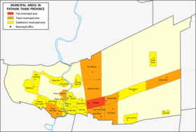
As of 26 November 2019 there are[7]: one Pathum Thani Provincial Administrative Organization - PAO (ongkan borihan suan changwat) and twenty-seven municipal (thesaban) areas in the province. Rangsit has city (thesaban nakhon) status. Further nine have town (thesaban mueang) status and seventeen subdistrict municipalities (thesaban tambon).[2]
| # | City municipality | 1 | Rangsit[8] |
| # | Town municipalities | 5 | Bueng Yi Tho[9] |
| 1 | Bang Khu Wat | 6 | Sanan Rak[10] |
| 2 | Pathum Thani | 7 | Lam Sam Kaeo |
| 3 | Tha Khlong[11] | 8 | Lat Sawai |
| 4 | Khlong Luang[12] | 9 | Khu Khot[13] |
| # | Subdistrict mun. | 9 | Thanyaburi |
| 1 | Bang Phun | 10 | Nong Suea |
| 2 | Lak Hok | 11 | Rahaeng |
| 3 | Bang Khayaeng | 12 | Khlong Phra Udom |
| 4 | Bang Duea | 13 | Khu Khwang |
| 5 | Ban Mai | 14 | Lam Luk Ka |
| 6 | Bang Kadi | 15 | Lam Sai |
| 7 | Ban Klang | 16 | Sam Khok |
| 8 | Bang Luang | 17 | Bang Toei |
The non-municipal areas are administered by 37 Subdistrict Administrative Organizations - SAO (ongkan borihan suan tambon).
Human achievement index 2017
| Health | Education | Employment | Income |
| 4 | 11 | 38 | 13 |
| Housing | Family | Transport | Participation |
 |
 |
||
| 68 | 8 | 3 | 76 |
| Province Pathum Thani, with an HAI 2017 value of 0.6384 is "high", occupies place 10 in the ranking. | |||
Since 2003, United Nations Development Programme (UNDP) in Thailand has tracked progress on human development at sub-national level using the Human achievement index (HAI), a composite index covering all the eight key areas of human development. National Economic and Social Development Board (NESDB) has taken over this task since 2017.[3]
| Rank | Classification |
| 1 - 15 | "high" |
| 16 - 30 | "somewhat high" |
| 31 - 45 | "average" |
| 45 - 60 | "somewhat low" |
| 61 - 77 | "low" |
| Map with provinces and HAI 2017 rankings |
 |
Notes
Reports (data) from Thai government are "not copyrightable" (Public Domain), Copyright Act 2537 (1994), section 7.
References
- Advancing Human Development through the ASEAN Community, Thailand Human Development Report 2014, table 0:Basic Data (PDF) (Report). United Nations Development Programme (UNDP) Thailand. pp. 134–135. ISBN 978-974-680-368-7. Retrieved 17 January 2016, Data has been supplied by Land Development Department, Ministry of Agriculture and Cooperatives, at Wayback Machine.
- "รายงานสถิติจำนวนประชากรและบ้านประจำปี พ.ศ.2561" [Statistics, population and house statistics for the year 2018]. Registration Office Department of the Interior, Ministry of the Interior (in Thai). 31 December 2018. Retrieved 20 June 2019.
- Human achievement index 2017 by National Economic and Social Development Board (NESDB), pages 1-40, maps 1-9, retrieved 14 September 2019, ISBN 978-974-9769-33-1
- "Population Statistics 2008". Department of Provincial Administration. Archived from the original on 2010-03-25. Retrieved 2010-06-28.
Pathum Thani town population 18,843; Rangsit town population 76,843
- Rajanubhab, D., 2001, Our Wars With the Burmese, Bangkok: White Lotus Co. Ltd., ISBN 9747534584
- "Pathum Thani". Amazing Thailand. Tourism Authority of Thailand. Archived from the original on 2014-02-28. Retrieved 2015-01-03.
- "Number of local government organizations by province". dla.go.th. Department of Local Administration (DLA). 26 November 2019. Retrieved 10 December 2019.
28 Pathum Thani: 1 PAO, 1 City mun., 9 Town mun., 17 Subdistrict mun., 37 SAO.
- "ประกาศกระทรวงมหาดไทย เรื่อง เปลี่ยนแปลงฐานะเทศบาลเมืองรังสิต อำเภอธัญบุรี จังหวัดปทุมธานี เป็นเ ทศบาลนครรังสิต พ.ศ.๒๕๕๔" [Announcement from the Ministry of Interior Re: Change Rangsit town municipality, Thanyaburi District, Pathum Thani Province to Rangsit city municipality B.E.2554 (2011)] (PDF). Royal Thai Government Gazette. 128 (Special 61 Ngor): 42. 1 June 2011. Retrieved 31 October 2019, effectively on 2 June 2011
- "ประกาศกระทรวงมหาดไทย เรื่อง เปลี่ยนแปลงฐานะเทศบาลตำบลบึงยี่โถ อำเภดธัญบุรี จังหวัดปทุมธาบี เป็นเทศบาลเมืองบึงยี่โถ พ.ศ.๒๕๕๕" [Notification of the Ministry of Interior change status of Thesaban Tambon Bueng Yi Tho, Amphoe Thanyaburi, Changwat Phatum Thani to Thesaban Mueang Buen Yi Tho B.E.2555 (2012)] (PDF). Royal Thai Government Gazette. 129 (Special 13 Ngor): 44. 11 January 2012. Retrieved 12 December 2019.
- "ประกาศกระทรวงมหาดไทย เรื่อง เปลี่ยนแปลงฐานะเทศบาลตำบลสนั่นรักษ์ อำเภดธัญบุรี จังหวัดปทุมธาบี เป็นเทศบาลเมืองสนั่นรักษ์ พ.ศ.๒๕๔๗" [Notification of the Ministry of Interior change status of Thesaban Tambon Sanan Rak, Amphoe Thanyaburi, Changwat Phatum Thani to Thesaban Mueang Sanan Rak B.E.2547 (2004)] (PDF). Royal Thai Government Gazette. 121 (Special 78 Ngor): 1–2. 19 July 2004. Retrieved 12 December 2019.
- "พระราชฤษฎีกา จัดตั้งเทศบาลเมืองท่าโขลง พ.ศ.๒๕๔๔" [Royal Decree Establish of Thesaban Mueang Tha Khlong B.E.2544 (2001)] (PDF). Royal Thai Government Gazette. 118 (93 Kor): 25–27. 9 October 2001. Retrieved 12 December 2019.
- "ประกาศกระทรวงมหาดไทย เรื่อง เปลี่ยนแปลงฐานะเทศบาลตำบลคลองหลวง อำเภดคลองหลวง จังหวัดปทุมธาบี เป็นเทศบาลเมืองคลองหลวง พ.ศ.๒๕๔๘" [Notification of the Ministry of Interior change status of Thesaban Tambon Khlong Luang, Amphoe Khlong Luang, Changwat Phatum Thani to Thesaban Mueang Khlong Luang B.E.2548 (2005)] (PDF). Royal Thai Government Gazette. 122 (Special 84 Ngor): 6. 14 September 2005. Retrieved 12 December 2019.
- "พระราชกฤษฎีกาจัดตั้งเทศบลเมืองคูคต พ.ศ.๒๕๓๙" [Royal Decree Establish of Thesaban Mueang Khu Khot B.E.2539 (1996)] (PDF). Royal Thai Government Gazette. 113 (5 Kor): 4–7. 6 March 1996. Retrieved 31 October 2019.
External links

- Pathum Thani; Tourist Authority of Thailand
- Universities and Colleges in Pathum Thani at Curlie
Places adjacent to Pathum Thani Province | ||||||||||
|---|---|---|---|---|---|---|---|---|---|---|
| ||||||||||
| Authority control |
|
|---|