Providence River
The Providence River is a tidal river in the U.S. state of Rhode Island. It flows approximately 8 miles (13 km). There are no dams along the river's length, although the Fox Point Hurricane Barrier is located south of downtown to protect the city of Providence from damaging tidal floods.
| Providence River | |
|---|---|
 A gondola sails under the Crawford Street Bridge | |
| Location | |
| Country | United States |
| State | Rhode Island |
| County | Providence |
| Physical characteristics | |
| Source | |
| • location | confluence of Woonasquatucket and Moshassuck Rivers |
| • coordinates | 41.8267°N 71.4100°W |
| Mouth | |
• location | Narragansett Bay |
• coordinates | 41.721°N 71.348°W |
| Length | 8 mi (13 km) |


The southern part of the river has been dredged at a cost of $65 million in federal and state funds to benefit nearby marinas and commercial shipping interests.[1]
The Dutch called the Providence River the Nassau River. It was the northeastern limit of Dutch claims in the colonial era, owing to Adriaen Block's exploration of Narragansett Bay, from 1614 until the Hartford Treaty of 1650. It can, therefore, be regarded as the original boundary between the English New England colonies and the Dutch colony of New Netherland.
Course
The river is formed by the confluence of the Woonasquatucket and Moshassuck rivers in downtown Providence. One half mile downstream, it is joined from the east by the Seekonk River and continues south. The cities of Providence, Cranston, and Warwick lie to the west of the river, while the city of East Providence and the town of Barrington lie to the east. At the narrows between Conimicut Point, in Warwick to the west and Nayatt Point in Barrington to the east, the Conimicut Shoal Lighthouse marks the entrance to the river from Narragansett Bay.
Recreation
Since the late 1990s,[2] the Providence River has been known for Gondola rides, which can be enjoyed by tourists and locals daily in season.[3] Providence's three Gondolas one sondolo are hand made in Italy[2] and together "likely" comprise the largest Gondola fleet in the United States.[3]
Crossings
Below is a list of all crossings over the Providence River. The list starts at the headwaters and goes downstream.
- Providence
- Washington Place
- College Street
- Crawford Street
- Old Interstate 195
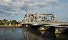
- Point Street Bridge
- Fox Point Hurricane Barrier
- Providence River Bridge (I-195)
- Providence River Pedestrian and Bicycle Bridge[4]
See also
- Green Jacket Shoal
- List of rivers in Rhode Island
- Warren River
- Maps from the United States Geological Survey
References
- "Providence River Dredging Project: Breaking the Impasse through Partnering" (PDF). crmc.state.ri.us. Coastal Resources Management Council. Archived from the original (PDF) on 2007-07-04.
- "La Gondola in La Prov: Like Venice, but with fewer pigeons". Motif Magazine. 16 June 2019. Retrieved 6 October 2019.
- Patinkin, Mark (20 August 2014). "Mark Patinkin: A touch of Venice in Providence on a gondola". The Providence Journal. Retrieved 6 October 2019.
- List, Madeline (9 August 2019). "$21.9 million later, pedestrian bridge opens in downtown Providence". The Providence Journal. Retrieved 16 August 2019.
External links
| Wikimedia Commons has media related to Providence River. |
- Providence.edu Providence River Dredging Project Answer Sheet
| Islands | 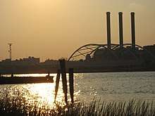 | |
|---|---|---|
| Major rivers | ||
| Cities & towns | ||
| Bridges | ||
| Authority control |
|
|---|