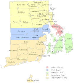
List of municipalities in Rhode Island
Rhode Island is a state located in the Northeastern United States. According to the 2010 United States Census, Rhode Island is the 8th least populous state with 1,052,567 inhabitants and the smallest by land area spanning 1,033.81 square miles (2,677.6 km2) of land.[1] It is divided into 39 incorporated municipalities, including 8 cities and 31 towns, grouped into 5 historical counties that have no municipal functions as the state has no county level of government.[2][3] The entire area of the state is governed by town administrations except for areas within the boundaries of cities.[3] While some communities within towns and cities are census-designated places, there are no unincorporated areas in the state.
.svg.png)
Municipalities in Rhode Island can incorporate as a town or city by a special act of the state legislature and there is no minimum population requirement.[3] Eight municipalities were re-incorporated as cities operating under a charter, while the other 31 remain as towns which perform similar services.[3] Since Rhode Island has no county level of government, cities and towns provide services commonly performed by county governments in other states.[3] The state's cities and towns may adopt one of four forms of government: council–manager, mayor–council, town council–town meeting, or administrator–council.[4] The primary difference between these forms of government is how the chief executive is selected.[4] The Council–manager system involves an elected council who exercise overall control of the local government and a chief executive termed city or town manager who is generally appointed by and responsible to the council for the administration of local policies.[5] Council–manager systems may elect a mayor but they have no formal administrative functions with the potential exception of a degree of veto power.[5] Mayor–council systems have a similarly elected council however the mayor is elected and yields administrative power. In the town council–town meeting system, there is no full-time chief executive.[4] There are no towns or cities in Rhode Island that use the administrator–council form of government.
The largest municipality by population in Rhode Island is the state capital of Providence, with 178,042 residents. The smallest municipality by population is New Shoreham on Block Island, with 1,051 year-round residents.[1] The largest municipality by land area is Coventry which spans 59.05 sq mi (152.9 km2), while Central Falls is the smallest at 1.20 sq mi (3.1 km2).[1] Rhode Island and Hawaii are the only two states in which all of the incorporated municipalities have a population greater than 1,000 people.[1]
Cities and towns
![]()
| Name | Type[1] | County[1] | Year established [6] |
Year incorporated [lower-alpha 1][6][7] |
Form of government[6] | Population (2010)[1] |
Population (2000)[1] |
Change | Land area (2010)[1] |
Population density | |
|---|---|---|---|---|---|---|---|---|---|---|---|
| sq mi | km2 | ||||||||||
| Barrington | Town | Bristol | 1653 | 1770 | Council–manager | 16,310 | 16,819 | −3.0% | 8.22 | 21.3 | 1,984.2/sq mi (766.1/km2) |
| Bristol | Town | Bristol | 1680 | 1746 | Council–manager | 22,954 | 22,469 | +2.2% | 9.82 | 25.4 | 2,337.5/sq mi (902.5/km2) |
| Burrillville | Town | Providence | 1730 | 1806 | Council–manager | 15,955 | 15,796 | +1.0% | 55.03 | 142.5 | 289.9/sq mi (111.9/km2) |
| Central Falls | City | Providence | 1730 | 1895 | Mayor–council | 19,376 | 18,928 | +2.4% | 1.20 | 3.1 | 16,146.7/sq mi (6,234.3/km2) |
| Charlestown | Town | Washington | 1669 | 1738 | Council–manager | 7,827 | 7,859 | −0.4% | 36.45 | 94.4 | 214.7/sq mi (82.9/km2) |
| Coventry | Town | Kent | 1639 | 1743[lower-alpha 2] | Council–manager | 35,014 | 33,668 | +4.0% | 59.05 | 152.9 | 593.0/sq mi (228.9/km2) |
| Cranston | City | Providence | 1754 | 1910 | Mayor–council | 80,387 | 79,269 | +1.4% | 28.34 | 73.4 | 2,836.5/sq mi (1,095.2/km2) |
| Cumberland | Town | Providence | 1746 | 1746 | Mayor–council | 33,506 | 31,840 | +5.2% | 26.45 | 68.5 | 1,266.8/sq mi (489.1/km2) |
| East Greenwich | Town | Kent | 1677 | 1677[lower-alpha 3] | Council–manager | 13,146 | 12,948 | +1.5% | 16.39 | 42.4 | 802.1/sq mi (309.7/km2) |
| East Providence | City | Providence | 1812 | 1958 | Mayor–council | 47,037 | 48,688 | −3.4% | 13.24 | 34.3 | 3,552.6/sq mi (1,371.7/km2) |
| Exeter | Town | Washington | 1641 | 1641[lower-alpha 4] | Town meeting | 6,425 | 6,045 | +6.3% | 57.47 | 148.8 | 111.8/sq mi (43.2/km2) |
| Foster | Town | Providence | 1636 | 1781 | Town meeting | 4,606 | 4,274 | +7.8% | 50.80 | 131.6 | 90.7/sq mi (35.0/km2) |
| Glocester | Town | Providence | 1639 | 1730–1731 | Town meeting | 9,746 | 9,948 | −2.0% | 54.18 | 140.3 | 179.9/sq mi (69.5/km2) |
| Hopkinton | Town | Washington | 1639 | 1757 | Town meeting | 8,188 | 7,836 | +4.5% | 42.95 | 111.2 | 190.6/sq mi (73.6/km2) |
| Jamestown | Town | Newport | 1639 | 1678 | Council–manager | 5,405 | 5,622 | −3.9% | 9.45 | 24.5 | 572.0/sq mi (220.8/km2) |
| Johnston | Town | Providence | 1636 | 1759 | Mayor–council | 28,769 | 28,195 | +2.0% | 23.43 | 60.7 | 1,227.9/sq mi (474.1/km2) |
| Lincoln | Town | Providence | 1650 | 1871 | Council–manager | 21,105 | 20,898 | +1.0% | 18.12 | 46.9 | 1,164.7/sq mi (449.7/km2) |
| Little Compton | Town | Newport | 1682 | 1746 | Town meeting | 3,492 | 3,593 | −2.8% | 20.52 | 53.1 | 170.2/sq mi (65.7/km2) |
| Middletown | Town | Newport | 1639 | 1743 | Council–manager | 16,150 | 17,334 | −6.8% | 12.72 | 32.9 | 1,269.7/sq mi (490.2/km2) |
| Narragansett | Town | Washington | 1888 | 1901 | Council–manager | 15,868 | 16,361 | −3.0% | 13.89 | 36.0 | 1,142.4/sq mi (441.1/km2) |
| Newport | City | Newport | 1639 | 1784[lower-alpha 5] | Council–manager | 24,672 | 26,475 | −6.8% | 7.67 | 19.9 | 3,216.7/sq mi (1,242.0/km2) |
| New Shoreham | Town | Washington | 1664 | 1672 | Council–manager | 1,051 | 1,010 | +4.1% | 9.08 | 23.5 | 115.7/sq mi (44.7/km2) |
| North Kingstown | Town | Washington | 1641 | 1674 | Council–manager | 26,486 | 26,326 | +0.6% | 43.14 | 111.7 | 614.0/sq mi (237.0/km2) |
| North Providence | Town | Providence | 1636 | 1765 | Mayor–council | 32,078 | 32,411 | −1.0% | 5.62 | 14.6 | 5,707.8/sq mi (2,203.8/km2) |
| North Smithfield | Town | Providence | 1730 | 1871 | Council–manager | 11,967 | 10,618 | +12.7% | 23.80 | 61.6 | 502.8/sq mi (194.1/km2) |
| Pawtucket | City | Providence | 1671 | 1954 | Mayor–council | 71,148 | 72,958 | −2.5% | 8.68 | 22.5 | 8,196.8/sq mi (3,164.8/km2) |
| Portsmouth | Town | Newport | 1638 | 1640[lower-alpha 6] | Council–manager | 17,389 | 17,149 | +1.4% | 22.98 | 59.5 | 756.7/sq mi (292.2/km2) |
| Providence | City | Providence | 1636 | 1832 | Mayor–council | 178,042 | 173,618 | +2.5% | 18.40 | 47.7 | 9,676.2/sq mi (3,736.0/km2) |
| Richmond | Town | Washington | 1669 | 1747 | Town meeting | 7,708 | 7,222 | +6.7% | 40.29 | 104.4 | 191.3/sq mi (73.9/km2) |
| Scituate | Town | Providence | 1636 | 1730 | Town meeting | 10,329 | 10,324 | 0.0% | 48.16 | 124.7 | 214.5/sq mi (82.8/km2) |
| Smithfield | Town | Providence | 1636 | 1730 | Council–manager | 21,430 | 20,613 | +4.0% | 26.31 | 68.1 | 814.5/sq mi (314.5/km2) |
| South Kingstown | Town | Washington | 1657 | 1723[lower-alpha 7] | Council–manager | 30,639 | 27,921 | +9.7% | 56.45 | 146.2 | 542.8/sq mi (209.6/km2) |
| Tiverton | Town | Newport | 1694 | 1746 | Town meeting | 15,780 | 15,260 | +3.4% | 29.05 | 75.2 | 543.2/sq mi (209.7/km2) |
| Warren | Town | Bristol | 1620 | 1747 | Council–manager | 10,611 | 11,360 | −6.6% | 6.12 | 15.9 | 1,733.8/sq mi (669.4/km2) |
| Warwick | City | Kent | 1642 | 1931 | Mayor–council | 82,672 | 85,808 | −3.7% | 35.04 | 90.8 | 2,359.4/sq mi (911.0/km2) |
| Westerly | Town | Washington | 1661 | 1669 | Council–manager | 22,787 | 22,966 | −0.8% | 29.52 | 76.5 | 771.9/sq mi (298.0/km2) |
| West Greenwich | Town | Kent | 1639 | 1741 | Town meeting | 6,135 | 5,085 | +20.6% | 50.26 | 130.2 | 122.1/sq mi (47.1/km2) |
| West Warwick | Town | Kent | 1648 | 1913 | Council–manager | 29,191 | 29,581 | −1.3% | 7.79 | 20.2 | 3,747.2/sq mi (1,446.8/km2) |
| Woonsocket | City | Providence | 1867 | 1888 | Mayor–council | 41,186 | 43,224 | −4.7% | 7.74 | 20.0 | 5,321.2/sq mi (2,054.5/km2) |
| Total | — | — | — | — | — | 1,052,567 | 1,048,319 | +0.4% | 1,033.82 | 2,677.6 | 1,018.13/sq mi (393.10/km2) |
Gallery
- Largest municipalities in Rhode Island by population
 Downtown Providence, the capital and most populous city in Rhode Island
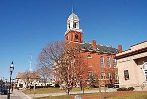 City Hall of Warwick, the second most populous city in Rhode Island
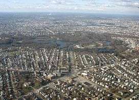 Aerial view of Cranston, the third most populous city in Rhode Island
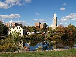 Downtown Pawtucket, the fourth most populous city in Rhode Island
Notes
- Refers to the date of incorporation of the current municipal status.
- There is a discrepancy in dates from the two provided sources, with the Snow (1865) source listing the incorporation date as 1741.
- This date is only found in the Snow (1865) source and is absent in the Government of Rhode Island source.
- There is a discrepancy in dates from the two provided sources, with the Snow (1865) source listing the incorporation date as 1742–1743.
- This date is only found in the Government of Rhode Island source and is absent in the Snow (1865) source.
- This date is only found in the Snow (1865) source and is absent in the Government of Rhode Island source.
- There is a discrepancy in dates from the two provided sources, with the Snow (1865) source listing the incorporation date as 1722.
References
- "GCT-PH1 – Population, Housing Units, Area, and Density: 2010 – State — Place and (in selected states) County Subdivision". 2010 United States Census. United States Census Bureau. Retrieved June 17, 2016.
- "Rhode Island: 2010 Population and Housing Unit Counts 2010 Census of Population and Housing" (PDF). 2010 United States Census. United States Census Bureau. September 2012. p. 18. Retrieved June 17, 2016.
- "A Brief Summary of Municipal Incorporation Procedures by State" (PDF). Senate of Georgia. Carl Vinson Institute of Government, University of Georgia. Retrieved March 16, 2017.
- "Municipal Charters in Rhode Island" (PDF). Rhode Island Department of Revenue: Division of Municipal Finance. Retrieved April 29, 2017.
- "Council–Manager Form of Government". Town of Coventry, Rhode Island. Archived from the original on November 19, 2016. Retrieved April 29, 2017.
- "Rhode Island Cities & Towns". Rhode Island Government. Rhode Island Interactive. Retrieved March 5, 2017.
- Snow, Edwin M. (1865). Report Upon the Census of Rhode Island, 1865: With the Statistics of the Population, Agriculture, Fisheries and Manufactures of the State. University of Michigan. Rhode Island Census Board. p. xxvii.
External links
Providence (capital) | ||
| Topics |
| |
| Society |
| |
| Regions | ||
| Cities | ||
| Towns |
| |