Wiang Chiang Rung District
Wiang Chiang Rung (Thai: เวียงเชียงรุ้ง, pronounced [wīa̯ŋ t͡ɕʰīa̯ŋ rúŋ]) is a district (amphoe) of Chiang Rai Province, northern Thailand.
Wiang Chiang Rung เวียงเชียงรุ้ง | |
|---|---|
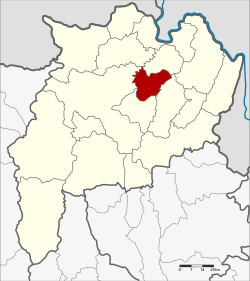 District location in Chiang Rai Province | |
| Coordinates: 20°0′47″N 100°3′25″E | |
| Country | Thailand |
| Province | Chiang Rai |
| Seat | Thung Ko |
| Area | |
| • Total | 263.3 km2 (101.7 sq mi) |
| Population (2005) | |
| • Total | 26,531 |
| • Density | 100.8/km2 (261/sq mi) |
| Time zone | UTC+7 (ICT) |
| Postal code | 57210 |
| Geocode | 5717 |
Geography
Neighboring districts are (from the west clockwise) Mueang Chiang Rai, Doi Luang, Chiang Khong, Phaya Mengrai and Wiang Chai of Chiang Rai Province.
History
The minor district (king amphoe) was established on 1 April 1995, when it was split off from Wiang Chai District .[1] At first named Chiang Rung, it was renamed Wiang Chiang Rung on 1 March 1996.[2]
On 15 May 2007, all 81 minor districts were upgraded to full districts.[3] With publication in the Royal Gazette on 24 August the upgrade became official.[4]
Administration
The district is divided into three sub-districts (tambons), which are further subdivided into 43 villages (mubans). Ban Lao is a township (thesaban tambon) which covers parts of tambons Thung Ko and Dong Maha Wan. There are a further three tambon administrative organizations (TAO).
| No. | Name | Thai name | Villages | Pop. | |
|---|---|---|---|---|---|
| 1. | Thung Ko | ทุ่งก่อ | 15 | 10,227 | |
| 2. | Dong Maha Wan | ดงมหาวัน | 12 | 6,435 | |
| 3. | Pa Sang | ป่าซาง | 16 | 9,869 |
References
- ประกาศกระทรวงมหาดไทย เรื่อง แบ่งเขตท้องที่อำเภอเวียงชัย จังหวัดเชียงราย ตั้งเป็นกิ่งอำเภอเชียงรุ้ง (PDF). Royal Gazette (in Thai). 112 (Special 9 ง): 67. March 22, 1995.
- ประกาศกระทรวงมหาดไทย เรื่อง เปลี่ยนแปลงชื่อกิ่งอำเภอเชียงรุ้ง อำเภอเวียงชัย จังหวัดเชียงราย (PDF). Royal Gazette (in Thai). 113 (19 ง): 5. March 5, 1995.
- แถลงผลการประชุม ครม. ประจำวันที่ 15 พ.ค. 2550 (in Thai). Manager Online.
- พระราชกฤษฎีกาตั้งอำเภอฆ้องชัย...และอำเภอเหล่าเสือโก้ก พ.ศ. ๒๕๕๐ (PDF). Royal Gazette (in Thai). 124 (46 ก): 14–21. August 24, 2007.
External links

- amphoe.com
Chiang Rai | ||
|---|---|---|
| Main article |  | |
| Capital city | ||
| Districts (amphoe) |
| |
| Related topics |
| |