Chiang Khong District
Chiang Khong (Thai: เชียงของ, pronounced [t͡ɕʰīa̯ŋ kʰɔ̌ːŋ]) is a district (amphoe) in the northeastern part of Chiang Rai Province, northern Thailand.
Chiang Khong เชียงของ | |
|---|---|
.jpg) Mekong River, Chiang Khong | |
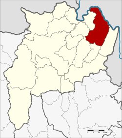 District location in Chiang Rai Province | |
| Coordinates: 20°15′36″N 100°24′24″E | |
| Country | Thailand |
| Province | Chiang Rai |
| Seat | Wiang |
| Subdistricts | 7 |
| Mubans | 102 |
| Area | |
| • Total | 836.9 km2 (323.1 sq mi) |
| Population (2015) | |
| • Total | 64,197 |
| • Density | 76.1/km2 (197/sq mi) |
| Time zone | UTC+7 (ICT) |
| Postal code | 57140 |
| Geocode | 5703 |
Geography
The Phi Pan Nam mountains and their wide intermontane basins dominate the landscape of the district. The 1,328 m high Doi Luang Pae Mueang massif (ดอยหลวงแปเมือง) rises west of Chiang Khong town. The Mekong River flows at the northern end of the district, partially forming the boundary with Laos. Another important river is the Ing, a tributary of the Mekong.
Neighboring districts are (from the southeast clockwise): Wiang Kaen, Khun Tan, Phaya Meng Rai, Wiang Chiang Rung, Doi Luang and Chiang Saen of Chiang Rai Province. To the east is Bokeo Province of Laos.
Administration
Central administration
Chiang Khong is divided into seven subdistricts (tambons), which are further subdivided into 102 administrative villages (mubans).
| No. | Name | Thai | Villages | Pop.[1] |
|---|---|---|---|---|
| 1. | Wiang | เวียง | 14 | 13,391 |
| 2. | Sathan | สถาน | 16 | 9,428 |
| 3. | Khrueng | ครึ่ง | 11 | 6,571 |
| 4. | Bun Rueang | บุญเรือง | 10 | 6,262 |
| 5. | Huai So | ห้วยซ้อ | 23 | 12,563 |
| 8. | Si Don Chai | ศรีดอนชัย | 18 | 8,927 |
| 10. | Rim Khong | ริมโขง | 10 | 7,055 |
Missing numbers belonged to the tambons which now form Wiang Kaen District.
Local administration
There are seven subdistrict municipalities (thesaban tambons) in the district:
- Bun Rueang (Thai: เทศบาลตำบลบุญเรือง) consisting of subdistrict Bun Rueang.
- Wiang Chiang Khong (Thai: เทศบาลตำบลเวียงเชียงของ) consisting of parts of subdistrict Wiang.
- Wiang (Thai: เทศบาลตำบลเวียง) consisting of parts of subdistrict Wiang.
- Khrueng (Thai: เทศบาลตำบลครึ่ง) consisting of subdistrict Khrueng.
- Huai So (Thai: เทศบาลตำบลห้วยซ้อ) consisting of subdistrict Huai So.
- Sathan (Thai: เทศบาลตำบลสถาน) consisting of subdistrict Sathan.
- Si Don Chai (Thai: เทศบาลตำบลศรีดอนชัย) consisting of subdistrict Si Don Chai.
There is one subdistrict administrative organization (SAO) in the district:
- Rim Khong (Thai: องค์การบริหารส่วนตำบลริมโขง) consisting of subdistrict Rim Khong.
References
- "Population statistics 2015" (in Thai). Department of Provincial Administration. Retrieved 9 June 2016.
External links
| Wikimedia Commons has media related to Chiang Khong District. |

- amphoe.com