Bogra
Bogra, officially known as Bogura,[1] is a major city located in the Bogra District, Rajshahi Division, Bangladesh. It is major commercial hub. The Bogra bridge connects the Rajshahi Division and Rangpur Division and also the largest City in Rajshahi.This city is also known as the capital of North Bengal (উত্তরবঙ্গ) of Bangladesh. Shatmatha is the heart of this city.
Bogra বগুড়া Bogura | |
|---|---|
Municipality | |
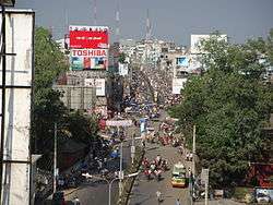 Bogra Sathmatha (Heart of Bogra) | |
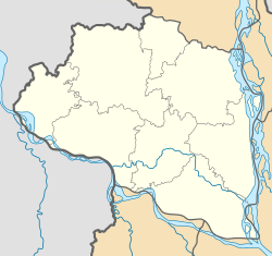 Bogra Location in Rajshahi Division  Bogra Location in Bangladesh | |
| Coordinates: 24°51′N 89°22′E | |
| Country | Bangladesh |
| Division | Rajshahi Division |
| District | Bogra District |
| Pundravardhana | 1280 BC |
| Area | |
| • Total | 69.56 km2 (26.86 sq mi) |
| Elevation | 20 m (70 ft) |
| Population (2017) | |
| • Total | 540,000 |
| Time zone | UTC+6 (BST) |
| Postal code | 5800 |
| Calling code | 051 |
| Website | www |
Bogra is named after Nasiruddin Bughra Khan, the Governor of Bengal from 1279 to 1282[2] and the son of Delhi Sultan Ghiyasuddin Balban.
The city is approximately 69.56 km2 (26.86 sq mi) and is divided into 21 wards. Bogra has a population of around 540,000 people. Since it is the oldest city in Bengal, Bogra is famous for its many ancient Buddhist stupas, Hindu temples, and ancient palaces of Buddhist kings and Muslim sultans. The cuisine of Bogra is famous for the diversity of its desserts and its famous Bogurar doi named after this city.
The city has produced notable personalities including Prime Minister Muhammad Ali Bogra of Pakistan, President Ziaur Rahman of Bangladesh, All were born or have lived in the city. The current mayor of the municipality is Advocate Mahbubur Rahman (2004 To Till) from BNP .
History
Bogra is considered the oldest city of Bengal, dating to the reign of the Great Emperor Ashoka, who ruled India from 268 to 232 BCE. When Ashoka conquered the Bengal (Bongo) region, he founded Bogra and called it Pundra Bardhan. This is supported by the discovery in October 2008 of an ancient engraved stone believed to be produced in the Gupta era near Sura Masjid at Ghoraghat Upazila in Dinajpur.
During the Bangladesh War of Independence, the area witnessed the Battle of Bogra, a fierce conflict between the guerrilla units of the Bangladesh Forces under Sector 7 and the Pakistan Army.
Geography

First formed in 1821, the administrative district of Bogra contains an area of 1,359 sq mi (3,520 km2).
The principal rivers in the district are formed by the different channels of the Brahmaputra. The rivers have local names such as the Konai, the Daokoba, and the Jamuna. The latter forms a portion of the eastern boundary of the district. The Brahmaputra and its channels, together with three minor streams, the Bangali, Karatoya and Atrai, drive the thriving commercial activities in the area.
In 1911 the Karatoya (which flows from north to south), divided the district into two portions, the eastern tract with rich alluvial soil, subject to fertilizing inundations, yielded heavy crops of coarse rice, oil seeds, and jute, while the soil of the higher western portion of the district allowed for growing rice.[3]
Climate
The city enjoys a tropical climate, with two main seasons: winter and summer. Bogra experiences more rainfall during the summer.
| Climate data for Bogra | |||||||||||||
|---|---|---|---|---|---|---|---|---|---|---|---|---|---|
| Month | Jan | Feb | Mar | Apr | May | Jun | Jul | Aug | Sep | Oct | Nov | Dec | Year |
| Average high °C (°F) | 25.0 (77.0) |
28.0 (82.4) |
32.6 (90.7) |
35.1 (95.2) |
33.5 (92.3) |
32.2 (90.0) |
31.4 (88.5) |
31.4 (88.5) |
31.5 (88.7) |
31.0 (87.8) |
28.9 (84.0) |
26.0 (78.8) |
30.6 (87.0) |
| Average low °C (°F) | 11.7 (53.1) |
13.5 (56.3) |
17.9 (64.2) |
22.5 (72.5) |
24.1 (75.4) |
25.6 (78.1) |
26.1 (79.0) |
26.1 (79.0) |
25.6 (78.1) |
23.2 (73.8) |
17.6 (63.7) |
13.1 (55.6) |
20.6 (69.1) |
| Average precipitation mm (inches) | 9 (0.4) |
13 (0.5) |
21 (0.8) |
61 (2.4) |
210 (8.3) |
326 (12.8) |
397 (15.6) |
302 (11.9) |
257 (10.1) |
145 (5.7) |
15 (0.6) |
6 (0.2) |
1,762 (69.4) |
| Source: Climate-data.org | |||||||||||||
Economy
Since the 2009 adoption of new urban planning, there has been a significant development in the infrastructure of Bogra. This includes the restructuring and widening of roads, improvement of telecommunications infrastructure, and the installation of underground gas connections.
Additionally, red chili production in Bogra is a major industry, with companies such as Square, Acme, and BD Food collecting red chili from twelve centers within Bogra.[4]
Often called the "Town of Banks", Bogra is the location of numerous online banking facilities, credit card, debit card, and remittance companies. Banking in Bogra has significantly expanded with the presence of government banks such as the Bangladesh Bank (Central Bank), Sonali Bank, Rupali Bank, Janata Bank, Rajshahi Krishi Unnayan Bank, Bangladesh Development Bank Ltd., Uttara Bank Ltd, and Agrani Bank, as well as a number of private and specialized banks, including Pubali Bank, National Bank, IFIC bank Ltd., Citi Bank Ltd., and others.

Bogra is also home to an increasing number of IT, software, technology, and computer services companies.[5] One of the milestones of its tech sector occurred in 2008 when the French Grameen Group and Groupe Danone entered into a joint venture with a local company to establish an organization named Grameen Danone.[6]
.jpg)
Statistically, Bogra's workforce is still dominated by jobs in the agriculture sector (29.95%) and agricultural manufacturing (12.53%). They are followed by general commerce (18.11%), customer service (15.62%), transportation (6.66%), wage labor (2.2%), and other industries (14.93%).[7]
Transportation
Bogra has several railway stations and bus terminals.
Tourism
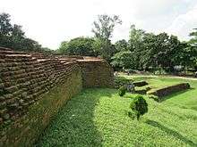
Bogra is home to Mahasthangarh, the earliest known urban archaeological site in Bangladesh, as well as the village of Mahasthan in Shibganj thana of Bogra District. This site contains the remains of Pundranagara (or Paundravardhanapura), an ancient city in the territory of Pundravardhana.[8][9][10] This place is considered sacred to Buddhists, Muslims, and Hindus alike.[11] Pilgrims and visitors tour the area all year round.
The Behular Bashor Ghor is a popular tourist attraction in the city and is close to other popular spots and monuments such as the Mahasthangar, Nawab Palace (called Neelkuthi during the British period), Kherua Mosque (Sherpur Upazila), Bara Mosque, Mazar of Shah Sultan Balkhi, Mazar of Panchpir, Gokul Medh, Palace of Parshuram, Basu Bihara, Palli Unnayan Academy, Saudia City Park, Bhimer Jangle, Museum of Nawab Bari Palace, Wonderland Shishupark (a children's park), Shanewaz Shishubagan, Woodburn Park, Dreshtinandan Park, Bijayangan (the War of Liberation museum), and the Jaina Temple.
Notable residents
- Akhteruzzaman Elias (1943–1997), Novelist and short story writer
- Gaziul Haque (1929–2009), Language movement veteran
- Khademul Bashar (1935–1976), Bir Uttam, Sector Commander in the Liberation War and former Chief of the Bangladesh Air Force
- Muhammad Ali Bogra (1909–1963), Notable diplomat, former Prime Minister of Pakistan (1953–1955)
- Monoj Dasgupta (1949-1997) Poet, writer, organiser and politician.
- Mushfiqur Rahim Cricketer of the Bangladesh cricket team.
- Ziaur Rahman Freedom Fighter, Social Worker, Former President of Bangladesh (21 April 1977 - 30 May 1981)
- Humayun Ahmed The great fiction writer.
- Abdus Samad Mondal The great freedom Fighter writer.
- Shafiul Islam Cricketer on the Bangladesh cricket team.
- Apu Biswas Bangladeshi Film Actress.
- Tarun Majumdar Bengali Indian Film Director
See also
- Bogra Sadar Upazila, a sub-district (upzalia) of Bogra.
Notes
- "Bangladesh changes English spellings of five districts". Bdnews24.com. Dhaka. 2 April 2018. Retrieved 2 April 2018.
- জেলার পটভূমি [District Background]. bogra.gov.bd. Archived from the original on 5 December 2016. Retrieved 5 February 2017.
- Chisholm 1911, p. 121.
- "Turnover goes up to Tk 100cr from Tk 5cr in just 5 years". The Daly Star. Retrieved 6 December 2009.
- Bogua Database, retrieved 7 December 2009, Bogra.info
- "French minister backs social business". The Daily Star. Retrieved 6 December 2009.
- Chawdhury, Shagata (2012). "Bogra Sadar Upazila". In Islam, Sirajul; Jamal, Ahmed A. (eds.). Banglapedia: National Encyclopedia of Bangladesh (Second ed.). Asiatic Society of Bangladesh.
- Hossain, Md. Mosharraf, Mahasthan: Anecdote to History, 2006, Preface, Dibyaprakash, 38/2 ka Bangla Bazar, Dhaka, ISBN 9844832454
- Brochure: Mahasthan – the earliest city-site of Bangladesh, published by the Department of Archaeology, Ministry of Cultural Affairs, Government of the People’s Republic of Bangladesh, 2003
- Majumdar, Dr. R.C., History of Ancient Bengal, First published 1971, Reprint 2005, p. 10, Tulshi Prakashani, Kolkata, ISBN 81-89118-01-3.
- Khan, Ayub (2012). "Goku Medh". In Islam, Sirajul; Jamal, Ahmed A. (eds.). Banglapedia: National Encyclopedia of Bangladesh (Second ed.). Asiatic Society of Bangladesh.
References

External links
| Wikimedia Commons has media related to Bogura. |

- Population and Housing Census 2011 - Volume 3: Urban Area Report (PDF), Bangladesh Bureau of Statistics, August 2014