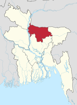
Rangpur Division
Rangpur Division (Bengali: রংপুর বিভাগ) is one the Divisions in Bangladesh. It was formed on 25 January 2010,[1] as Bangladesh's 7th division. Before that, it was under Rajshahi Division. The Rangpur division consists of eight districts. There are 58 Upazilas or subdistricts under these eight districts. Rangpur is the northernmost division of Bangladesh and has a population of 15,665,000 in the 2011 Census.
Rangpur Division রংপুর বিভাগ | |
|---|---|
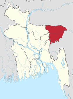
 Map of Rangpur Division | |
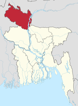
 Districts of Rangpur Division | |
| Coordinates: 25°50′N 89°00′E | |
| Country | |
| Established | 1 July 2010 |
| Capital | Rangpur City |
| Area | |
| • Total | 16,184.99 km2 (6,249.06 sq mi) |
| Population (2011 census) | |
| • Total | 15,787,758 |
| • Density | 980/km2 (2,500/sq mi) |
| Demonym(s) | Rangpuri, Rongpuri |
| Time zone | UTC+6 (BST) |
| ISO 3166 code | BD-F |
| Notable cricket teams | Rangpur Riders, Rangpur Division |
| Website | www |
The major cities of this new division are Rangpur, Saidpur and Dinajpur. Rangpur has well-known educational institutions, such as Carmichael College, Hajee Mohammad Danesh Science and Technology University, Rangpur Medical College, Rangpur Cadet College, Begum Rokeya University and Bangladesh Army University of Science & Technology, Saidpur.
Mansingh, commander of Emperor Akbar, conquered part of Rangpur in 1575. Rangpur came completely under the Mughal empire in 1686. Mughalbasa and Mughalhat of Kurigram district still bear marks of the Mughal rule in the region. During the Mughal rule part of Rangpur was under the sarkar of Ghoraghat, and part under the sarkar of Pinjarah.[2] Rangapur Ghoraghat has been mentioned in the Riyaz-us-Salatin. During the early period of the company rule Fakir-Sannyasi Rebellion and peasant rebellion were held in Rangpur.
Administrative Divisions
Rangpur Division was formed by taking 8 northern districts os Rajshahi Division. Now it has 8 Districts, 58 Upazilas, 1 City Corporation, 21 Pourasavas and 536 Union councils.
| District Name | Capital | Area (Sq km.) | Population (2011) |
|---|---|---|---|
| Rangpur District | Rangpur | 2400.56 | 2996336 |
| Dinajpur District | Dinajpur | 3444.30 | 2990128 |
| Kurigram District | Kurigram | 2245.04 | 2069273 |
| Nilphamari District | Nilphamari | 1643.70 | 1907497 |
| Gaibandha District | Gaibandha | 2179.27 | 2430627 |
| Thakurgaon District | Thakurgaon | 1781.74 | 1390042 |
| Panchagarh District | Panchagarh | 1404.63 | 987644 |
| Lalmonirhat District | Lalmonirhat | 1247.371 | 1256099 |
| Total | 16184.99 | 15787758 |
Demographics
Accoding to 2011 cencus, the total population of Rangpur Division is 15,787,758 and population density is 980/Sq km. 51.18% of total population is male, and 48.82% is female. Notable indigenious groups are Saontal, Munda, Oraon, Rajbanshi and Koch. Most of the people of Rangpur Division are belong to Muslims and Hindus, whereas a small number of adherents of Christianity and other religions are also seen.[3]
Communication
Rangpur has a good road, rail and air communication with capital as well as other parts of the country. The N5 (National Highway 5) links the division with capital. There are total 21 express train which connects different districts of the division with capital and other part of the country. There are also three Domestic airports, among them Saidpur Airport is the major one.
See also
References
| Wikivoyage has a travel guide for Rangpur Division. |
- Rajib Mondal (2012). "Rangpur Division". In Sirajul Islam and Ahmed A. Jamal (ed.). Banglapedia: National Encyclopedia of Bangladesh (Second ed.). Asiatic Society of Bangladesh.
- Nasrin Akhter (2012). "Sarkar". In Sirajul Islam and Ahmed A. Jamal (ed.). Banglapedia: National Encyclopedia of Bangladesh (Second ed.). Asiatic Society of Bangladesh.
- "Rangpur Division". Banglapedia. 27 October 2015.
Places adjacent to Rangpur Division | ||||||||||
|---|---|---|---|---|---|---|---|---|---|---|
| ||||||||||