Sarail Upazila
Sarail (Bengali: সরাইল, romanized: Shorail) is an Upazila of Brahmanbaria District[1] in Chittagong Division, Bangladesh.
Sarail সরাইল | |
|---|---|
Upazila | |
 Sarail Location in Bangladesh | |
| Coordinates: 24°7.1′N 91°7.5′E | |
| Country | |
| Division | Chittagong Division |
| District | Brahmanbaria District |
| Area | |
| • Total | 239.52 km2 (92.48 sq mi) |
| Population (2011) | |
| • Total | 315.208 |
| Time zone | UTC+6 (BST) |
| Postal code | 3430 |
| Website | Official Website of Sarail |
History


The leader of the Baro-Bhuiyan zamindars, Isa Khan, had his first and temporary capital situated in Sarail.[2] During the Mughal era, Sarail was a mahallah (district) of the Sylhet Sarkar.[3]
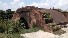
During the dewani of Shahbaz Khan in 1650, the Hatirpul was constructed. It was a bridge built over the canal mainly for elephant pass. The Mughal dewans used to communicate by the elephant in this road and also took rest near this bridge. In 1662, the Arifil Mosque was constructed by Shah Arif. There are unknown tombs located near the mosque, supposedly belonging to the wives of Isa Khan.
During the Bangladesh Liberation War of 1971, the Pakistani Army killed about 70 innocent people in the Bitghar area. On 5 May, the freedom fighters raided the Pakistani Army's camp in the Shahbazpur area and killed 9 Pakistani soldiers; one freedom fighter was killed during this raid. A number of Pakistani Army officers and the chairman of the Sarail Peace Committee were also killed. The freedom fighters set up a mine bomb north of Kalikaccha Bazar. This exploded and destroyed two military vehicles. Three mass graves remain in Sarail. Memorial monuments were established in the upazila's Bitghar area, the Annada Government High School, the Sarail Degree College and also a monument dedicated to the martyr Sheikh Mesbahuddin Saraili.
In 1990, Sarail was made an upazila of Bangladesh.[1]
Geography
Sarail is located at 24.118333°N 91.125°E. It has 43,854 households and a total area of 227.22 km².[1]
Demographics
According to the 1991 Bangladesh census, Sarail had a population of 254,481. Males constituted 50.32% of the population, and females 49.68%. The population aged 18 or over was 120,249. Sarail had an average literacy rate of 22.6% (7+ years), against the national average of 32.4%.[4]
Administration
Chairman: Rafiq ad-Din Thakur Sarail has 9 Unions/Wards, 76 Mauzas/Mahallas, and 146 villages. The Unions are:[1]
- Aruail
- Chunta
- Kalikachchha
- Noagaon
- Pak Shimul
- Sarail
- Shahbazpur
- Shahjadapur
- Uttar Panisar
See also
- Upazilas of Bangladesh
- Districts of Bangladesh
- Divisions of Bangladesh
References
- Md. Azad Uddin Thakur (2012). "Sarail Upazila". In Islam, Sirajul; Miah, Sajahan; Khanam, Mahfuza; Ahmed, Sabbir (eds.). Banglapedia: the National Encyclopedia of Bangladesh (Online ed.). Dhaka, Bangladesh: Banglapedia Trust, Asiatic Society of Bangladesh. ISBN 984-32-0576-6. OCLC 52727562. Retrieved 27 June 2020.
- AA Sheikh Md Asrarul Hoque Chisti (2012). "Isa Khan". In Islam, Sirajul; Miah, Sajahan; Khanam, Mahfuza; Ahmed, Sabbir (eds.). Banglapedia: the National Encyclopedia of Bangladesh (Online ed.). Dhaka, Bangladesh: Banglapedia Trust, Asiatic Society of Bangladesh. ISBN 984-32-0576-6. OCLC 52727562. Retrieved 27 June 2020.
- Nath, Pratyay (28 Jun 2019). Climate of Conquest: War, Environment, and Empire in Mughal North India. Oxford University Press.
- "Population Census Wing, BBS". Archived from the original on 2005-03-27. Retrieved November 10, 2006.
Capital: Brahmanbaria | ||
| Upazilas | ||
| Constituencies | ||
| Attractions and sites | ||
| History | ||
| Inhabited areas | ||
| Rivers | ||
| Educational institutions | ||
| Organisations | ||
| Transport | ||
Capital: Chattogram | ||
| Bandarban District |  | |
| Brahmanbaria District | ||
| Chandpur District | ||
| Chattogram District | ||
| Cumilla District |
| |
| Cox's Bazar District | ||
| Feni District | ||
| Khagrachari District |
| |
| Lakshmipur District | ||
| Noakhali District | ||
| Rangamati District | ||