Thakurgaon District
Thakurgaon (Bengali: ঠাকুরগাঁও জেলা, Thakurgaon Jela also Thakurgaon Zila) is a district in the north-western side of Bangladesh. It is a part of the Rangpur Division and borders India to the west.[2] It was established as a mahakuma in 1860 consisting of 6 thanas named Thakurgaon sadar, Baliadangi, Pirganj, Ranishankail, Haripur and Ruhia. In 1947, it was re-established as a mahakuma including 3 thanas of Jalpaiguri and a thana of kochbihar of India. In 1981, Atoari was included in the new Panchagarh district and the area was shrunk in just 5 thanas. It was then established as a district in 1 February 1984.[3]
Thakurgaon | |
|---|---|
 Location of Thakurgaon District in Bangladesh | |

Expandable map of Thakurgaon District | |
| Coordinates: 25.95°N 88.25°E | |
| Country | |
| Division | Rangpur Division |
| Area | |
| • Total | 1,781.74 km2 (687.93 sq mi) |
| Population (2011 census) | |
| • Total | 1,390,042 |
| • Density | 780/km2 (2,000/sq mi) |
| Time zone | UTC+06:00 (BST) |
| Postal code | 5100 |
| HDI (2018) | 0.614[1] medium · 7th of 21 |
Subdistricts
There are 5 upazilas, 6 thanas, 53 unions, 647 mouzas and 1016 villages in Thakurgaon. The Upazilas in this district are:
There is also another Pirganj upazila under Rangpur district
The Thana in this district are:
- Ruhea Thana
Geography
The area of Thakurgaon is 1,781.74 square kilometres (687.93 sq mi). Thakurgaon is in the north west corner of Bangladesh, it is about 467 km from Dhaka, the capital of Bangladesh. It is surrounded by Dinajpur district on its south, Panchagarh district to the east and India on its west and north sides, it is a part of the Himalayan plain land. Highest average temperature of this district is 33.5° Celsius and lowest average is 10.05° Celsius.[4]
History
During British rule Thakurgaon was a tehsil (a district subdivision). In 1947 at the time of the Partition of India, Thakurgaon Subdivision became part of the newly established Dinajpur District of East Bengal. In 1984 Takurgaon subdivision was split off Dinajpur and became a separate district (i.e. Thakurgaon District). Before 1879 Thakurgaon District was ruled my Maithil Brahmins and Bengali Brahmins like Bikhash Jha, Barun Thakur and Vidhenesh Roy, Until 1947 Thakurgaon district had a just Hindu majority population of 52%.Most people believe thakurgaon district has got its name from Barun Thakur a maithil Brahmin.
Economy
In Bangladesh as a whole agriculture is the basis of the economy, and Thakurgaon has been striving for a long time to be economically productive, agriculture forming a major part of the districts economy. Thakurgaon produces many agricultural products, such as rice, wheat, sugarcane, seasonal vegetables and fruits etc. The sugarcane plantation - TSM (Thakurgaon Sugar Mill)--is part of the BSFIC. These become the main livelihood of the native. Poultry firms are quite productive business in Thakurgaon, there are several cold-stores in the district. Different businesses for producing and repairing agricultural tools have grown up.
However the community's distance from the capital causes difficulties in getting sufficient technical and logistic support and in transporting local products to the national market. It is not easy for the investors to set up their business far away from the center of national trade and commerce.
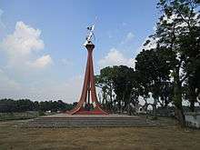
Places of interest[5]

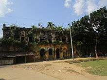
There are various places of interest in the district, these include:
- The Tangon River
- Senua Bridge
- Old Air Port, destroyed during the second world war, situated at Modergonj beside of Arazipaickpara
- Jomidar Mosjid at Shibganj
- Balia Mosjid at Balia Union
- The Fair of Nekmordon
- Ramrai Dighi, it is a pond having 50 acres (200,000 m2) of area. A beautiful tourist spot.
- King's Palace
- The river of Kulic
- KhuniaDhighi Memorial
- Palace of King Tonko Nath
- Gorkoi Heritage
- 500 acre shal garden on the bank of the Tangon River
- Horinmari Amgach (Stand by 3 bigha area )
- Haripur Rajbari
- Gorokkhonath temple
- Ranishankail Jomidar Bari
- Jagdal Rajbari
- Sangah Shahi mosque
- Fatehpur mosque
- Shalbari mosque
Culture
There is a versatile practice of culture in the district; few festivals and cultural events are regularly arranged there. Alpona Sansad arranges Boishakhi Mela in every Bangla new year. Held "Eid Fair" at the occasion of Eid-Ul-Adha & Eid-Ul-Fitre every year at Thakurgaon Boro Matth also. Several drama clubs (Sapla Natto Gosty-Estd.1974, Nischintopur Theater-1983 etc. ) practice and perform regularly and stage original and famous dramas every month. Dhamer Gaan is a unique traditional cultural invention of Thakurgaon people. The existing 10 tribes in this area enjoy their own heritage and cultural practices.
Notable People
- Mirza Fakhrul Islam Alamgir Secretary general of Bangladesh Nationalist Party
- Ramesh Chandra Sen Member of parliament
- Shishir Bhattacharjee famous painter, cartoonist
- Litu Anam famous actor, TV personality
- Musa Ibrahim first Bangladeshi to climb Everest
Gallery
 Shuk_River at Thakurgaon Sadar Upazila
 Playground of Thakurgaon
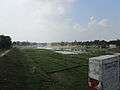 Tangon River from Tangon Bridge
 Kulik River at westside of Ranisankail Upazila
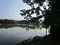 Amai Pond at Haripur Upazila parishad
 A science building of Thakurgaon Govt. College.
References
| Wikimedia Commons has media related to Thakurgaon District. |
| Wikivoyage has a travel guide for Thakurgaon District. |
- "Sub-national HDI - Area Database - Global Data Lab". hdi.globaldatalab.org. Retrieved 18 March 2020.
- Abu Md. Iqbal Rumi Shah (2012). "Thakurgaon District". In Sirajul Islam and Ahmed A. Jamal (ed.). Banglapedia: National Encyclopedia of Bangladesh (Second ed.). Asiatic Society of Bangladesh.
- "History of Thakurgaon". Bangladesh national portal.
- "Thakurgaon at a glance". Bangladesh national portal.
- "Notable places of Thakurgaon". Bangladesh national portal.
