Satkhira District
Satkhira (Bengali: সাতক্ষীরা জেলা, pron: Satkhira) is a district in southwestern Bangladesh and is part of Khulna Division. It lies along the border with West Bengal, India. It is on the bank of the Arpangachhia River. The largest city and headquarter of this district is Satkhira.
Satkhira সাতক্ষীরা | |
|---|---|
 Location of Satkhira District in Bangladesh | |

Expandable map of Satkhira District | |
| Coordinates: 22.35°N 89.08°E | |
| Country | |
| Division | Khulna Division |
| Area | |
| • Total | 3,817.29 km2 (1,473.86 sq mi) |
| Population (2013 census) | |
| • Total | 2,079,884 |
| • Density | 540/km2 (1,400/sq mi) |
| Time zone | UTC+06:00 (BST) |
| Postal code | 9400 |
| HDI (2018) | 0.620[1] medium · 6th of 21 |
Administration
The district consists of two municipalities, seven upazilas, 79 union porishods, 8 thana (police station) and 1436 villages.
The upazilas are:[2]
- Satkhira Sadar Upazila
- Assasuni Upazila
- Debhata Upazila
- Tala Upazila
- Kalaroa Upazila
- Kaliganj Upazila
- Shyamnagar Upazila
The two municipalities are Satkhira and Kalaroa.
Geography
Satkhira District has an area of about 3817.29 km². It is bordered to the north by Jessore District, on the south by the Bay of Bengal, to the east by Khulna District, and to the west by 24 Pargana District of West Bengal, India.
The annual average maximum temperature reaches 35.5 °C (95.9 °F); minimum temperature is 12.5 °C (54.5 °F). The annual rainfall is 1710 mm (67 in).
The main rivers are the Kopotakhi river across Dorgapur union of Assasuni Upazila, Morichap River, Kholpetua River, Betna River, Raimangal River, Hariabhanga river, Ichamati River, Betrabati River and Kalindi-Jamuna River.[5]
Climate
Tropical savanna climates have a monthly mean temperature above 18 °C (64 °F) in every month of the year and typically a pronounced dry season, with the driest month having precipitation less than 60mm (2.36 in) of precipitation. The Köppen Climate Classification subtype for this climate is "Aw" (tropical savanna climate).[6]
| Climate data for Satkhira | |||||||||||||
|---|---|---|---|---|---|---|---|---|---|---|---|---|---|
| Month | Jan | Feb | Mar | Apr | May | Jun | Jul | Aug | Sep | Oct | Nov | Dec | Year |
| Average high °C (°F) | 25 (77) |
28 (82) |
33 (91) |
34 (93) |
34 (93) |
33 (91) |
31 (87) |
31 (87) |
32 (89) |
31 (87) |
29 (84) |
26 (78) |
30 (86) |
| Average low °C (°F) | 12 (53) |
15 (59) |
20 (68) |
24 (75) |
25 (77) |
26 (78) |
26 (78) |
25 (77) |
25 (77) |
23 (73) |
18 (64) |
13 (55) |
21 (69) |
| Average precipitation mm (inches) | 7.6 (0.3) |
23 (0.9) |
30 (1.2) |
71 (2.8) |
140 (5.7) |
290 (11.6) |
350 (13.9) |
330 (12.8) |
270 (10.5) |
140 (5.6) |
25 (1) |
7.6 (0.3) |
1,690 (66.5) |
| Source: Weatherbase[7] | |||||||||||||
Demographics
According to the 2011 Bangladesh census, Satkhira District had a population of 1,985,959. Males constituted 49.49% of the population and females 50.51%. Muslims formed 81.86% of the population, Hindus 17.70%, Christians 0.31% and others 0.12%. Satkhira District had a literacy rate of 52.07% for the population 7 years and above.[8]
Economy
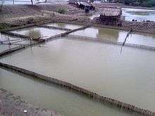
Most of the peoples of southern part of Satkhira depend on pisciculture, locally called gher. Main fruits are aam (mango), jaam (blackberry), kathal (jackfruit), kola (banana), pepe (papaya), lichoo (litchi), naarikel (coconut) and peyara (guava). Farms are 86 dairies, 322 poultry farms, 3046 fisheries, 3650 shrimp farms, 66 hatcheries and one cattle breeding centre. The main exports are shrimp, paddy, jute, wheat, betel leaf, leather and jute goods. Contribute 18.5% of Bangladesh economy. Recently, the wide spread crab fattening is contributing heavily in Satkhira's economy.
Points of interest

Sundarbans is the largest single block of tidal halophytic mangrove forest in the world, is a World Heritage Site, and covers an area of 5747 km².
The region is home to many ancient buildings and temples such as Sultanpur Shahi Mosque (500 years old) and Pir-e-Kamel Kari Hafez Sah-Sufi Jonab Hozrat Maolana Azizur Rahman (Rh) was an Muslim Sufi Saint and local ruler Kalimakhali, assasuni upozila in satkhira (now in Bangladesh). Attractions also include the mangrove forest at Kaligonj Upazila. This forest, named Basjharia Joarar Ban, is popularly known as the forest of BADHA. The Joarar Ban is the cause of friction between Bangladesh and Indian border.
Infrastructure
Land ports

India-Bangladesh (Bhomra land port): 200 yard distant BGP camp from main port. The Bhomra land port is second largest land port in Bangladesh. The Bhomra land customs station was inaugurated in 1996.
Transport
Roads and highways are Satkhira-Khulna, Satkhira-Jessore, Satkhira-Assasuni-Ghola, Satkhira-Kaligonj-Shyamnagar. Satkhira-Kaligonj-Shyamnagar is very bad due to conductor's corruption.
Education
Recently established one medical college, 79 colleges, one primary teachers training institute, 421 high schools, 41 junior high schools, 259 madrassas, 822 government primary schools. Some of the notable educational institutions-
Satkhira Government Girls’ High School
Satkhira Government High School
Satkhira Government Mahila College
Kaliganj Govt. College
Digital Satkhira
In 1994 few young people start computer training center as a business and prepare some talents who later started other computer business and ultimately gives the platform of digital Satkhira. Slowly computer replaces manual type machine in the office, bank and other institutions. School, College starts recruiting Computer teacher to educate new generations. Many more young people start computer business, Manual (letter) printing press switch to offset printing using the computer.
Here is some Pioneer in history: First local daily newspaper published name was "Doinik Satkhira Chitra".
First Computer Sales & Service Centre was "Mitul Computer Services"
First Computer Training Centre was "Cosmos Computer"
First Offset Printing Press was "Zahan Offset Printing Press"
In 1999 first Computer Association of Satkhira established with 30 members. President was MITUL MD MONIRUZZAMAN and General Secretary was NITYANANDA SARKER with Vice President FAROUQE-UL-ISLAM and SAYED IQBAL BABU.
Computer Association of Satkhira regularly organizes Computer Fair in varieties location for ICT awareness. Some of computer fair was supported by Bangladesh Computer Samity with the presence of Mustafa Jabbar current ICT minister.
Notable people
- A. F. M. Entaz Ali
- Habibul Islam Habib - ex-Member of Parliament-105, Satkhira-1, Bangladesh National Parliament, Publicity and Publication Affairs Secretary Bangladesh Nationalist Party[9]
- Khan Bahadur Ahsanullah
- AFM Ruhal Haque
- Soumya Sarkar
- Mustafizur Rahman
- Nilufar Yasmin
- Sabina Yasmin
- Amin Khan (actor)
- Moushumi
- Moushumi Hamid
- Falguni Hamid
- Tariq Anam Khan
- Afzal Hossain
- Rani Sarker
- Muhammad Wajed Ali
See also
References
| Wikimedia Commons has media related to Satkhira District. |

- "Sub-national HDI - Area Database - Global Data Lab". hdi.globaldatalab.org. Retrieved 2020-03-18.
- Bangladesh Bureau of statistics, 2011, Satkhira Archived 13 November 2015 at the Wayback Machine
- AL men appointed administrators
- "New Satkhira DC takes office". banglanews24.com. Retrieved 28 August 2014.
- Amirul Ashraf (2012). "Satkhira District". In Sirajul Islam and Ahmed A. Jamal (ed.). Banglapedia: National Encyclopedia of Bangladesh (Second ed.). Asiatic Society of Bangladesh.
- Climate Summary
- "Weatherbase.com". Weatherbase. 2013. Retrieved on 30 May 2013.
- "Bangladesh Population and Housing Census 2011: Zila Report – Satkhira" (PDF). Table P01 : Household and Population by Sex and Residence, Table P05 : Population by Religion, Age group and Residence, Table P09 : Literacy of Population 7 Years & Above by Religion, Sex and Residence. Bangladesh Bureau of Statistics (BBS), Ministry of Planning, Government of the People’s Republic of Bangladesh. Retrieved 17 December 2018.
| Upazila/Thana: | ||
|---|---|---|
