Char Fasson Upazila
Char Fasson (Bengali: চরফ্যাসন) is an Upazila of Bhola District in the Division of Barisal, Bangladesh.[2]
Char Fasson চরফ্যাসন | |
|---|---|
Upazila | |
 Char Fasson Location in Bangladesh | |
| Coordinates: 22°11.1′N 90°45.8′E | |
| Country | Bangladesh |
| Division | Barisal Division |
| District | Bhola District |
| Area | |
| • Total | 1,440.04 km2 (556.00 sq mi) |
| Population (2001) | |
| • Total | 413,593[1] |
| • Male | 213,918 [1] |
| • Female | 199,675 [1] |
| Time zone | UTC+6 (BST) |
| Muslim | 403,043 [1] |
| Hindu | 10,505 [1] |
| Buddhist | 10 [1] |
| Christian | 15 [1] |
| Others | 20 [1] |
Geography
Char Fasson Upazila has area of 1440.04 km², located in between 21°54' and 22°16' north latitudes and in between 90°34' and 90°50' east longitudes. It is bounded by Lalmohan Upazila on the north, Bay of Bengal on the south, Manpura Upazila, Shahbazpur Channel and Bay of Bengal on the east, Dashmina and Galachipa Upazilas on the west.[1][3][4]
Demographics
According to the 1991 Bangladesh census, Char Fasson had a population of 342,038. Males constituted 51.49% of the population, and females 48.51%. The population aged 18 or over was 148,319. Char Fasson had an average literacy rate of 25.5% (7+ years), compared to the national average of 32.4%.[5]
Education
There are eight colleges in the upazila. They include Char Fasson Govt. College, Dular Hat Adarsha Degree College, Fatema Matin Mohila College, founded in 1993,[2] and Rasulpur Degree College.[7]
According to Banglapedia, Charfashion Govt. T. Baret Secondary School, founded 1932, is a notable secondary school.[2]
The madrasa education system includes eight fazil and two kamil madrasas.[8] According to Banglapedia, Charfassion Karamatia Kamil Madrasah, founded in 1945, is a notable kamil madrasa and Hazari Gonj Hamidia Fazil Madrasah is a notable Fazil madrsah[2]
Cultural Organizations
There are 15 clubs, 1 Library, 6 cinema hall, 4 theatre group and 1 stadium.[1][5][1]
Communication facilities
- Roads
- Paved road = 96.80 km
- semi-paved road = 50 km
- mud road = 516.32 km.
Points of interest
- Jakob Tower
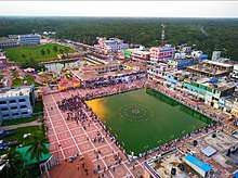
- Fashion Square, Char Fasson
- Char Kukri Mukri
- Taruya Sea beach
- Charfasson Eid Gah
- Charfasson BM. Town-Hall
- Maya Bridge
- Fashion Square
- Charfasson Binodon Park
- Betuya launch ghat
- Ministry khamar Bari
- Char Kajur Gachiya
- Dakshin Aicha Thana
- Charfasson Bus Terminal
See also
- Upazilas of Bangladesh
- Districts of Bangladesh
- Divisions of Bangladesh
References
- "Char Fasson Upazila - Banglapedia". en.banglapedia.org. Retrieved 2020-06-09.
- Md Harun Rashid Helali (2012). "Char Fasson Upazila". In Sirajul Islam and Ahmed A. Jamal (ed.). Banglapedia: National Encyclopedia of Bangladesh (Second ed.). Asiatic Society of Bangladesh.
- "বাংলাদেশ পরিসংখ্যান ব্যুরো-গণপ্রজাতন্ত্রী বাংলাদেশ সরকার". www.bbs.gov.bd. Retrieved 2020-06-09.
- "Economic Census Report-2013". Economic Census Report. January 13, 2016. Retrieved June 10, 2020.
- "Population Census Wing, BBS". Archived from the original on 2005-03-27. Retrieved November 10, 2006.
- "Economic Census Report-2013". Economic Census Report. January 13, 2016. Retrieved June 10, 2020.
- "District Statistics 2011: Bhola" (PDF). Bangladesh Bureau of Statistics. Archived from the original (PDF) on 2014-11-13. Retrieved July 25, 2014.
- "List of Institutions". Ministry of Education. Retrieved July 15, 2014.
- "Economic Census Report-2013". Economic Census Report. January 13, 2016. Retrieved June 10, 2020.
- "Economic Census Report-2013". Economic Census Report. January 13, 2016. Retrieved June 10, 2020.
| Upazila/Thana: |
| |
|---|---|---|
Capital: Barisal | ||
| Barguna District | 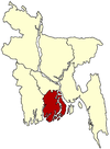 | |
| Barisal District | ||
| Bhola District |
| |
| Jhalokati District | ||
| Patuakhali District | ||
| Pirojpur District | ||
| Upazila/Thana: | ||
|---|---|---|