Madhupur, Bangladesh
Madhupur (Bengali: মধুপুর) is a town of Madhupur Upazila, Tangail, Bangladesh. The town is 51 kilometres (32 mi) northeast of Tangail city, 47 kilometres (29 mi) southwest of Mymensingh, and 137 kilometres (85 mi) northwest of Dhaka, the capital.
Madhupur মধুপুর | |
|---|---|
Town | |
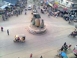 Madhupur Bus Stand, Tri-junction of three important roads of Bangladesh, The three roads goes to Tangail, Mymensingh and Jamalpur respectively. The pineapples signify the pineapple-growing area around Madhupur. | |
 Madhupur | |
| Coordinates: 24°37′N 90°1.5′E | |
| Country | Bangladesh |
| Division | Dhaka Division |
| District | Tangail District |
| Upazila | Madhupur Upazila |
| Incorporated | 1995 |
| Government | |
| • Type | Pourashava |
| • Mayor | Md. Masud Parvej (Bangladesh Awami League) |
| Area | |
| • Total | 24.77 km2 (9.56 sq mi) |
| Population | |
| • Total | 56,342 |
| • Density | 2,300/km2 (5,900/sq mi) |
| Time zone | UTC+6 (BST) |
| Postal codes | 1996 |
| Area code(s) | 9228 |
| Website | madhupur |
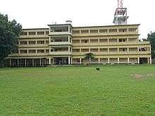
Madhupur Shahid Smrity Higher Secondary School is located in the middle of the town
Demographics
According to the 2011 Bangladesh census, Madhupur town had 13,713 households and a population of 56,342. The literacy rate (age 7 and over) was 56.7% (male: 58.7%, female: 54.5%).[1]
See also
References
- "Community Report: Tangail" (PDF). Population & Housing Census 2011. Bangladesh Bureau of Statistics. Archived from the original (PDF) on 2016-12-02. Retrieved 2017-06-18.
This article is issued from Wikipedia. The text is licensed under Creative Commons - Attribution - Sharealike. Additional terms may apply for the media files.