Lakshmipur District
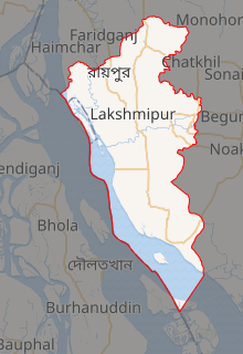
Lakshmipur or Laxmipur District (Bengali: লক্ষ্মীপুর জেলা, Lakshmipur Jela also Lakshmipur Zila) with an area of 1455.96 km², is a district of Bangladesh. It is bordered by Chandpur District to the north, Bhola and Noakhali districts to the south, Noakhali District to the east, and Barisal and Bhola districts to the west.
Lakshmipur লক্ষ্মীপুর | |
|---|---|
Expandable map of Lakshmipur District | |
| Coordinates: 22.9500°N 90.8250°E | |
| Country | |
| Division | Chittagong Division |
| Government | |
| • District Commissioner | Anjon chandra paul |
| Area | |
| • Total | 1,440.39 km2 (556.14 sq mi) |
| Population (2011 census) | |
| • Total | 1,729,188 |
| • Density | 1,200/km2 (3,100/sq mi) |
| Literacy rate | |
| • Total | 62.26%[1] |
| Time zone | UTC+06:00 (BST) |
| Postal code | 3700 |
| HDI (2018) | 0.596[2] medium · 11th of 21 |
| Website | www |
Subdivisions
The upazilas under this district are:[3]
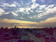
A Road to Dhaka from Lakshmipur at dawn
The district of Lakshmipur consists of 4 municipalities, 58 union parishads, 514 villages, 3539 mosques, 45 temples, and 1 church.[1]
- Lakshmipur Adarsha Samad Government High School
- Panpara high School,Ramgonj
- Sreerampur High School,Ramgonj
Notable residents
- Tufail Mohammad, second recipient of the Nishan-e-Haider
- Mohammad Mohammadullah, 3rd President of Bangladesh (24 December 1973 – 25 January 1975)
- Abdul Matin Chowdhury,(1 May 1921 – 24 June 1981), He served as the 14th Vice-chancellor of the University of Dhaka.
- Mohammad Toaha, language activist of the Bengali Language Movement and politician
- A. S. M. Abdur Rab, Bangladeshi politician
- Mohammad Noman, political leader of Jatiyo Party
- Selina Parvin, (1931–1971), journalist and poet, martyr of Bangladesh War of Independence, was born in Ramganj Upazila
- A.K.M. Shahjahan Kamal, Minister of Civil Aviation and Tourism (3 January 2018- )
- Riman Zahir Chowdhury -- Pilot
- Muhammad Abdullah, academic.
- Dr. A. S. M. Maksud Kamal, Pro-VC(Education), University of Dhaka
References
| Wikimedia Commons has media related to Lakshmipur District. |
| Wikivoyage has a travel guide for Lakshmipur District. |
- লক্ষ্মীপুর জেলা তথ্য বাতায়নে আপনাকে স্বাগতম (in Bengali). Office of the Deputy Commissioner, Lakshmipur. Archived from the original on 23 August 2011. Retrieved 14 February 2012.
- "Sub-national HDI - Area Database - Global Data Lab". hdi.globaldatalab.org. Retrieved 2020-03-18.
- Md. Shajahan (2012). "Lakshmipur District". In Sirajul Islam and Ahmed A. Jamal (ed.). Banglapedia: National Encyclopedia of Bangladesh (Second ed.). Asiatic Society of Bangladesh.

This article is issued from Wikipedia. The text is licensed under Creative Commons - Attribution - Sharealike. Additional terms may apply for the media files.